The Global Positioning System (GPS) is a great navigation aid – unless you lose the signal while negotiating a complicated spaghetti junction. That's bad enough for conventional cars, but for autonomous vehicles it could be catastrophic, so the University of California, Riverside's Autonomous Systems Perception, Intelligence, and Navigation (ASPIN) Laboratory under Zak Kassas is developing an alternative navigation system that uses secondary radio signals, such as from cell phone systems and Wi-Fi to either complement existing GPS-based systems or as a standalone alternative that is claimed to be highly reliable, consistent, and tamper-proof.
Today, there are two global satellite navigation systems in operation, the US GPS and the Russian GLONASS, with the European Galileo system set to become fully operational in the next few years, and plans for the Chinese Beidou system to extend globally by 2020. These have revolutionized navigation, surveying, and a dozen other fields, but GPS and related systems still leave much to be desired. By their nature, GPS signals are weak and positions need to be confirmed by several satellites, so built up areas or mountainous areas can make the system useless. In addition, GPS signals can be deliberately or accidentally jammed or spoofed due to insufficient encryption and other protections.
In military circles, various supplementary systems are employed with everything from submarines to foot soldiers also using Inertial Navigation System (INS) that emply accelerometers and compasses to calculate positions from the last good GPS fix, but these only work for a limited time before they start to drift.
Despite the promise of future centimetric GPS systems, even a combination of GPS and INS is still inadequate for autonomous vehicles like self-driving cars and drones. Designers have fallen back on using radar, lidar, cameras, and other sensors to make up for these deficiencies, which Kassas calls an "everything but the kitchen sink" approach and is overly complicated to say the least.
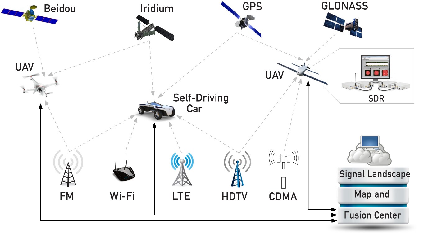
As an alternative, the UCR team is developing a system based on Signals Of Opportunity (SOP), which are radio transmissions from Wi-Fi, mobile phone towers, terrestrial radio and television stations, and non-navigational satellite signals, It's a bit like how some smartphone GPS apps fine tune GPS locations using Wi-Fi and mobile signals. The idea is to use the variety of radio signals that permeate the environment so the system can make GPS fixes more precise and accurate or take over entirely when GPS signals fail.
To achieve this, the team made a theoretical analysis of the SOPs available, built specialized software-defined radios (SDRs) that can use timing and positioning information from SOPs, and created navigation algorithms before trying the system out on drones and ground vehicles. The hope is this approach will one day make autonomous vehicles safe and practical.
"Autonomous vehicles will inevitably result in a socio-cultural revolution," says Kassas. "My team is addressing the challenges associated with realizing practical, cost-effective, and trustworthy autonomous vehicles. Our overarching goal is to get these vehicles to operate with no human-in-the loop for prolonged periods of time, performing missions such as search, rescue, surveillance, mapping, farming, firefighting, package delivery, and transportation."
The research was presented at the 2016 Institute of Navigation Global Navigation Satellite System Conference.
The video below outlines the SOP system.
Source: UCR