Space

First satellite to track global winds fired into orbit

First satellite to track global winds fired into orbit
The Aeolus satellite will used advanced lasers to track global winds
The Aeolus satellite will used advanced lasers to track global winds 
View 15 Images
Artist's impression of the Aeolus being released from the faring
1/15
Artist's impression of the Aeolus being released from the faring
The Aeolus satellite will beam lasers into the atmosphere and monitor the backscattered light to track global weather patterns
2/15
The Aeolus satellite will beam lasers into the atmosphere and monitor the backscattered light to track global weather patterns
ESA’s Aeolus wind satellite was launched into orbit atop a Vega rocket
3/15
ESA’s Aeolus wind satellite was launched into orbit atop a Vega rocket
The Aeolus satellite was lifted into space by a Vega rocket
4/15
The Aeolus satellite was lifted into space by a Vega rocket
The ESA's Aeolus mission lifts off from French Guiana
5/15
The ESA's Aeolus mission lifts off from French Guiana 
The Aeolus satellite is launched into space on August 23
6/15
The Aeolus satellite is launched into space on August 23
The ESA's Aeolus satellite is named after the figure in greek mythology who was appointed "keeper of the winds"
7/15
The ESA's Aeolus satellite is named after the figure in greek mythology who was appointed "keeper of the winds"
The Aeolus satellite will used advanced lasers to track global winds
8/15
The Aeolus satellite will used advanced lasers to track global winds 
Artist's impression of the Aeolus satellite in orbit
9/15
Artist's impression of the Aeolus satellite in orbit
The Aeolus satellite will used advanced lasers to track global winds
10/15
The Aeolus satellite will used advanced lasers to track global winds 
Better understanding of the way the wind blows can greatly boost the accuracy of weather predictions
11/15
Better understanding of the way the wind blows can greatly boost the accuracy of weather predictions
Aeolus will soon start using advanced instruments to beam lasers into the atmosphere and paint a more detailed picture of global wind patterns than ever before
12/15
Aeolus will soon start using advanced instruments to beam lasers into the atmosphere and paint a more detailed picture of global wind patterns than ever before
Rendering of the Aeolus satellite in orbit
13/15
Rendering of the Aeolus satellite in orbit
The Aeolus satellite is designed to help us better map and predict winds, such as the category five Hurricane Lane seen here from the International Space Station
14/15
The Aeolus satellite is designed to help us better map and predict winds, such as the category five Hurricane Lane seen here from the International Space Station
The Aeolus satellite in the launch tower ahead of launch
15/15
The Aeolus satellite in the launch tower ahead of launch
View gallery - 15 images

Better understanding of the way the wind blows can greatly boost the accuracy of weather predictions, which would mean big things for agriculture, transport and, of course, our preparedness for severe storms. A new satellite built by the European Space Agency has now slipped into orbit, and will soon start using a sophisticated instrument to bounce lasers through the atmosphere to paint a more detailed picture of global wind patterns than ever before.

Named after the figure in Greek mythology that the gods appointed "keeper of the winds," ESA's Aeolus satellite is designed to plug gaps in the Global Observing System, an international effort to monitor the state of the atmosphere and ocean surface for the purposes of weather modeling.

At present, our monitoring of global wind patterns are a mishmash of observations taken from weather balloons, land stations, aircraft and ship measurements, along with indirect satellite measurements. With the direct observations provided by the balloons mostly coming from the Northern Hemisphere and the observations coming from the Southern Hemisphere largely indirect, a few sizeable holes remain.

Better understanding of the way the wind blows can greatly boost the accuracy of weather predictions

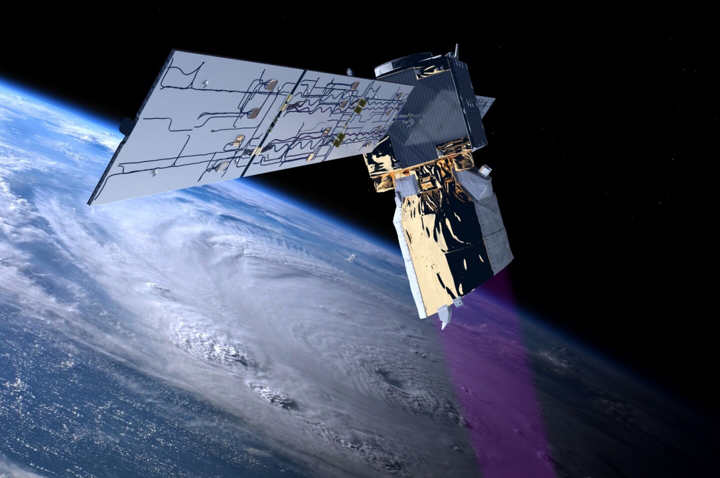
The Aeolus satellite is the first mission to profile Earth's winds on a global scale, and it will do so using a single laser-based scientific instrument called Aladin, or the Atmospheric Laser Doppler Instrument.

As a type of Doppler wind lidar, Aladin shoots short pulses of light in the ultraviolet spectrum through the atmosphere and then uses an onboard telescope and receiver to collect and measure the light that makes its way back. This light becomes scattered by particles of gas and dust and water droplets in the atmosphere, and because these scattering particles move with the wind, they shift the wavelength of the returning light ever so slightly.

The Aeolus satellite will beam lasers into the atmosphere and monitor the backscattered light to track global weather patterns

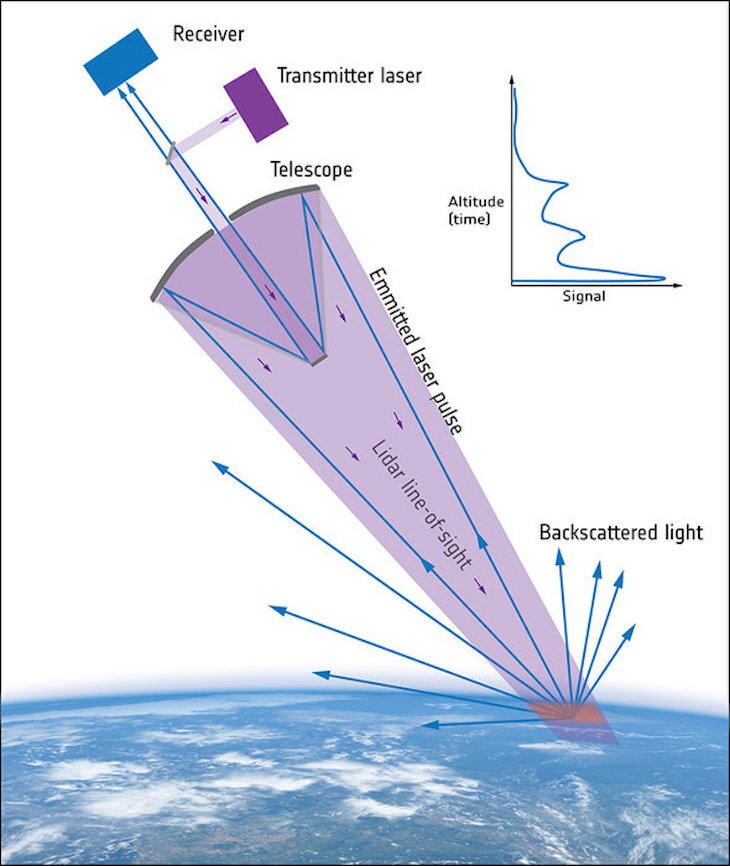
By measuring these changes, Aladin is able to determine the velocity of the winds below and relay that information in near real-time to scientists on the ground. As the satellite scans the atmosphere it will provide up to 100 wind profiles every hour, allowing meteorologists to make predictions about the weather with much higher precision.

"Aeolus epitomises the essence of an Earth Explorer," says Jan Wörner, ESA Director General. "It will fill a gap in our knowledge of how the planet functions and demonstrate how cutting-edge technology can be used in space."

After lifting off from French Guiana on Wednesday night atop a Vega rocket, the 1,360-kg (3,000-lb) Aeolus satellite entered polar orbit and established contact with ground control within three hours. With its solar array deployed and facing the Sun, Aeolus is said to be operating nominally, with its mission slated to last three years. The coming few months will see controllers checking and calibrating the satellite.

Source: European Space Agency

View gallery - 15 images
1 comment
1 comment
piperTom
The mission is to last three years. What happens then? Is there some consumable that runs out? Orbit decays? Budget problems?