Hundreds of kilometers from any major city, the remote south-east corner of Australia is home to spectacular coastline, thick native flora and as we came to learn, some rather hilly and rough terrain. Over the holiday season, writer Nick Lavars ventured into the forest on two-wheeled adventure to see it all from the seat of his bike. This is a story of the (many) ups and downs.
"Why am I doing this again?" I asked a friend, half-joking but also half-serious, as he helped me strap enough luggage to fill a small suitcase onto the seatpost of my bike. I was about to leave the perfectly agreeable holiday house we'd rented in the Australian coastal town of Mallacoota to ride alone into the forest for two days. "Yeah, look I don't know," he responded with a smile, but with just enough sincerity to suggest he didn't think it was the brightest of my ideas.
You might imagine that a person cycling alone into the forest is pondering the answers to some big questions, and in this case you'd be absolutely correct. Will the chocolate in my bag melt before I get to camp? How accurate is that elevation graph Google Maps offers when you enter a route? Will I see snakes? And is 5 liters of water enough? (spoiler: it wasn't).
Ahead of me as I turned out of the driveway and into the forest that pleasant but threateningly warm summer morning was a stretch of sealed road, followed by a section of gravel and then unknown roads of unknown quality. Well, not entirely unknown. That Google Maps labels them as "tracks" and "trails" suggested I wasn't in for the smoothest of rides. The destination was the junction of Imlay Creek and the Wallagaraugh River around 43 mi (70 km) away, which funnily enough join together to descend from the hills, and flow right past our perfectly agreeable holiday house into the ocean.

There were plenty of very good reasons not to undertake this particular biking adventure. I knew this because of the trouble I had convincing anybody to come with me. Why do that when you can enjoy that very same waterway from the huge deck in our backyard with a cold drink in your hand? Isn't it going to be kind of dangerous? How is riding a loaded bike through the forest for two days anyone's idea of fun?
All valid points. The fact was, however, I saw enough half-baked reasons to do this cycling trip that together provided me with the impetus to turn out of the driveway that morning. Though they didn't provide me with one clear, singular answer as to why, they were enough for me to say, why not?
It could be an epic adventure? I'll get to take in tons of forest scenery? I'll get to give my new-ish Specialized gravel bike the working over it has been asking for. It's a good opportunity to road-test Apidura's Expedition Saddle Pack (full review coming soon). Plus camping is fun and, as is established scientific fact, swimming in natural waterways is much more enjoyable when you've had to earn it.
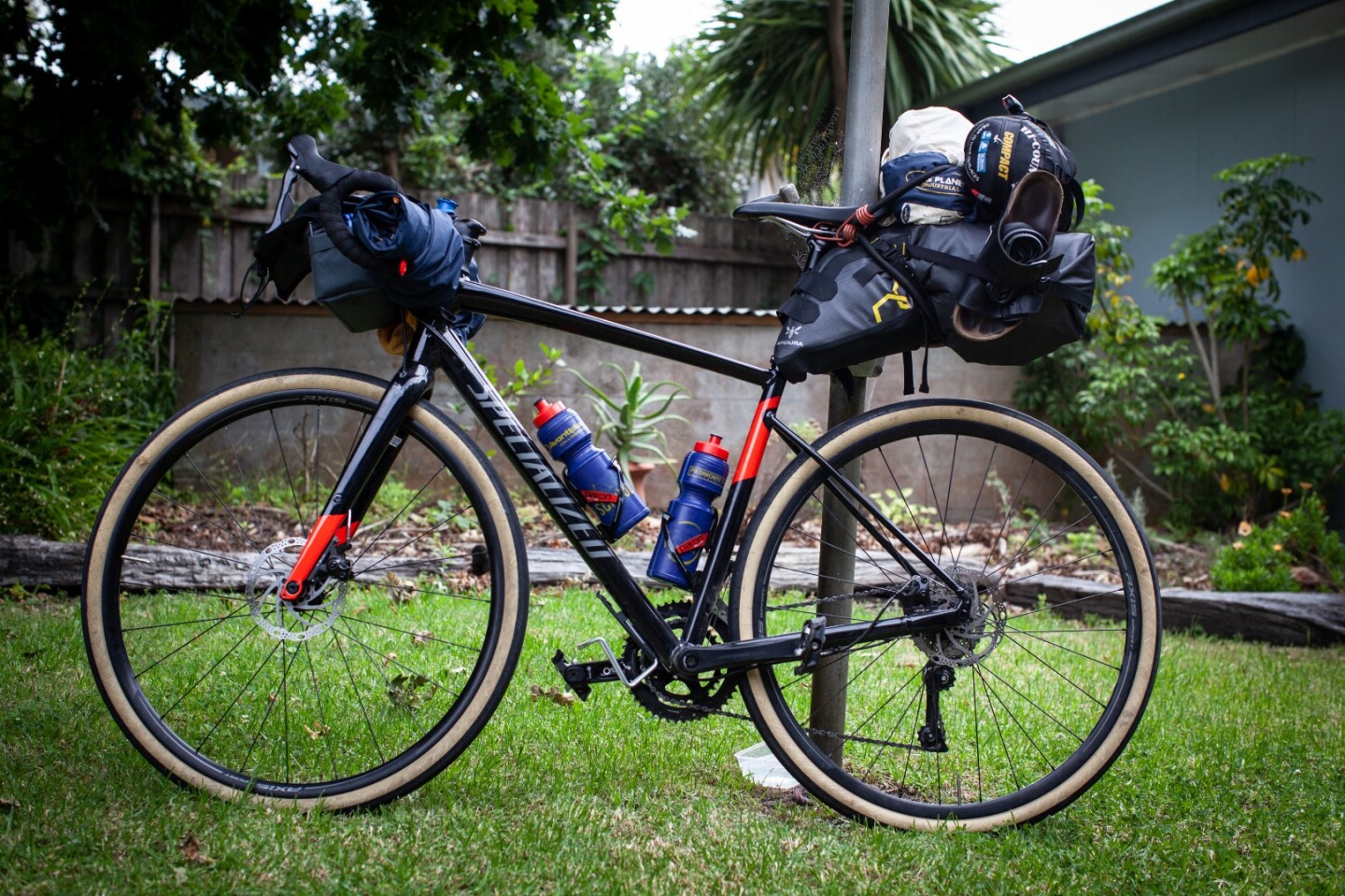
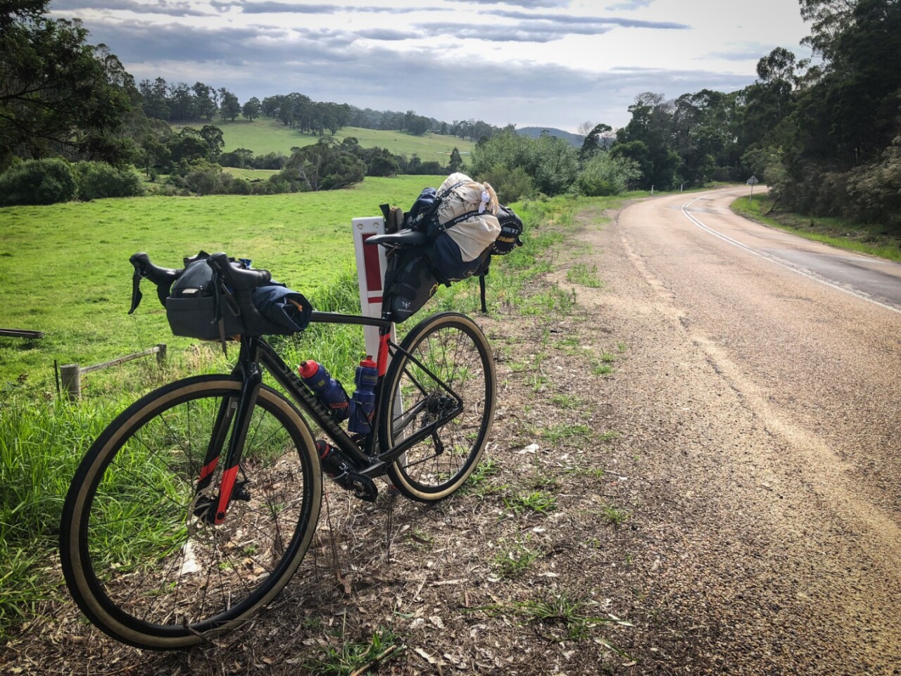
By virtue of being spacious and sturdy, the poor saddle pack ended up bearing most of my supplies for the two-day trip. This included a bladder with three liters of water in addition to my stacked bottle cages, a tent fly and pegs, spare underwear and socks, a gas canister, lightweight stove and cook set, food, sleeping bag, sandals, an inflatable sleeping mat and spare bike tubes. Strapped to the handlebars were a tent pole and tent inner, while some essentials like sunscreen and snacks were stuffed into my handlebar bag.
I can't imagine too many experienced bikepackers endorsing this kind of setup, but this is what I had to work with, and make it work I was determined to do.
I imagine that under regular conditions the first leg of my journey would be a very enjoyable cycling experience. With only the odd car here and there, the lovely, mildly hilly section of smooth bitumen weaves its way through Croajingalong National Park and its thickets of Australian gumtrees until it rejoins the coastal highway around 12 miles inland. Though the scenery certainly added to the experience, it was pretty regularly interrupted by the need to make strapping and attitude adjustments to keep my little show on the road.
I had loaded up the saddle bag with so much weight that just a few kilometers down the road it was sagging low enough to drag on top of the rear tire as it turned – not really conducive to the idea of forward motion. I should point out that the bag is simply not designed to carry all this stuff and I was certainly pushing it to its limits. At least our road-testing would be rigorous.
Luckily, the last-minute strap my friend sympathetically wrapped around this mish-mash of items dangling behind me was enough to secure it into one solid, reassuring lump, all it needed was some diligent fastening. After a few roadside attempts and some serious doubts about the viability of this whole endeavor, I was able to get it right, hop back in the saddle and start to enjoy the ride.
Once I'd made my way up to the highway I had a couple of miles to cover in its emergency stopping lane until I could veer off the bitumen and forget about cars altogether. This turnoff spat me out onto a long, winding gravel road leading through state forest up to a place called Wangarabell.

Although it presented a slight detour, I was intent on visiting Wangarabell for a few reasons. The internet says it has a population of nine and I wanted to know what that looked like. Are we talking a few farms, a row of houses maybe? How seriously are these people taking their census obligations? It also happened to be on the edge of the Genoa River, which meant cooling off by way of a lunchtime swim was a very real possibility.
Grinding it out on this gravel road was gloriously isolating. Save for two cars that rumbled past soon after I got off the highway, I had this forest all to myself and that was to be the theme for the rest of the day. There was a solid chunk of slow and steady climbing to be done up to around the 20-mile mark of my overall journey, and then it was a thrilling, winding descent down to my delightfully underwhelming destination.
The forest was so thick around Wangarabell that I never even saw the Genoa River. My visions of a lunch relaxing on the riverbank, feasting on leftover rice 'n' bean burritos before taking a refreshing dip were quickly quashed by trees. Lots of them. Which was fine. Onto the next.

After fending off an army of ants and packing my food back into its precarious pantry over my back tire, it was back on the bike for a slight downhill where the abundant forest gave way to rolling hills and paddocks. And this seemed to be the heart of Wangarabell. It was about what you'd expect, truth be told. I saw a few nondescript farmhouses and some cows, before a short-lived stretch of bitumen carried me over a creek and back into the forest.
And that was where the real fun began, because "Sarah Allen Road" soon became "Sarah Allen Track," a mercilessly undulating fire road that was surely only ever traveled by park rangers in beefy 4WDs. The novelty of being far off the beaten path with absolutely no one around was fun to begin with, and gave me the energy to tackle the rough spirit-breaking hills. Well, the first few of them at least.
An initial long and steady climb was followed by an absolutely brutal one, which featured a state border crossing between Victoria and New South Wales somewhere along the way. It's not that I didn't see the border sign, it's simply that pulling over for a photo seemed surplus to requirements at a time when I needed all the energy I could gather to remain upright.

I may have been in an entirely different state, but the early signs were that New South Wales did hills just as well Victoria. The unforgiving undulations continued for another 10 miles, by which point I had given up trying to pedal my bike and was simply pushing it upwards, like a tired laborer pushing a wheelbarrow of bricks up a hill at the end of a day's work.
I had no phone reception but, in one of my wiser preparatory moves, had saved the area offline on Google Maps. This meant I could at least see where I was in relation to camp and also draw on an elevation graph to gauge the severity of the hills ahead of me. I made a point of checking this very frequently, and the spirits were certainly lifted when I reached what appeared to be the end of the uphills, leaving nothing but a relaxing descent over five miles or so to camp.
Flying down these forest roads on a fully loaded bike was about as much fun as it sounds, and the rough terrain was a lot more forgiving on the way down than it was on the way up. The hills were mine to enjoy, and enjoy them I did, right up until I realized the one and only shirt I had with me was not on my body. Nor was it in my handlebar bag, where a clear-thinking person would have safely stowed it away.
It appeared that in my hot, exhausted delirium, I'd ripped it off and used it to wipe sweat and sunscreen from my eyes before draping it over my handlebars. I remembered doing this vaguely, but had no idea how much time had passed since. To make matters worse, the sunscreen lodged into the external pocket of my handlebar bag had decided to jump ship somewhere along the way as well.
So here I was in the middle of the forest, in the middle of the Australian summer, hours from anywhere, with no shirt and no sunscreen. Now I'm no Bear Grylls, but this struck me as a bad approach to survival. I had no choice, I simply had to drop the bike and hike back up the hill until I found my lost property.
Backtracking isn't fun at the best of times, and especially not when you're alone, trudging uphill in search of something that could be five minutes or five hours away. While I wouldn't go so far as to say I was blessed by the forest gods that day, they didn't punish me too harshly, kindly placing both my shirt and sunscreen in the middle of the road about 40 minutes walking back up the hill.
Once I'd gotten dressed again I climbed back on the bike and finished the short ride into camp, an area known as Newton's Crossing for reasons I'm unaware of. The refuge consisted of sites with small fireplaces dotted throughout the trees, all packed into a tight V-shaped slice of land flanked by two picturesque waterways.

Whoever Newton was he sure knew how to pick a river crossing. Both the creek and river cascade over and in between picturesque rock formations that make them easy to explore on foot and conveniently funnel the waterways into small pools for overheated cyclists to cool off in. I took full advantage of this by dipping my weary noggin into three different but equally chilling pools, inadvertently causing radical fluctuations in my body temperature. They say that's good for you, right?
I was so tired by the time that it came to set up my tent that I did so blithely in nothing but my wet underwear, probably an amusing sight for the couple camping nearby. I also went to the trouble of making a small fire, thinking the smoke would help repel the mosquitoes. I wasn't awake long enough for it to really matter.
After treating myself to some rehydrated Thai cuisine and some intact chocolate I hit the sack with a full-enough belly and no troubles on the mind except for one small dilemma. I had packed 170 oz of water with me for two days and drunk more than 135 oz of it on day one (four of five liters!). Have you ever been so hot and thirsty that you find mouthfuls of H2O simply irresistible, even when they've been slowly warmed by the blistering sun to temperatures resembling a warm cup of soup?
I battled this temptation all afternoon and thought I resisted admirably under the circumstances, but the fact was I was running out of water and regretting not bringing along the LifeStraw a friend kindly offered me at the last minute. One option would be to boil water from the river, and though that might make it drinkable the fact was this gritty river water was high on murk and therefore low on appeal. A better option, I figured, was to make a route adjustment.
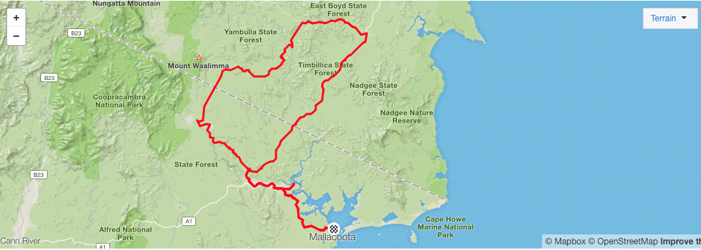
My original plan was to return to Mallacoota via a similar, but different route through the forest. But I'd seen enough to know that another day battling it out on those fire roads with little water was a bad idea, so the new plan was to cut across and return via the highway, where surely I could resupply.
The first part of my revised plan went off without a hitch. In fact it was spectacular. I had a short stint on hilly gravel out of camp before I turned onto my first bitumen for 24 hours. Again, this was a wonderfully scenic stretch of deserted forest road with enough winding undulations to get the heart pumping on the way up and the adrenaline going on the way down. After suffering a savage defeat at the hands of the fire roads the day before, this was the perfect way to lift the spirits.

By the time the road rejoined the main coastal highway around 8 miles later I was back in mobile phone range, meaning I could consult the internet for some shops of some kind. As it turned out, this remote corner of Australia, is pretty, well, remote. Unless I wanted to ride in the wrong direction, my best bet for resupplies was Gypsy Point Lodge, a riverside restaurant 31 mi away (50 km), just shy of Mallacoota. By this point I was down to my last bottle of water, but comforted by my assumption that you can't suffer too much from dehydration if you've got five liters of water in you. Surely?
With that, it was time to get settled into the emergency stopping lane for a long grind back down the highway. As the only major road connecting towns along this stretch of Australia's coast, there was no shortage of cars flying past in both directions but none came too close for comfort. In fact, there was even the odd toot and fist pump out of the window for moral support.
There seems to be something intriguing about a person traveling down the highway on a fully loaded bike when a regular ol' car will do. After being lured into a roadside rest stop by the possibility of drinking water, finding no drinking water so lying down on a picnic table with my eyes closed for a while instead, an older man with a grey ponytail and a long handlebar moustache came over for a chat.

His inquiries seemed motivated by the very same question I'd asked myself at the beginning, along the lines of "why the hell are you doing this?" though he articulated it in a perfectly friendly manner, wondering where I'd come from and where I was going. He was a truck driver, he said, and was crippled by fear every time he passed a cyclist on the road in his huge semi-trailer. "If I hit one ... I .. I don't think I could ever drive again," he said, trailing off and diverting his gaze to the ground. He then wished me luck and made for his RV.
Tucking myself into the emergency lane a little tighter than before, I then carried on down the highway dreaming of a cold drink and some kind of hot food. This time I took the opportunity to snap a triumphant photo at the border crossing, forever etching into the folklore of my iPhoto library the time I rode my bike to New South Wales, should anyone ever doubt me.
I was very eager to turn off the highway and onto the scenic road back down to Mallacoota, because it would mean less traffic, hopefully some downhill, but most importantly, that Gypsy Point was close. The restaurant turned out to be a bit of a detour and pretty close to my final destination. Feeling hot and tired but overall pretty good, I did toy with the idea of just continuing on to finish the job, but figured I'd earned myself a break.
"So, just out for a little ride are ya mate?" asked the bemused waiter at the restaurant, eyeing my loaded bike out the window as I inhaled half an iced Coke, paused to order second one, and finished off the glass. He only grew more baffled as I described the route I'd taken through the forest, revealing that, yes, he was familiar with the roads and that, no, he'd never entertained the idea of traveling them on a bike.
After lounging around inside the air-conditioned restaurant over a chicken burger, liters of cold water and a coffee, I returned to the bike for what I envisioned to be a victory lap of sorts. I'd already ridden more than 80 miles on a heavy bike and had only a few more to cover before home, so I imagined it would feel a little like the lap marathon runners cover inside the stadium at the Olympics. Just a fun little celebratory stretch in front roaring fans acknowledging all the hard work that had been done.

These positive vibes continued for around half an hour, by which point I figured I must be approaching town. My calculations turned out to be some ways off and the celebrations were cut short when I came across a sign bearing the news that Mallacoota was still 6 miles away, another half an hour of riding. At least I had my shirt and sunscreen.
It was mid-afternoon by the time I returned to the house, with the rest of the day spent sprawled out on the lawn under a tree with lots of water and a little reflection. The adventure was, well an adventure, and the cycling itself had all the right elements with scenic sealed roads and deserted gravel, all surrounded by lush, native Australian flora without a single snake encounter. My friends gathered around to, first of all, make sure I was alive, and second, to see how it all went. The highs and lows of the journey became clearer as I relived it, though I realized I still had no clear answer as to why you'd do something like that in the first place. But would I go again? Sure, why not.