Environment

Rectangular icebergs and the snowy spectacle of NASA’s latest Antarctic aerial mission

Rectangular icebergs and the snowy spectacle of NASA’s latest Antarctic aerial mission
This bizarrely, but not unusual, rectangular iceberg is called a tabular iceberg and was discovered by IceBridge just a few days ago floating off the Larsen C ice shelf
This bizarrely, but not unusual, rectangular iceberg is called a tabular iceberg and was discovered by IceBridge just a few days ago floating off the Larsen C ice shelf
View 27 Images
This bizarrely, but not unusual, rectangular iceberg is called a tabular iceberg and was discovered by IceBridge just a few days ago floating off the Larsen C ice shelf
1/27
This bizarrely, but not unusual, rectangular iceberg is called a tabular iceberg and was discovered by IceBridge just a few days ago floating off the Larsen C ice shelf
Flying through the Neptune Range of the Pensacola Mountains
2/27
Flying through the Neptune Range of the Pensacola Mountains
From a flight on October 11
3/27
From a flight on October 11
A crack developing in the Filchner Ice Shelf meets a coastal polynya
4/27
A crack developing in the Filchner Ice Shelf meets a coastal polynya
A large rift bisecting part of the Stancomb-Willis Glacier Tongue, East Antarctica
5/27
A large rift bisecting part of the Stancomb-Willis Glacier Tongue, East Antarctica
Incredibly crevassed ice
6/27
Incredibly crevassed ice
Edge of the Stancomb Ice Shelf, East Antarctica
7/27
Edge of the Stancomb Ice Shelf, East Antarctica
A crevasse field at sunset on the Stancomb-Wills Glacier, East Antarctica
8/27
A crevasse field at sunset on the Stancomb-Wills Glacier, East Antarctica
Grease sea ice tendrils forming at the edge of the Filchner ice shelf
9/27
Grease sea ice tendrils forming at the edge of the Filchner ice shelf
Mountains in the Shackleton Range, bordering Recovery Glacier, East Antarctica
10/27
Mountains in the Shackleton Range, bordering Recovery Glacier, East Antarctica
An iceberg surrounded by water and sea ice floes in the Weddell Sea. The submerged portion of the iceberg is partially visible (bright blue)
11/27
An iceberg surrounded by water and sea ice floes in the Weddell Sea. The submerged portion of the iceberg is partially visible (bright blue)
Snow blowing off the Filchner Ice Shelf
12/27
Snow blowing off the Filchner Ice Shelf
Blue ice near Slessor Glacier in Antarctica
13/27
Blue ice near Slessor Glacier in Antarctica
Coastal polynya near the Filchner Ice Shelf, Antarctica
14/27
Coastal polynya near the Filchner Ice Shelf, Antarctica
An iceberg in the Weddell Sea surrounded by sea ice
15/27
An iceberg in the Weddell Sea surrounded by sea ice
Mt. Balfour in the Antarctic Peninsula
16/27
Mt. Balfour in the Antarctic Peninsula
Cape Jeremy, flanking the northern entrance to George VI Sound, Antarctic Peninsula
17/27
 Cape Jeremy, flanking the northern entrance to George VI Sound, Antarctic Peninsula
A cirque on the flank of the Dyer Plateau east of George VI Ice Shelf, Antarctic Peninsula
18/27
A cirque on the flank of the Dyer Plateau east of George VI Ice Shelf, Antarctic Peninsula
Heavily crevassed land ice in the northern Antarctic Peninsula
19/27
Heavily crevassed land ice in the northern Antarctic Peninsula
A heart-shaped calving front of a glacier in northwest Greenland, as seen during an Operation IceBridge flight on Mar. 27, 2017
20/27
A heart-shaped calving front of a glacier in northwest Greenland, as seen during an Operation IceBridge flight on Mar. 27, 2017
An iceberg floating in Antarctica's McMurdo Sound
21/27
An iceberg floating in Antarctica's McMurdo Sound
The massive rift in the Antarctic Peninsula's Larsen C ice shelf, photographed on Nov 10, 2016
22/27
The massive rift in the Antarctic Peninsula's Larsen C ice shelf, photographed on Nov 10, 2016
West Antarctica. Nov 5, 2016
23/27
West Antarctica. Nov 5, 2016
A multi-layered lenticular cloud hovering near Mount Discovery, a volcano about 70 km (44 mi) southwest of McMurdo Station on Antarctica’s Ross Island, Nov 24, 2013
24/27
A multi-layered lenticular cloud hovering near Mount Discovery, a volcano about 70 km (44 mi) southwest of McMurdo Station on Antarctica’s Ross Island, Nov 24, 2013
Antarctica's tallest peak, Mount Vinson, on Oct. 22, 2012
25/27
Antarctica's tallest peak, Mount Vinson, on Oct. 22, 2012
Arctic flight in April 2018, Helheim Glacier (left) recently calved a large iceberg (right) that has not capsized or overturned yet
26/27
Arctic flight in April 2018, Helheim Glacier (left) recently calved a large iceberg (right) that has not capsized or overturned yet
Icefall on the flank of Clifford Glacier, Antarctica, November, 2017
27/27
 Icefall on the flank of Clifford Glacier, Antarctica, November, 2017
View gallery - 27 images

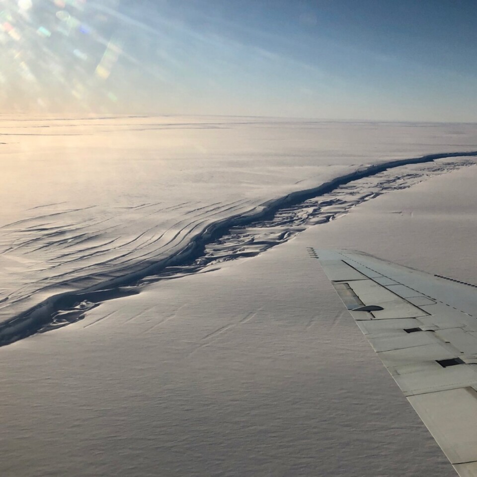
NASA's long-running aerial survey monitoring changes in polar ice is currently flying over Antarctica, gathering measurements of land and sea ice. The data it gathers will be compared to measurements from the newly orbiting ICESat-2, a satellite with the most advanced laser altimeter NASA has ever launched, while the images captured provide a breathtaking look in and around the frozen continent.

Operation IceBridge kicked off in 2009, ostensibly as a project to maintain continuity in polar ice measurements after the first ICESat mission ended in 2009. The IceBridge mission is currently funded until 2020 but at this stage there is no indication that NASA will extend the operation now that ICESat-2 is up and running.

The latest IceBridge mission began on October 10, and is spending the following five weeks flying on paths underneath ICESat-2 in order to compare measurements and confirm the accuracy of the new satellite's data.

A large rift bisecting part of the Stancomb-Willis Glacier Tongue, East Antarctica

"This campaign is our second-to-last Antarctic campaign and it is arguably the most scientifically diverse that IceBridge has ever done," says IceBridge's project scientist, Joe MacGregor. "We're going to be revisiting classic IceBridge targets: flights along glacier flowlines that have been surveyed since 2002, long-term sea ice flights, and new targets across West Antarctica. More than two dozen of these mission designs are relevant to both IceBridge and ICESat-2."

While the measurements gathered by ICESat-2 will offer scientists a valuable continued insight into important polar ice changes, the IceBridge mission offered the added value of extra radar systems and imaging processes. As well as that, we have been treated to a vast array of spectacular photographs taken by the researchers as they journeyed over remote stretches of our polar regions.

Take a look through our gallery to see some of the latest snaps from the IceBridge Antarctica operation, as well as some highlights of other amazing sights captured on earlier missions.

Source: NASA ICE Twitter

View gallery - 27 images
3 comments
3 comments
ljaques
The 91 new volcanoes discovered under the Antarctica ice sheets couldn't =possibly= have any effect on glaciers, could it? (This brings the total to 138.)
This is all anthropomorphic globular swarming, kumbaya, right?
Thank you, NASA, for your continued objectivity and lack of any political motivation. <snort>
nono
What always strikes me is that it does not matter if a massive catastrophe is coming because of our actions or if it is entirely natural. There are historical records that past such events already happened and that they almost killed everything on earth. There is evidence that they can happen very quickly, maybe even explosively: Some underwater deposits of methane the size of Norway look like they just blew up. Of course the fact that our actions as an industrial society all go in the direction of making this more likely and probably now inevitable is not very smart. We are set to lose arctic sea ice in october within 4 years. Within 14 years we can lose it it year-round. Wind patterns and ocean currents will also drastically change .. they are changing already. instead of doubling down on burning stuff we should be banning and outlawing it .. and race to try to conserve a livable climate and grow some food. Instead in 10 years we will die .. and feel sorry for having killed our kids through inaction and also direct acrion. Saying "but .. but .. someone (the media and oil/coal people) were saying that the scientists were wrong and that everything was jolly good so we did nothing as a society" will be of little comfort
f8lee
@ljaques - how DARE you not drink the Kool-aid!