Science

Ancient sunken continent of Zealandia laid bare in new interactive maps

Ancient sunken continent of Zealandia laid bare in new interactive maps
New maps and a new website let people explore the ancient sunken continent of Zealandia
View 5 Images
New maps and a new website let people explore the ancient sunken continent of Zealandia
1/5
New maps and a new website let people explore the ancient sunken continent of Zealandia
The features of Zealandia some researchers suggest fulfill the criteria of a continent
2/5
The features of Zealandia some researchers suggest fulfill the criteria of a continent
The bathymetric map
3/5
The bathymetric map
The tectonic map
4/5
The tectonic map
These new maps, bathymetric (left) and tectonic, and accompanying interactive website, offer a detailed look at Zealandia
5/5
These new maps, bathymetric (left) and tectonic, and accompanying interactive website, offer a detailed look at Zealandia
View gallery - 5 images

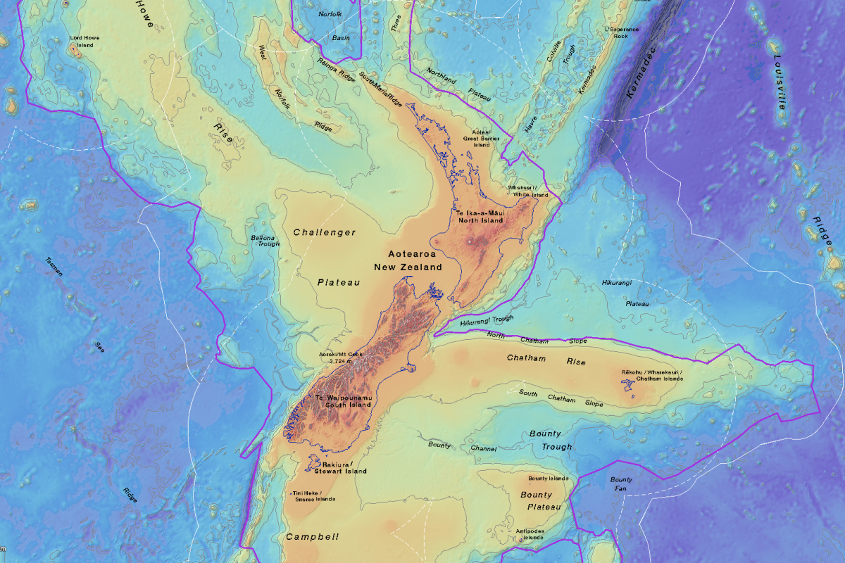
Newly released maps of Zealandia, a massive sunken landmass many have argued should be classified as Earth's eighth continent, are revealing the topography of this underwater land in unprecedented detail. The new trove of data comes from New Zealand research institute GNS Science, which has released two new maps alongside an interactive website designed to give people novel ways to explore the complex geoscience data.

“Users can zoom and pan around different thematic geoscience webmaps of the region,” explains Vaughn Stagpoole, program leader on the development of the new website. “They can readily view and interrogate the maps and turn layers on or off. They can also query features in the layers and generate custom maps of their own.”

These new maps, bathymetric (left) and tectonic, and accompanying interactive website, offer a detailed look at Zealandia

The two new maps comprise of a tectonic map and a bathymetric map. The tectonic map depicts the 1.9-million-square-mile (4.9-million-sq-km) tectonic profile of this extraordinary submerged landmass, while the bathymetric map generates a detailed picture of the ocean floor, depicting the coastlines and territorial limits of this undersea continent.

“We’ve made these maps to provide an accurate, complete and up-to-date picture of the geology of the New Zealand and southwest Pacific area – better than we have had before,” explains geologist Nick Mortimer, lead author on the new maps. “Their value is that they provide a fresh context in which to explain and understand the setting of New Zealand’s volcanoes, plate boundary and sedimentary basins.”

The features of Zealandia some researchers suggest fulfill the criteria of a continent

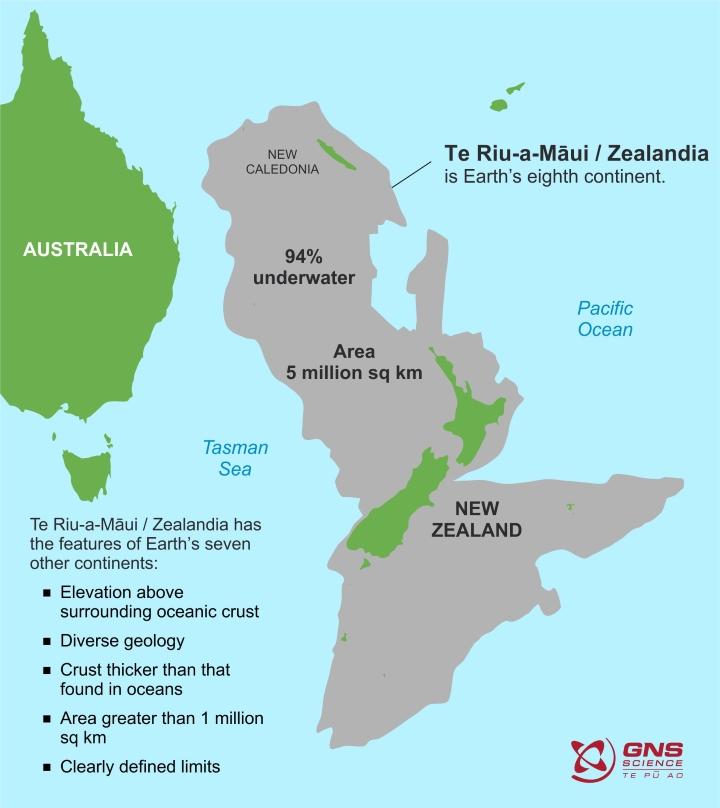
Zealandia is around one-third smaller than the continent of Australia, with New Zealand and New Caledonia its only two above-water landmasses. It is thought it broke off from the supercontinent Gondwana around 80 million years ago and was ultimately submerged beneath the Pacific Ocean a little over 20 million years ago. Currently, almost 95 percent of its total landmass is underwater.

Take a look at the new interactive Zealandia map at GNS Science’s website here.

Source: GNS Science

View gallery - 5 images
3 comments
3 comments
Kpar
OK, how much of this "continent" is less than 400 feet under water? That is not an inconsequential point, as the sea levels were 400 ft lower prior to 12,500 ya. That is within the prehistoric human age, there might have been people there. I'm not saying this was Atlantis (maybe "Pacifis?"). The flooding of the coasts was a worldwide event, and may have been the story behind all the flood myths in world cultures.
Eddy
All the earthquake activity still happening there would suggest the final amount of land left above water, if any is yet to be finalised.
vince
Probably a lot of good old dino bones buried deep underwater on that continent since it sank 20 million years ago which is about 45 million years after the big meteor hit the Earth.