Aircraft

Aeromapper X5 UAV maps terrain and parachutes to the ground when it's done

Aeromapper X5 UAV maps terrain and parachutes to the ground when it's done
The complete Aeromapper X5 package
View 5 Images
A look at some of the electronics and other features that Aeromao added to the stock Skywalker X5 Flying Wing
1/5
A look at some of the electronics and other features that Aeromao added to the stock Skywalker X5 Flying Wing
When the job is done, the plane returns to its take-off point, at which point its engine cuts out and the chute is deployed
2/5
When the job is done, the plane returns to its take-off point, at which point its engine cuts out and the chute is deployed
A screen shot of the Aeromapper's telemetry data, which is wirelessly transmitted to the user's laptop or tablet
3/5
A screen shot of the Aeromapper's telemetry data, which is wirelessly transmitted to the user's laptop or tablet
The Aeromapper package includes a 24-megapixel Sony NEX 7 camera
4/5
The Aeromapper package includes a 24-megapixel Sony NEX 7 camera
The complete Aeromapper X5 package
5/5
The complete Aeromapper X5 package
View gallery - 5 images

While we’re seeing an increasing amount of aerial mapping being performed by purpose-built drone aircraft, a lot of people are no doubt still leery of remotely-piloting what is essentially a little airplane. With such people in mind, Canada’s Aeromao has recently released its Aeromapper X5. The drone is launched by hand, flies and takes photos autonomously, then parachutes back down to the ground.

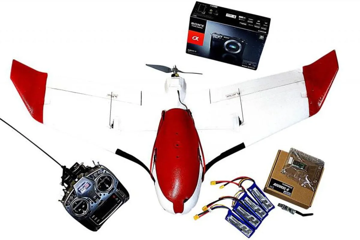
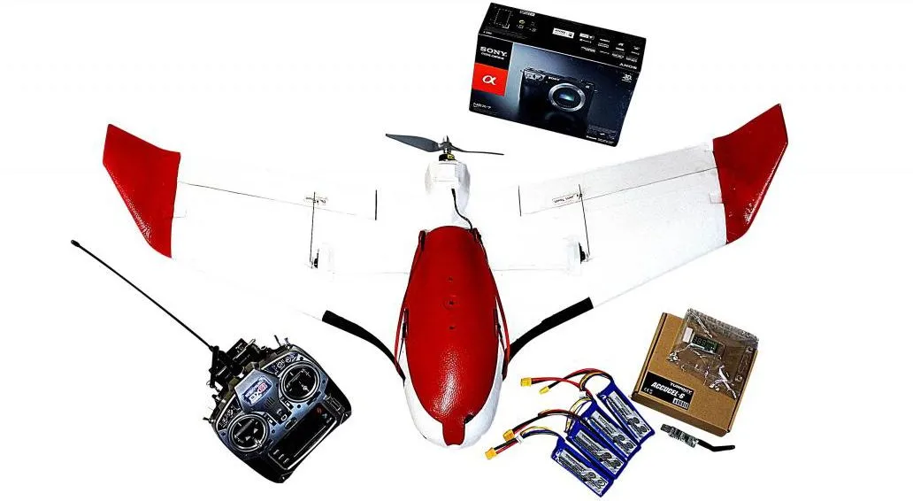
The Aeromapper is a modified version of the already-available Skywalker X5 Flying Wing, a remote-control foam-bodied UAV. Designed for FPV (First Person View) flight, the Skywalker has a built-in “cargo bay” of sorts, for the installation of a user-supplied camera.

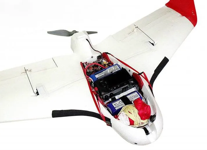
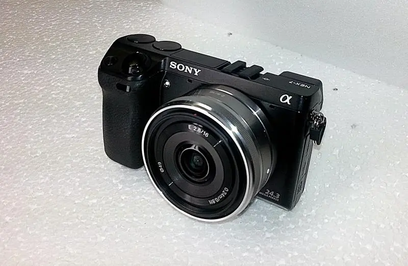
Aeromao has taken that UAV and added features such as carbon fiber reinforcement rods, an Ardupilot Mega 2.6 autopilot, an air-to-ground telemetry system, a landing parachute, and a ground-facing 24-megapixel Sony NEX 7 camera with a pancake lens.

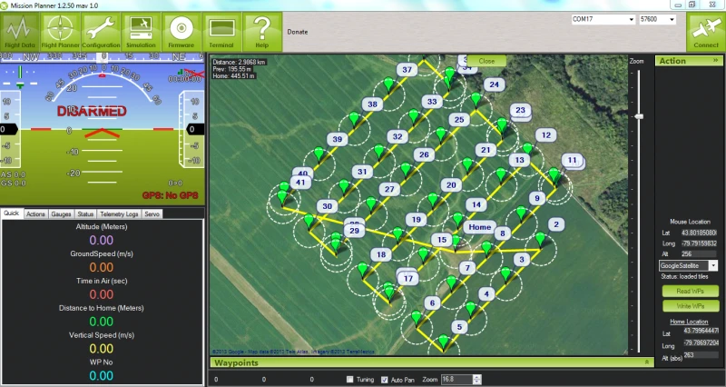
After programming in the coordinates of the geographical area that they wish to map, users just start the Aeromapper up and throw it into the air. It proceeds to fly in a grid pattern over the area, snapping geo-tagged shots at regular intervals as it goes. When the job is done, the plane returns to its take-off point, at which point its engine cuts out and the chute is deployed. During take-off and landing, the camera is protected by a door in the belly of the aircraft, that opens only while mapping is taking place.

When the job is done, the plane returns to its take-off point, at which point its engine cuts out and the chute is deployed

The Aeromapper has a wingspan of 1.18 meters (46.5 in), weighs 1.4 kg (3 lb), and has a maximum cruising speed of 50 km/h (31 mph). One charge of its four 2,200-mAh batteries should be good for 25 to 30 minutes of flight. It can fly in winds blowing at up to 35 km/h (22 mph), and has an autonomous-mode range of 20 km (12 miles) – it can also be manually operated by radio control, but at a shorter range.

It’s an impressive little beast, although one that isn’t aimed at the casual hobbyist – a complete Aeromapper X5 package is priced at 4,700 CAD (about US$4,576).

The drone can be seen in action in the video below.

Source: Aeromao via sUAS News

View gallery - 5 images
4 comments
4 comments
JimRD
No experience necessary except when something breaks. I fly wings all the time and all the time something is breaking or needing tweaking and if you don't have experience with rc aircraft your going to be at a loss. That said I think this is a great idea and package though you can do it yourself with off the shelf products.
christopher
Doesn't do elevation - only takes 2D photos - not really useful.
Mauricio
@JimD: this system is not like a hobby rc airplane, it is totally different in that the computer flies it, and it lands via parachute with a flip of a switch as you saw in the video, so it doesn`t brake like the Rc planes you have.
@christopher: it can certainly do 3D models, since it is a function of the image processing software, not the aircraft itself. The 3D or elevation models, as well as the 2D mapping are created in two steps: first, the capture of the images (where this UAV is aimed to). Second, the process of the images. There are plenty of stand alone image processing softwares out there that can do a lot of things, elevation models & mapping included.
Nguyen An Dinh
How much does this cost?