Mapping
-
 When disaster strikes, drones and robots can be sent into danger zones to scout for survivors. The RoBoa from a student team at ETH Zurich is designed to snake its way through debris that would stop other solutions in their tracks.
 -
 On frequently travelled waterways, it's essential for vessel operators and local authorities to have maps of both bottom and shoreline features. A newly adapted autonomous watercraft could soon make the creation of such maps easier than ever before.
 -
 Since we first got wind of Saildrone's autonomous USVs back in 2018, they've mapped miles of ocean floor, chased hurricanes, and surveyed remote regions. Now the company is adding a new vessel to tackle near-shore mapping and maritime surveillance.
 -
 In July last year, Saildrone launched one its sensor-packed unmanned aquatic drones on a voyage of discovery in the North Pacific, tasked with filling in ocean mapping blanks around Alaska's Aleutian Islands as well as off the coast of California.
 -
 Norway's Argeo has launched the first uncrewed survey and inspection vessel based on the Mariner X platform from Maritime Robotics. The Argus is expected to undertake mapping and inspection operations for offshore wind projects.
 -
 Mapping the inside of cramped, difficult-to-reach areas can be helpful to people such as plant operators, but drones flown in such places could easily crash. The LiDAR- and cage-equipped Elios 3 quadcopter was designed with that challenge in mind.
 -
 Because GPS doesn't work indoors, it can be difficult for robots to determine where they are within a structure. A new system could help, by using a building's existing Wi-Fi access points to guide wheeled or walking robots.
 -
 While AUVs (autonomous underwater vehicles) are invaluable for gathering oceanographic data, they also tend to be fairly large and very expensive. The Hydrus offers a much smaller, less costly alternative, which still packs a lot of punch.
 -
 San Francisco-based aquatic drone-maker Saildrone has returned with a bigger and better version of its unmanned vehicle designed to explore the seas, the newly introduced 72-ft (22-m) Saildrone Surveyor.
 -
 It has been years since Google’s influential Street View left the roads and began to map everything from shopping centers to hiking trails. The device that made this happen was called the Street View Trekker, and Google just revealed an updated model.
 -
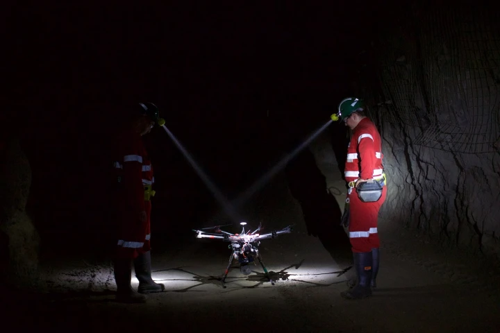 The potential of drones flying through the sky is well documented, but they also hold great potential for environments deep beneath the Earth's surface. Australian-based startup Emesant is developing drone software focused on the autonomous mapping of mines and tunnels.
 -
 Ordinarily, fixed-wing mapping drones either just perform a traditional landing on the ground, or they parachute down to it. However, what if they're being used over the water? Well, that's where Aeromao's new Aeromapper Talon Amphibious drone comes in.
Load More