Using old insurance fire maps, researchers have enabled a machine-learning system to recreate 3D models of neighborhoods that no longer exist. Not only could the technique lead to VR tours of the 'hoods, but it could help study the economic impact of urbanization.
In 1866, a young surveyor named D. A. Sandborn was contracted by the Aetna insurance company to create insurance maps for several cities in Tennessee. That project, along with an atlas he made of the city of Boston, led Sandborn to found a company that still provides insurance companies with maps to this day. In total, the company has created maps that have helped insurance companies evaluate the fire risk to about 12,000 cities and towns in the United States, Mexico, and Canada.
Because the maps have been around so long, they have proven to be an invaluable historical archive; a record of the way urban areas have grown and, in some cases, dwindled in North America for over a century. The map collection was eventually digitized and the Library of Congress now has over 35,000 maps in its online collection.
Working with this digital archive, a doctoral student in geography at The Ohio State University named Yue Lin carried out a study in which he created machine learning tools allowing a computer to comb through the records to extract data such as their footprints, the materials they were built from, and what they were used for.
A whole new approach
"The story here is we now have the ability to unlock the wealth of data that is embedded in these Sanborn fire atlases," said Harvey Miller, Yue's co-author and professor of geography at Ohio State. "It enables a whole new approach to urban historical research that we could never have imagined before machine learning. It is a game changer."
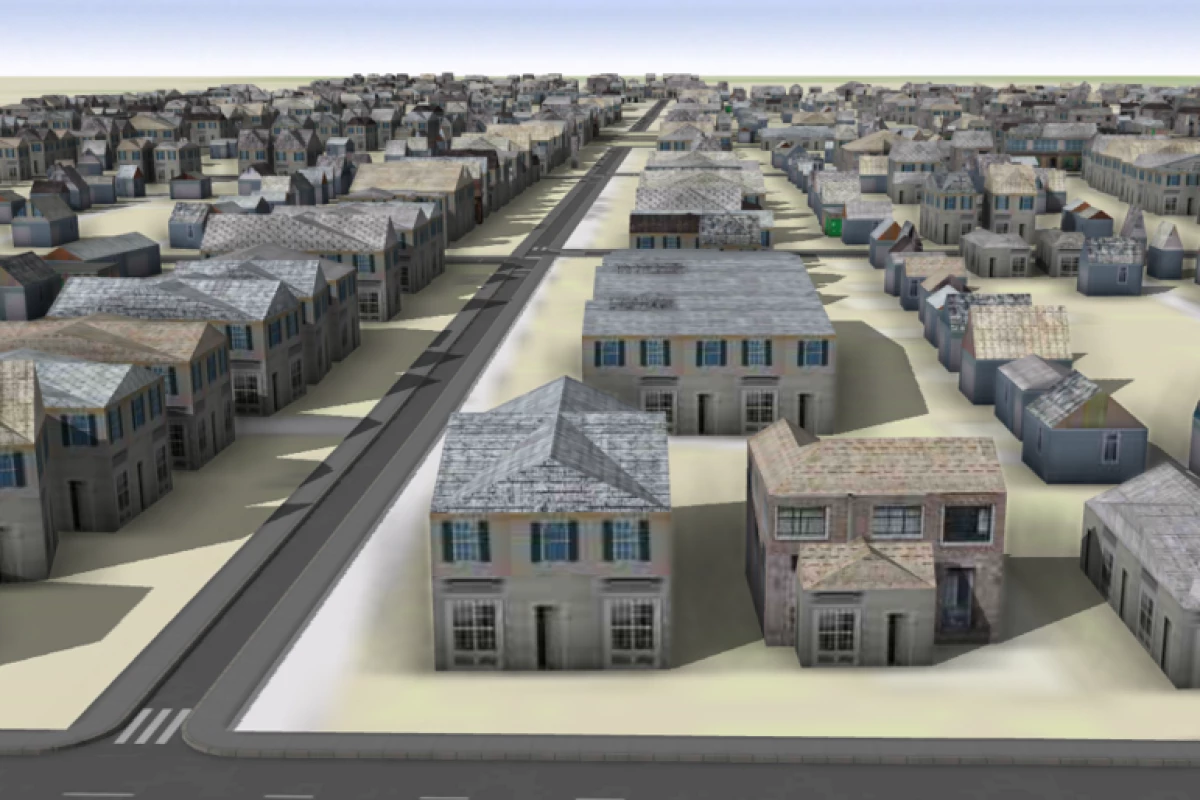
For the study, the researchers had their program examine 13 Sanborn maps from two neighborhoods on the eastern edge of Columbus, OH. Using the data gleaned from the electronic records, the researchers then had the computers create digital models of the two neighborhoods: Hanford Village and Driving Park, which were largely destroyed in the early 1960s to make way for the construction of Interstate 70. The researchers say that nearly 400 buildings were demolished in the two neighborhoods for that project.
According to the study, the machine learning system had an accuracy rate of 90% in recreating the cities, including rendering them in the materials used for their construction.
Beyond entertainment
"The accuracy was impressive. We can actually get a visual sense of what these neighborhoods looked like that wouldn’t be possible in any other way," said Miller. "We want to get to the point in this project where we can give people virtual reality headsets and let them walk down the street as it was in 1960 or 1940 or perhaps even 1881."
In addition to the potential entertainment value, the researchers say their technique could provide both valuable economic and environmental information through such data points as businesses lost due to development projects, and how such projects might alter the way the sun is absorbed in urban areas and lead to urban heat islands.
"There’s a lot of different types of research that can be done. This will be a tremendous resource for urban historians and a variety of other researchers," Miller said. "Making these 3D digital models and being able to reconstruct buildings adds so much more than what you could show in a chart, graph, table or traditional map. There’s just incredible potential here."
The research has been published in the journal PLOS ONE.
Source: The Ohio State University