Environment

Antarctica's Doomsday Glacier "hanging on by its fingernails"

Antarctica's Doomsday Glacier "hanging on by its fingernails"
Research vessel in front of the Thwaites Glacier
View 3 Images
Research vessel in front of the Thwaites Glacier
1/3
Research vessel in front of the Thwaites Glacier
3D map of the seafloor in front of the Thwaites Glacier
2/3
3D map of the seafloor in front of the Thwaites Glacier
Scientists have used an underwater research vessel to map the seafloor in front of the Thwaites Glacier
3/3
Scientists have used an underwater research vessel to map the seafloor in front of the Thwaites Glacier
View gallery - 3 images

Scientists have deployed an advanced robotic submarine to gain a new perspective on the Thwaites Glacier in West Antarctica, with the groundbreaking seafloor imagery highlighting its precarious state in concerning new detail. The research reveals the glacier has undergone spurts of rapid retreat in the past that scientists now expect to see again in the future, which could have important ramifications for global sea levels.

Around the size of Florida, the Thwaites Glacier is known as the “Doomsday Glacier” owing to its status as one of the most unstable glaciers in Antarctica. Its melt rate is accelerating, with its outflow speed doubling in the last 30 years, and some studies suggesting it could be just years away from a complete collapse. Were that to happen, the amount of water released from the giant ice stream would be enough to drive up global sea levels by several meters.

The Thwaites Glacier is known to be in a phase of fast retreat, but new research led by marine geophysicists at the University of South Florida reveals this might be occurring faster than we realize. In 2019, the team sent an advanced underwater robot loaded with imaging sensors on a 20-hour mission to map the seabed in front of the glacier.

Scientists have used an underwater research vessel to map the seafloor in front of the Thwaites Glacier

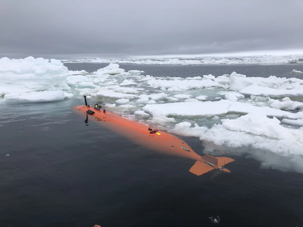
Extreme summer conditions and a lack of sea ice enabled scientists to access this section of the seafloor for the first time ever. This bears a resemblance to another research expedition from 2020 in which scientists sent a robotic sub to inspect the Thwaites Glacier’s grounding line, the point where the seafloor meets the ice, to assess its stability.

This new study focused on the geography of the seafloor in front of the glacier, mapping a region around the size of Houston. This revealed features previously unknown to scientists, most notably a set of 160 parallel ridges formed as the glacier’s grounding line retreated and bobbed upwards and downwards with the shifting tides.

3D map of the seafloor in front of the Thwaites Glacier

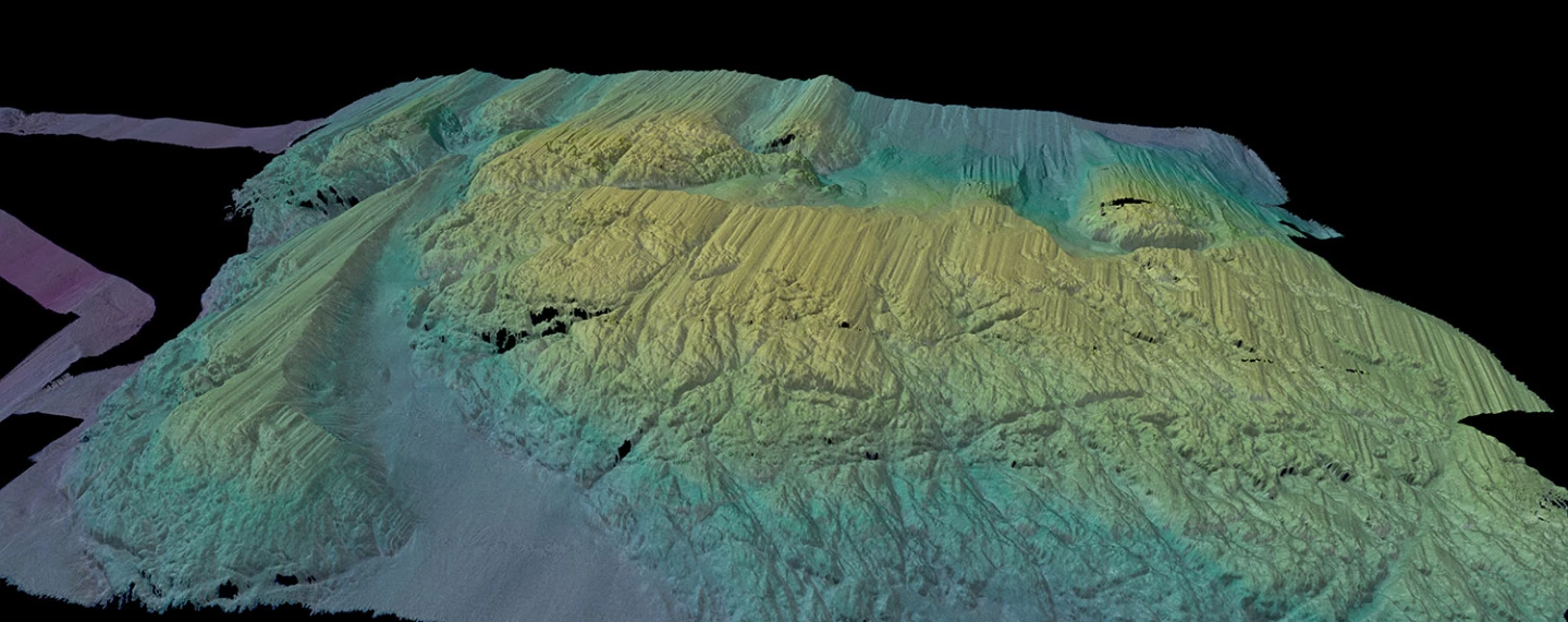
“It’s as if you are looking at a tide gauge on the seafloor,” said Alastair Graham, who led the study. “It really blows my mind how beautiful the data are.”

Matching these ridge formations with tidal cycles for the region revealed that each of these ribs must have been formed every day, enabling the team to draw conclusions about the rate of retreat. They calculate that at some point in the last two centuries, in a duration of five or six months, the glacier retreated at a rate of around 2.1 km (1.3 miles). This is twice the retreat rate measured by satellites between 2011 and 2019.

“Thwaites is really holding on today by its fingernails, and we should expect to see big changes over small timescales in the future – even from one year to the next – once the glacier retreats beyond a shallow ridge in its bed,” said marine geophysicist and study co-author, Robert Larter, from the British Antarctic Survey.

The research was published in the journal Nature Geoscience.

Source: University of South Florida

View gallery - 3 images
10 comments
10 comments
darkcook
Sorry, but I just can't buy that a chunk of ice the size of Florida, should it melt, would "drive up global sea levels by several meters." It just doesn't seem like the order of magnitude is correct on this one. I could be wrong and I haven't calculated any numbers. But with 70% of the earth's surface covered with water, it just seems like it isn't going to matter. If they had said inches, I'd be skeptical, but could buy it. Meters??? Be afraid people, be very afraid!
Robt
‘Were that to happen, the amount of water released from the giant ice stream would be enough to drive up global sea levels by several meters.’
Given the severity of the stated consequence, is it possible to show the math behind the statement?

rpark
...it's too late to stop the melt feedback loop now .. if you have a property in FL, sell it.
MeToo
So, in other words, this has been retreating for a long time. Way past the time of Al gore.
Rustgecko
"Were that to happen (collapse), the amount of water released from the giant ice stream would be enough to drive up global sea levels by several meters."

Really? The Thwaites glacier is 500,000 km3. That sounds a lot. However, if you do the sums it would add one-third of one percent (0.3%) to the volume of the oceans. Would it really increase the ocean height by metres? Anyone want to take a bet?

I suspect that this quote is there for journalistic effect along with "Doomsday Glacier", rather than anything that a scientific study has calculated.
schutzhund
Anyone?
Marie Byrd Mantle Plume
Anyone?
PocoPete
Seawater of all oceans covers an area of approximately 361,000,000 km^2,
The volume of the ice above sea level of Thwaites Glacier is 258,000 km^3,

So to find the maximum possible sea level rise we dived the glacier volume by the ocean area as follows:

258,000 km^3 / 361,000,000 km^2 = 0.00071468 km = 0.715 m sea level rise.

This is not "several meters" as mentioned in the article but it is an amount that would be disastrous for many coastlines.
Please check my math. Thanks.
ljaques
Another thing which could be done to mitigate AGWK is to ask those 91 newly discovered subglacial volcanoes in Antarctica (2017) to cool themselves down a bit.
TpPa
it takes 2121 Florida's to cover all the ocean's. So how thick is the glacier on average - wide - & long also. Good luck really knowing that
MKO
Fresh water evaporates more quickly than salt water so if my newbie Climate Engineering Theory is correct the rise in diluted sea water SHOULD result in more evaporation globally and during the cooler parts of the year will cause more snow to drop. If enough years of continual snow accumulation occurs, then the new ice age will fire up just like clock work. In 80,000 years we'll all be griping about how damn cold it it, but we'll have more beach front property to enjoy.