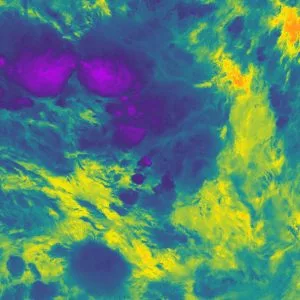
Using advanced infrared imaging technology aboard an Earth-orbiting satellite, scientists have measured the coldest temperature of a storm cloud on record at a chilling −111.2 °C. The severe thunderstorm barreled across the Pacific in late 2018 where it grew to an exceptionally high altitude and pushed into the stratosphere, an event researchers say is becoming more and more common.
The data was collected by the NOAA-20 satellite as it passed over a southwestern patch of the Pacific ocean in December 2018, several hundreds miles off the coast of Nauru. These types of satellites use infrared sensors to measure the temperature of the Earth and the atmosphere, and when they encounter thunderstorms that reach high altitude, they often collect very cold readings owing to the extremely chilly air far above sea level.
But the reading returned by the NOAA-20 satellite and its onboard Visible Infrared Imaging Radiometer Suite wasn't quite like anything scientists had seen before. The measurement of -168 °F (−111.2 °C) is the coldest known measurement of a storm cloud, and the coldest temperature recorded by a satellite.
The reason behind these unprecedented readings is the incredible power within this particular storm, which pushed it through the lower section of the Earth's atmosphere, known as the troposphere. Normally, when a storm reaches the top of the troposphere, it flattens out into an anvil shape. But such was the severity of this storm that it penetrated the stratosphere, reaching 20.5km (12.8mi) above sea level. Such events are called overshooting tops.

The readings were made possible by recent advances in infrared sensors, which can measure temperatures in these overshooting top turrets at increasingly more detailed spatial scales. While they haven't quite reached the same lows, the scientists say that clusters of similarly low temperatures have been detected in recent years, indicating these events are becoming more frequent.
"This storm achieved an unprecedented temperature that pushes the limits of what current satellite sensors are capable of measuring," says study author Dr Simon Proud. "We found that these really cold temperatures seem to be becoming more common – with the same number of extremely cold temperatures in the last three years as in the 13 years before that. This is important, as thunderstorms with colder clouds tend to be more extreme, and more hazardous to people on the ground due to hail, lightning and wind. We now need to understand if this increase is due to our changing climate or whether it is due to a “perfect storm” of weather conditions producing outbreaks of extreme thunderstorms in the last few years."
The research was published in the journal Geophysical Research Letters.


