Space

India pulls in the sharpest Moon surface images ever taken from orbit

View 6 Images
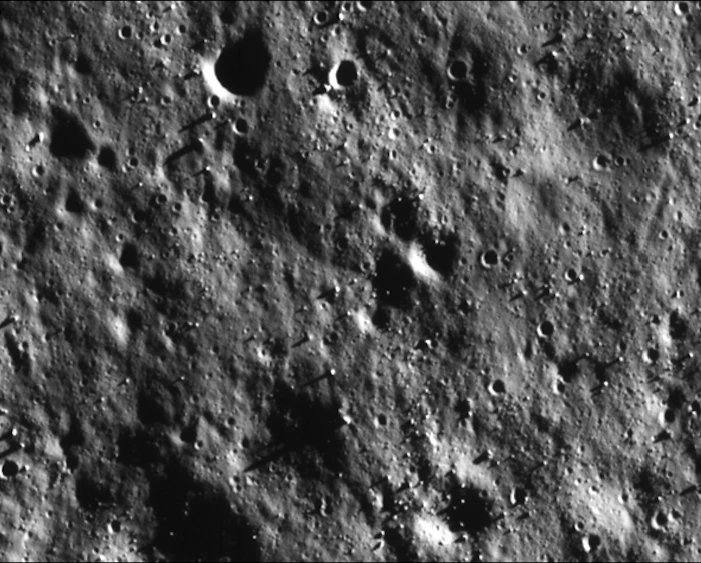
The surface of the Moon, as seen by the Chandrayaan-2 from a distance of 100 km
ISRO
Image of the lunar surface taken from the ISRO's Chandrayaan-2 spacecraft
ISRO
Images from the ISRO's Chandrayaan-2 spacecraft show the surface in detail that is unparalleled for a lunar orbiter
ISRO
Images relayed from the ISRO's Terrain Mapping Camera of the lunar surface
ISRO
Image depicting craters in the Moon’s north polar region, taken by the ISRO's Terrain Mapping Camera
ISRO
Image depicting craters in the Moon’s north polar region, taken by the ISRO's Terrain Mapping Camera
ISRO
The surface of the Moon, as seen by the Chandrayaan-2 from a distance of 100 km
ISRO
View gallery - 6 images

Things haven’t quite gone to plan for India's Chandrayaan-2 mission, with the team losing the spacecraft’s Vikram lander following a touchdown attempt last month. But there is still plenty of science to come as the probe continues to circle the Moon, with the latest imagery relayed by the orbiting spacecraft revealing the lunar surface in unparalleled detail.

Chandrayaan-2 is the Indian Space Research Organisation’s (ISRO) second ever mission to the Moon and is built to help us understand its makeup by studying its topography, chemical composition and distribution of minerals. The spacecraft will do so through eight different scientific instruments, including a pair of imaging devices in the form of the Terrain Mapping Camera 2 and the Orbiter High Resolution Camera (ORHC).

The ORHC is in the process of snapping ultra-high-resolution images of the lunar surface over the course of two orbits. The latest transmission reveals the terrain in the "sharpest images ever from a lunar orbiter platform," according to ISRO.

Image of the lunar surface taken from the ISRO's Chandrayaan-2 spacecraft
ISRO

Taken on September 5, the image depicts a region of the Moon within an impact crater called Boguslawsky, which measures 14 km (8.7 mi) across. Zeroing in on different areas of the image reveal boulders, small craters and other surface details with a pixel resolution of 30 cm (12 in), taken from a distance of 100 km (62 mi).

Images from the ISRO's Chandrayaan-2 spacecraft show the surface in detail that is unparalleled for a lunar orbiter
ISRO

These follow earlier images relayed from the Terrain Mapping Camera in August depicting craters in the Moon’s north polar region. The Vikram lander, however, remains incommunicado. The team was able to pinpoint the site of its crash-landing last month, and continues its efforts to re-establish contact.

Source: ISRO

View gallery - 6 images
  • Facebook
  • Twitter
  • Flipboard
  • LinkedIn
5 comments
sgdeluxedoc
Great pictures. but.. they're just rocks and craters. Nothing too exciting.. considering, that with that high of a resolution they could, if predisposed, use it to finally solve some of the many mysteries on the moon. Namely, OOP (out of place) artifacts like that 2000 foot tall tower, or "pipe"that's been seen a number of times, and other oddities, ships, and OOP artifacts, that have been filmed by various nasa orbiters and astronauts (purportedly, since they were all classified or brushed out, but the whistleblowers credibility is very high).
I don't know if India would do the same though.. but with resolution that high they really ought to settle these matters once and for all.
Douglas Rogers
This is about the same as Google Earth.
Gx Marius
here we go, is going to start soon!
b@man
Old texts talk about a time before the moon was here:)
WB
Sharpest ever? How about the ones taken straight from the moon surface ?