Holiday Destinations

A tale of ice and fire: Time travel in Iceland

A tale of ice and fire: Time travel in Iceland
About 11 percent of Iceland is covered in glaciers with a full eight percent coming from the Vatnajökull glacier in the southeast of the country. With an area of 8,300 sq km (3205 sq mi), it has the same mass as all of the glaciers on mainland Europe put together. This shot was taken at the Jökulsárlón glacial lagoon, a spot where the massive glacier has an outlet, or an area where the giant ice lake flows outwards. This wall is the site of regular calving, where chunks of ice drop into the lagoon to become icebergs.
View 23 Images
About 11 percent of Iceland is covered in glaciers with a full eight percent coming from the Vatnajökull glacier in the southeast of the country. With an area of 8,300 sq km (3205 sq mi), it has the same mass as all of the glaciers on mainland Europe put together. This shot was taken at the Jökulsárlón glacial lagoon, a spot where the massive glacier has an outlet, or an area where the giant ice lake flows outwards. This wall is the site of regular calving, where chunks of ice drop into the lagoon to become icebergs.
1/23
About 11 percent of Iceland is covered in glaciers with a full eight percent coming from the Vatnajökull glacier in the southeast of the country. With an area of 8,300 sq km (3205 sq mi), it has the same mass as all of the glaciers on mainland Europe put together. This shot was taken at the Jökulsárlón glacial lagoon, a spot where the massive glacier has an outlet, or an area where the giant ice lake flows outwards. This wall is the site of regular calving, where chunks of ice drop into the lagoon to become icebergs.
The lagoon is fed by the glacier, and empties out into the North Atlantic ocean where a black-sand beach created from the powdering of volcanic rock receives a regular barrage of ice chunks.
2/23
The lagoon is fed by the glacier, and empties out into the North Atlantic ocean where a black-sand beach created from the powdering of volcanic rock receives a regular barrage of ice chunks.
At another outlet of Vatnajökull glacier, visitors are invited to don crampons and walk out on the icy surface. The glacier measures nearly 1,000 m (3,280 ft) thick at its deepest point, with an average thickness of 500 m (1640 ft). It's total ice volume is estimated at 3,300 cubic km (791 cubic mi). That's changing fast as the warming climate accelerates the glacier's retreat. Many of Icleand's glaciers are melting at a rate of about one meter per year, with an even more accelerated rate seen in outlets like this one.
3/23
At another outlet of Vatnajökull glacier, visitors are invited to don crampons and walk out on the icy surface. The glacier measures nearly 1,000 m (3,280 ft) thick at its deepest point, with an average thickness of 500 m (1640 ft). It's total ice volume is estimated at 3,300 cubic km (791 cubic mi). That's changing fast as the warming climate accelerates the glacier's retreat. Many of Icleand's glaciers are melting at a rate of about one meter per year, with an even more accelerated rate seen in outlets like this one.
The glacier has a series of plummeting crevasses, caused when different parts of the flowing ice move at different speeds or hit large obstacles like boulders. It also has areas filled with "rotten ice," spots on the glacier where the ice has been exposed to sunlight and has weakened due to cracks. It forms a crumbly type of ice that would be useless when struck with an ice pick to stop a climber's fall into an unseen crevasse.
4/23
The glacier has a series of plummeting crevasses, caused when different parts of the flowing ice move at different speeds or hit large obstacles like boulders. It also has areas filled with "rotten ice," spots on the glacier where the ice has been exposed to sunlight and has weakened due to cracks. It forms a crumbly type of ice that would be useless when struck with an ice pick to stop a climber's fall into an unseen crevasse.
Iceland's most famous volcano, Eyjafjallajökull (whose pronunciation locals enjoy hearing tourists mangle) erupted in 2010, sending a plume of ash into the sky that shut down airports around Europe. But that's just one of the country's fiery mountains, which ring in at an impressive 130 if you count both active and dormant volcanoes. On the western side of the country, visitors can wander along a newly-built boardwalk through an eerie landscape to explore the Grabok craters, a series of three craters known as scoria cones believed to be around 3,500 years old.
5/23
Iceland's most famous volcano, Eyjafjallajökull (whose pronunciation locals enjoy hearing tourists mangle) erupted in 2010, sending a plume of ash into the sky that shut down airports around Europe. But that's just one of the country's fiery mountains, which ring in at an impressive 130 if you count both active and dormant volcanoes. On the western side of the country, visitors can wander along a newly-built boardwalk through an eerie landscape to explore the Grabok craters, a series of three craters known as scoria cones believed to be around 3,500 years old.
Another of the Grabrok craters.
6/23
Another of the Grabrok craters.
With a hot volcanic base and a cold glacial cap, it's not hard to understand what Iceland has a lot of – water. In particular, it has a series powerful flowing rivers that carve the landscape and create a collection of jaw-dropping waterfalls. There are at least 30 well-known waterfalls on the tourist trail and countless others that tumble off cliffs behind farmhouses on all parts of the island. This one, Godafoss, is in the northern part of the country. It was formed by the river Skjálfandafljót's flow over a 7000-year-old lava field, which created a canyon measuring about 100 m (328 ft) wide.
7/23
With a hot volcanic base and a cold glacial cap, it's not hard to understand what Iceland has a lot of – water. In particular, it has a series powerful flowing rivers that carve the landscape and create a collection of jaw-dropping waterfalls. There are at least 30 well-known waterfalls on the tourist trail and countless others that tumble off cliffs behind farmhouses on all parts of the island. This one, Godafoss, is in the northern part of the country. It was formed by the river Skjálfandafljót's flow over a 7000-year-old lava field, which created a canyon measuring about 100 m (328 ft) wide.
While Iceland has plenty of areas where steam shoots from the ground, this particular patch of mist comes from the churning water just before Dettifloss, Europe's highest-volume waterfall. Five hundred cubic meters of water per second (17,657 cubic ft) plunge 45 m (148 ft) downward after tumbling over the edge. Dettifoss is 100 m (328 ft) wide and was once considered being harnessed for a hydroelectric plant. The plans were scrapped when it was found that the volcanic rock through which it flows was too porous to create the needed reservoir.
8/23
While Iceland has plenty of areas where steam shoots from the ground, this particular patch of mist comes from the churning water just before Dettifloss, Europe's highest-volume waterfall. Five hundred cubic meters of water per second (17,657 cubic ft) plunge 45 m (148 ft) downward after tumbling over the edge. Dettifoss is 100 m (328 ft) wide and was once considered being harnessed for a hydroelectric plant. The plans were scrapped when it was found that the volcanic rock through which it flows was too porous to create the needed reservoir.
Speaking of porous volcanic rock, this image shows Hraunfossar waterfall, whose name comes from the Icelandic word for lava ("hraun"). The water here literally pours from the side of a riverbank as it flows from lava tubes created when one of the volcanoes lying under the glacier Langjökull erupted around 800 CE.
9/23
Speaking of porous volcanic rock, this image shows Hraunfossar waterfall, whose name comes from the Icelandic word for lava ("hraun"). The water here literally pours from the side of a riverbank as it flows from lava tubes created when one of the volcanoes lying under the glacier Langjökull erupted around 800 CE.
The multi-level Gullfoss waterfall was created when a flash flood raged through this area of southern Iceland during the last ice age. The force of water carved away soft sedimentary rock while leaving hard layers of basalt lava called dolerite on either side of the flow. The water that feeds Gullfoss today comes from the Lángjökull glacier about 40 km (25 mi) away. Because glacial water has a fair amount of sediment in it, it lends water a brownish tint, and in fact, Gullfoss is often called the "Golden Falls" due to this coloration.
10/23
The multi-level Gullfoss waterfall was created when a flash flood raged through this area of southern Iceland during the last ice age. The force of water carved away soft sedimentary rock while leaving hard layers of basalt lava called dolerite on either side of the flow. The water that feeds Gullfoss today comes from the Lángjökull glacier about 40 km (25 mi) away. Because glacial water has a fair amount of sediment in it, it lends water a brownish tint, and in fact, Gullfoss is often called the "Golden Falls" due to this coloration.
At 122 m (400 ft) high, Háifoss waterfall (or "Tall Falls") seen here, was traditionally known as Iceland's second biggest waterfall after the 196-m-high Glymur waterfall. However both cataracts lost their titles when a waterfall discovered by the retreat of the Morsárjökull glacier, was found to be 227 m (745 ft) high in 2011. Nonetheless, Haifoss still impresses and the opposing banks give a great vantage point from which to take it in. Haifoss is situated near Hekla volcano, which many scientists believe is due to explode in the near future.
11/23
At 122 m (400 ft) high, Háifoss waterfall (or "Tall Falls") seen here, was traditionally known as Iceland's second biggest waterfall after the 196-m-high Glymur waterfall. However both cataracts lost their titles when a waterfall discovered by the retreat of the Morsárjökull glacier, was found to be 227 m (745 ft) high in 2011. Nonetheless, Haifoss still impresses and the opposing banks give a great vantage point from which to take it in. Haifoss is situated near Hekla volcano, which many scientists believe is due to explode in the near future.
Steam rising from the ground is a regular site in Iceland, a country that harnesses the volcanic activity beneath the surface for geothermal energy. Approximately nine out of 10 houses in Iceland are directly heated with the hot underground water that runs throughout the country and geothermal sources are used in the production of about 30 percent of Iceland's electricity.
12/23
Steam rising from the ground is a regular site in Iceland, a country that harnesses the volcanic activity beneath the surface for geothermal energy. Approximately nine out of 10 houses in Iceland are directly heated with the hot underground water that runs throughout the country and geothermal sources are used in the production of about 30 percent of Iceland's electricity.
This steam vent, mounded with rocks, is found at Hverir, an area at the base of the Námafjall volcano in northeast Iceland. The popular tourist attraction features boiling pits of multi-hued mud and sulphur-spewing steam vents called fumaroles. Such vents can produce steam with temperatures as high as 280° F (138° C). Iceland's national power company, Landsvirkjun, uses the geothermal resources of this region to produce 3 MW of electricity.
13/23
This steam vent, mounded with rocks, is found at Hverir, an area at the base of the Námafjall volcano in northeast Iceland. The popular tourist attraction features boiling pits of multi-hued mud and sulphur-spewing steam vents called fumaroles. Such vents can produce steam with  temperatures as high as 280° F (138° C). Iceland's national power company, Landsvirkjun, uses the geothermal resources of this region to produce 3 MW of electricity.
In the southern part of the island, geothermal activity created the Great Geysir, or Stori-Geysir. That water rocket shot plumes as high as 60-80 m (197-262 ft) but has been dormant since 1916. Instead, visitors to the area can check out this geyser, known as Strokkur (The Churn), which shoots up in the air about every five minutes and can reach heights of 30 m (8 ft). The water in the geyser system is heated by magma to about 240° C (464° F) and comes from a depth of about 1 km (0.6 mi). The English word geyser actually comes from the Icelandic word geysir, which means "gusher."
14/23
In the southern part of the island, geothermal activity created the Great Geysir, or Stori-Geysir. That water rocket shot plumes as high as 60-80 m (197-262 ft) but has been dormant since 1916. Instead, visitors to the area can check out this geyser, known as Strokkur (The Churn), which shoots up in the air about every five minutes and can reach heights of 30 m (8 ft). The water in the geyser system is heated by magma to about 240° C (464° F) and comes from a depth of about 1 km (0.6 mi). The English word geyser actually comes from the Icelandic word geysir, which means "gusher."
When lava cools and turns into basalt, it can crack along regular joints and make impressive columns such as those seen at the Giant's Causeway in Ireland or, to a lesser extend, here at the black sand beach in southern Icleand known as Reynisfjara.
15/23
When lava cools and turns into basalt, it can crack along regular joints and make impressive columns such as those seen at the Giant's Causeway in Ireland or, to a lesser extend, here at the black sand beach in southern Icleand known as Reynisfjara.
When lava flows hit a turbulent water source, such as the ocean at Reynisfjara, the resulting pattern can be slightly more erratic, as this close-up of a cave entrance on the beach shows.
16/23
When lava flows hit a turbulent water source, such as the ocean at Reynisfjara, the resulting pattern can be slightly more erratic, as this close-up of a cave entrance on the beach shows.
While much of the Icelandic landscape is desolate, Lake Myvatn in the north of the country provides an oasis for life, particularly bird life. The lake was formed about 2,300 years ago from – you guessed it – a volcanic eruption, and today is the fourth largest lake in the country. It is fed with cold-water springs that bring nutrients from deep underground and attract thousands of midges (its name actually means "Lake Midge"). Those insects, in turn, bring a plethora of bird life to the lake, making it the home to more species of birds than anywhere in Europe.
17/23
While much of the Icelandic landscape is desolate, Lake Myvatn in the north of the country provides an oasis for life, particularly bird life. The lake was formed about 2,300 years ago from – you guessed it – a volcanic eruption, and today is the fourth largest lake in the country. It is fed with cold-water springs that bring nutrients from deep underground and attract thousands of midges (its name actually means "Lake Midge"). Those insects, in turn, bring a plethora of bird life to the lake, making it the home to more species of birds than anywhere in Europe.
There is a popular joke in Iceland: "What do you do if you get lost in an Icelandic forest? Stand up." The country has a noticeable lack of trees because early settlers cut them down for building, fuel and to create grazing lands. After that, erosion set it. Today, about five million woodland plants are put in each year to bring back the forests, but due to the country's climate and lack of sunlight for much of the year, it's slow going. This color-manipulated photo shows a small forest on a peninsula in Lake Myvatn filled with native birch trees, planted by the husband and wife who used to own the land before they donated it to the state.
18/23
There is a popular joke in Iceland: "What do you do if you get lost in an Icelandic forest? Stand up." The country has a noticeable lack of trees because early settlers cut them down for building, fuel and to create grazing lands. After that, erosion set it. Today, about five million woodland plants are put in each year to bring back the forests, but due to the country's climate and lack of sunlight for much of the year, it's slow going. This color-manipulated photo shows a small forest on a peninsula in Lake Myvatn filled with native birch trees, planted by the husband and wife who used to own the land before they donated it to the state.
Dominating the view from much of the area around Lake Myvatn is this lunar-like landscape, the Hverfell crater. Hverfell (or Hverfjall as it's sometimes called) is what's left behind after a volcano exploded about 3,000 years ago. The crater measures about 140 meters (460 ft) deep and has a diameter of approximately 1,000 meters (3,300 ft). It's known as a tephra cone, which refers to the hard ashy material that makes up its surface.
19/23
Dominating the view from much of the area around Lake Myvatn is this lunar-like landscape, the Hverfell crater. Hverfell (or Hverfjall as it's sometimes called) is what's left behind after a volcano exploded about 3,000 years ago. The crater measures about 140 meters (460 ft) deep and has a diameter of approximately 1,000 meters (3,300 ft). It's known as a tephra cone, which refers to the hard ashy material that makes up its surface.
When driving along the southern edge of the country, much of landscape is dominated by fields filled with ancient dried lava like this, shown in a color-altered photo. Moss and lichen are the first plant life forms to take root on the otherwise barren surface, breaking down the lava into soil on which more advanced plants and trees may someday grow.
20/23
When driving along the southern edge of the country, much of landscape is dominated by fields filled with ancient dried lava like this, shown in a color-altered photo. Moss and lichen are the first plant life forms to take root on the otherwise barren surface, breaking down the lava into soil on which more advanced plants and trees may someday grow.
This picture was taken from the 120-m-high (394 ft) Dyrhólaey peninsula in the south of the country. The peninsula was formed partly from an undersea eruption approximately 80,000 years ago. The tall formation on the beach, as well as the distant sea stacks in the upper right, known as Reynisdrangar, were formed as softer stone was eroded around harder basaltic compositions. The legend of Reynisdrangar says that two trolls were pulling a three-masted ship to shore when the sun rose and turned them to stone.
21/23
This picture was taken from the 120-m-high (394 ft) Dyrhólaey peninsula in the south of the country. The peninsula was formed partly from an undersea eruption approximately 80,000 years ago. The tall formation on the beach, as well as the distant sea stacks in the upper right, known as Reynisdrangar, were formed as softer stone was eroded around harder basaltic compositions. The legend of Reynisdrangar says that two trolls were pulling a three-masted ship to shore when the sun rose and turned them to stone.
One of the most popular reasons tourists visit Iceland is to try to glimpse the northern lights, a colorful phenomenon that occurs when charged particles from the sun collide with our atmosphere. During the summer months, it's extremely rare to see the light show because of the near constant sunlight. So as an alternative, visitors can head to Aurora Reykjavik where, after exploring the science and folklore behind the phenomenon, they can strap on a virtual reality headset and experience the aurorae in the next best way short of seeing it live.
22/23
One of the most popular reasons tourists visit Iceland is to try to glimpse the northern lights, a colorful phenomenon that occurs when charged particles from the sun collide with our atmosphere. During the summer months, it's extremely rare to see the light show because of the near constant sunlight. So as an alternative, visitors can head to Aurora Reykjavik where, after exploring the science and folklore behind the phenomenon, they can strap on a virtual reality headset and experience the aurorae in the next best way short of seeing it live.
The color of an iceberg can tell you a lot. In this berg, the stripes of black represent volcanic eruptions that spewed ash on top of ice over time. The blueish tint to the ice shows that the iceberg flipped over recently. That's because when the ice first calves from the glacier, it is compacted so tightly that light coming through it takes on a blue hue. After the iceberg flips over, as they do from getting top heavy, the ice eventually turns white as the sun creates tiny cracks in its structure.
23/23
The color of an iceberg can tell you a lot. In this berg, the stripes of black represent volcanic eruptions that spewed ash on top of ice over time. The blueish tint to the ice shows that the iceberg flipped over recently. That's because when the ice first calves from the glacier, it is compacted so tightly that light coming through it takes on a blue hue. After the iceberg flips over, as they do from getting top heavy, the ice eventually turns white as the sun creates tiny cracks in its structure.
View gallery - 23 images

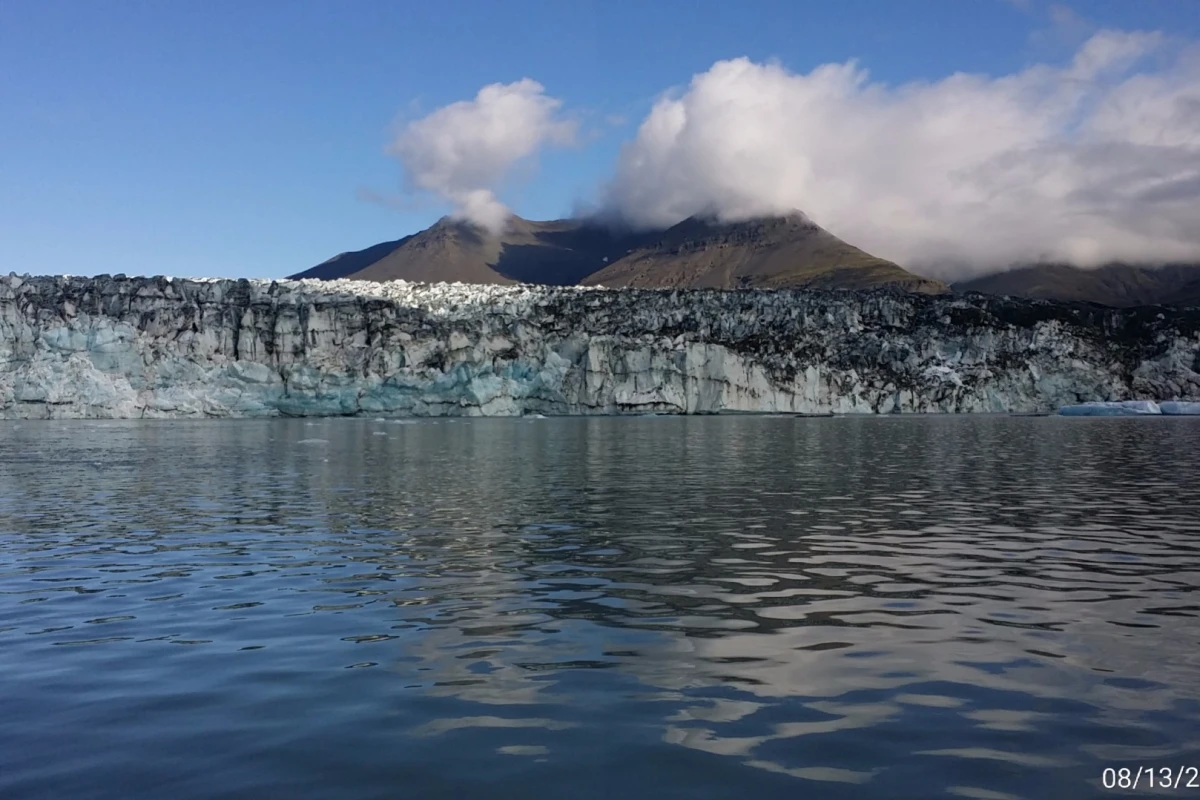
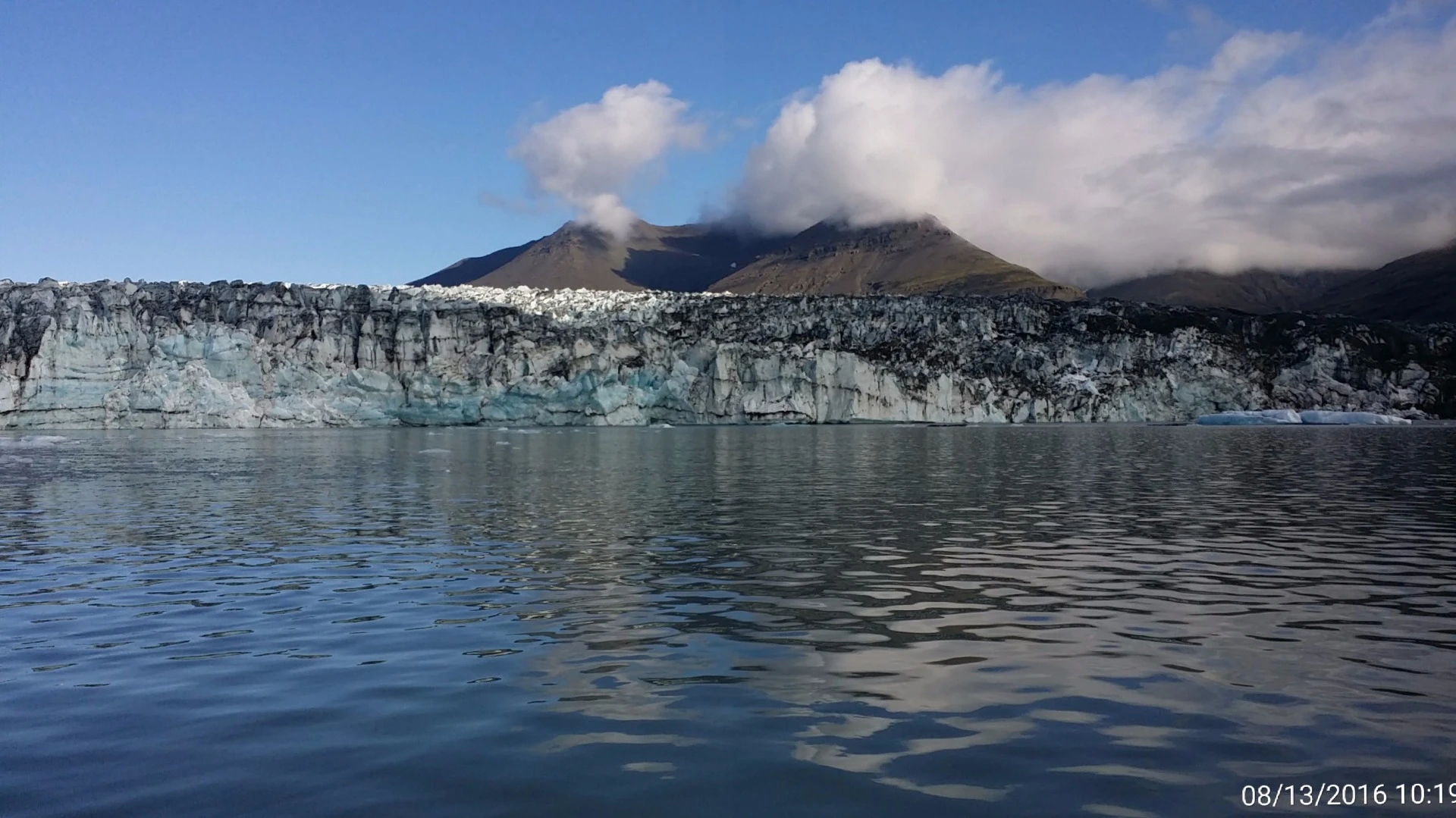
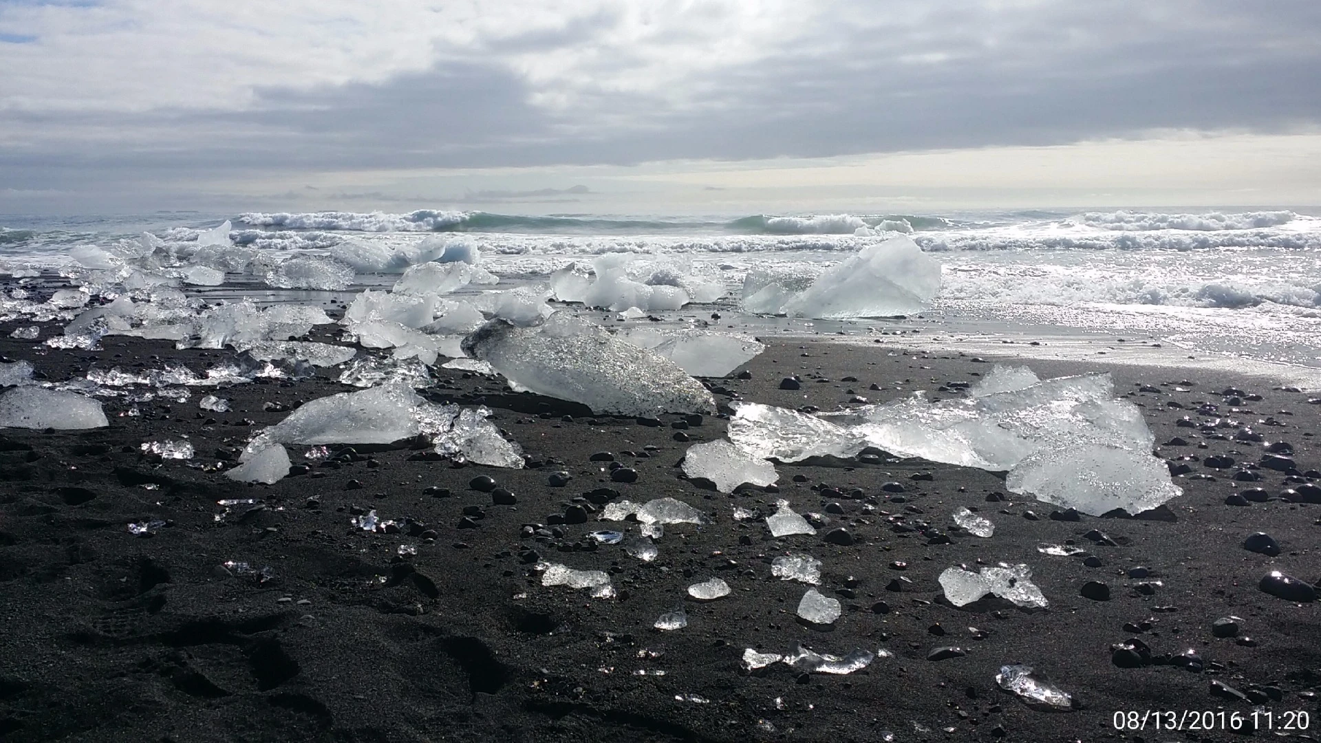
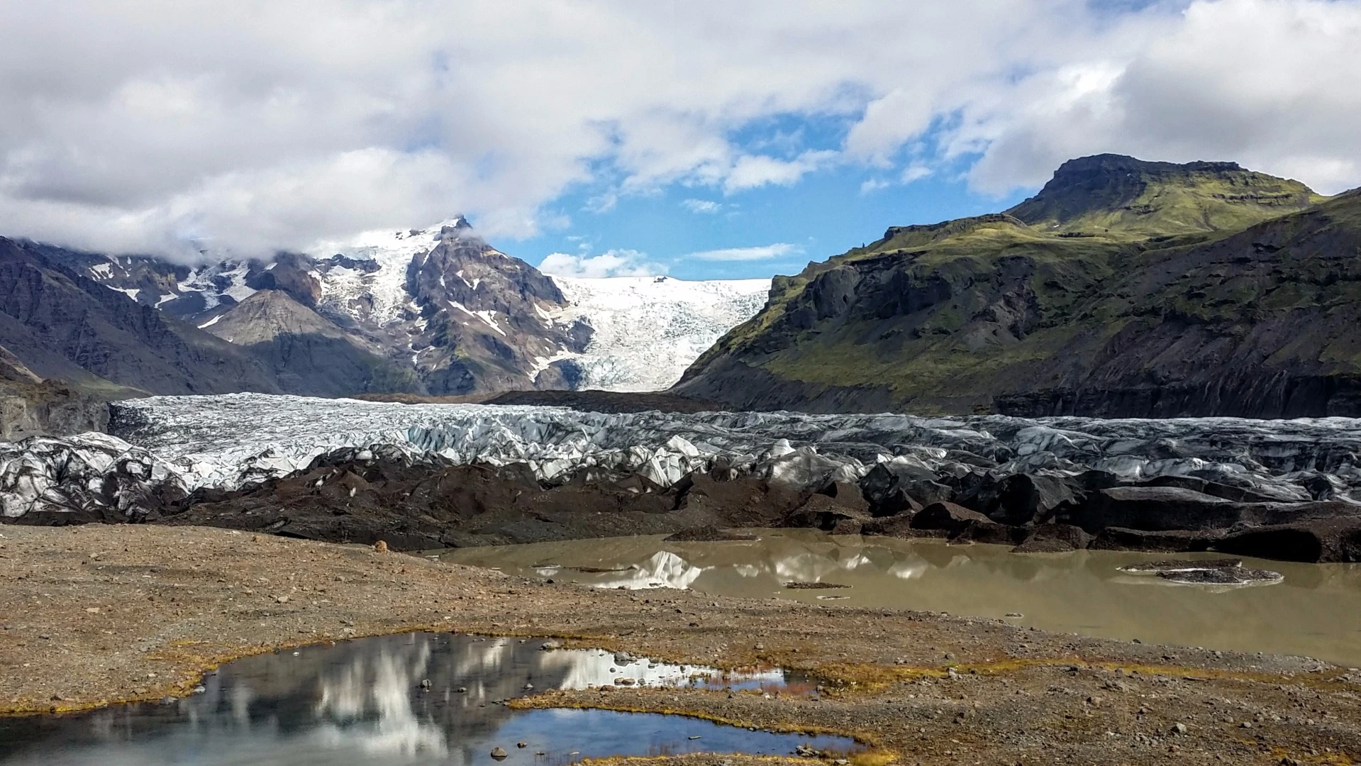
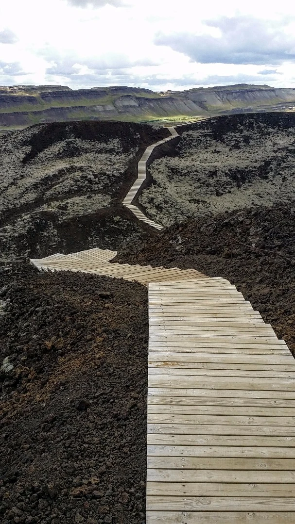
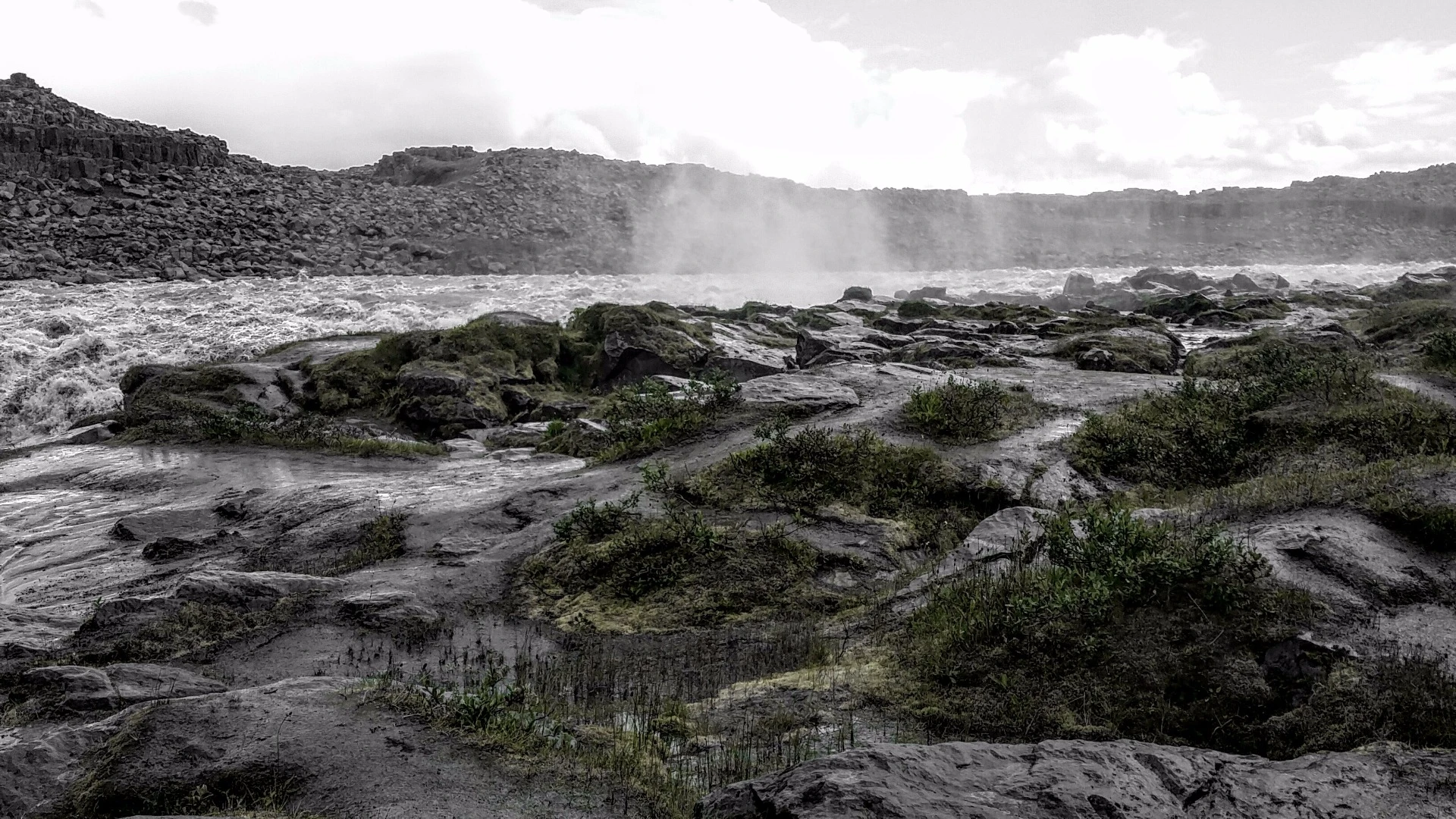
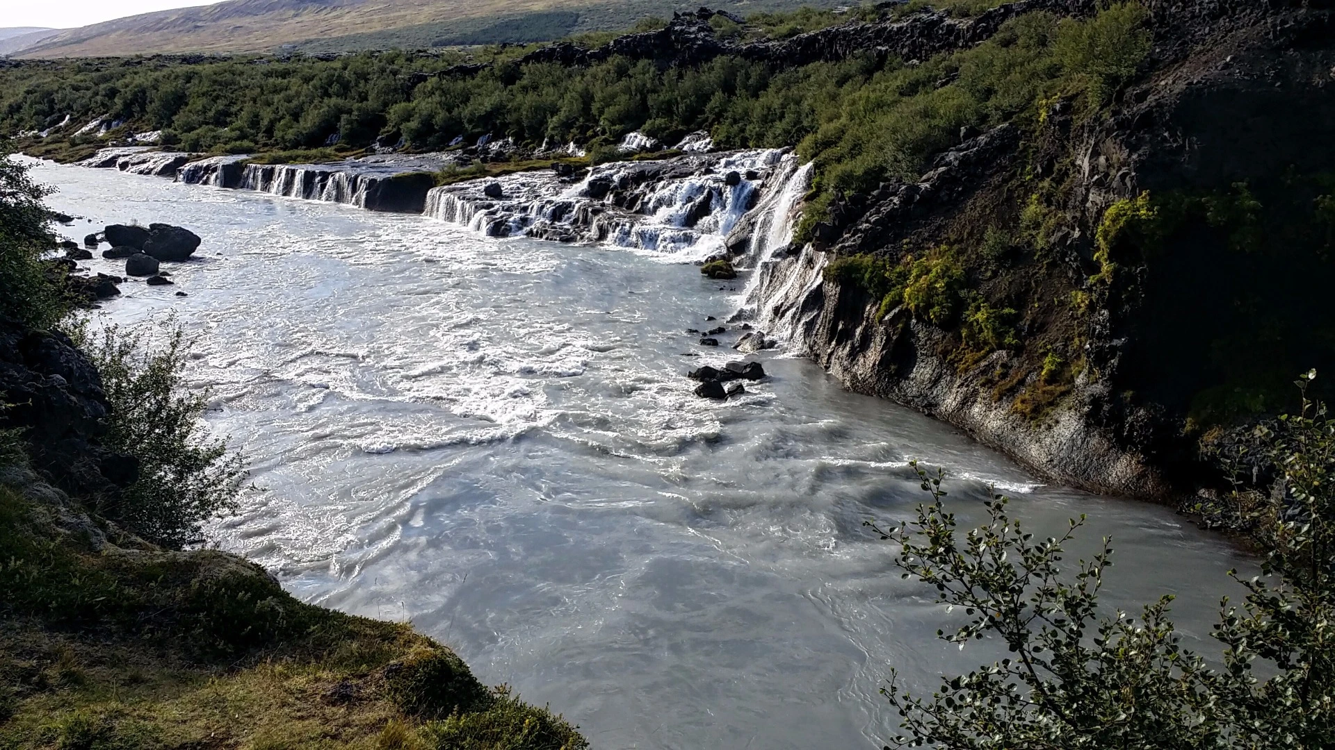
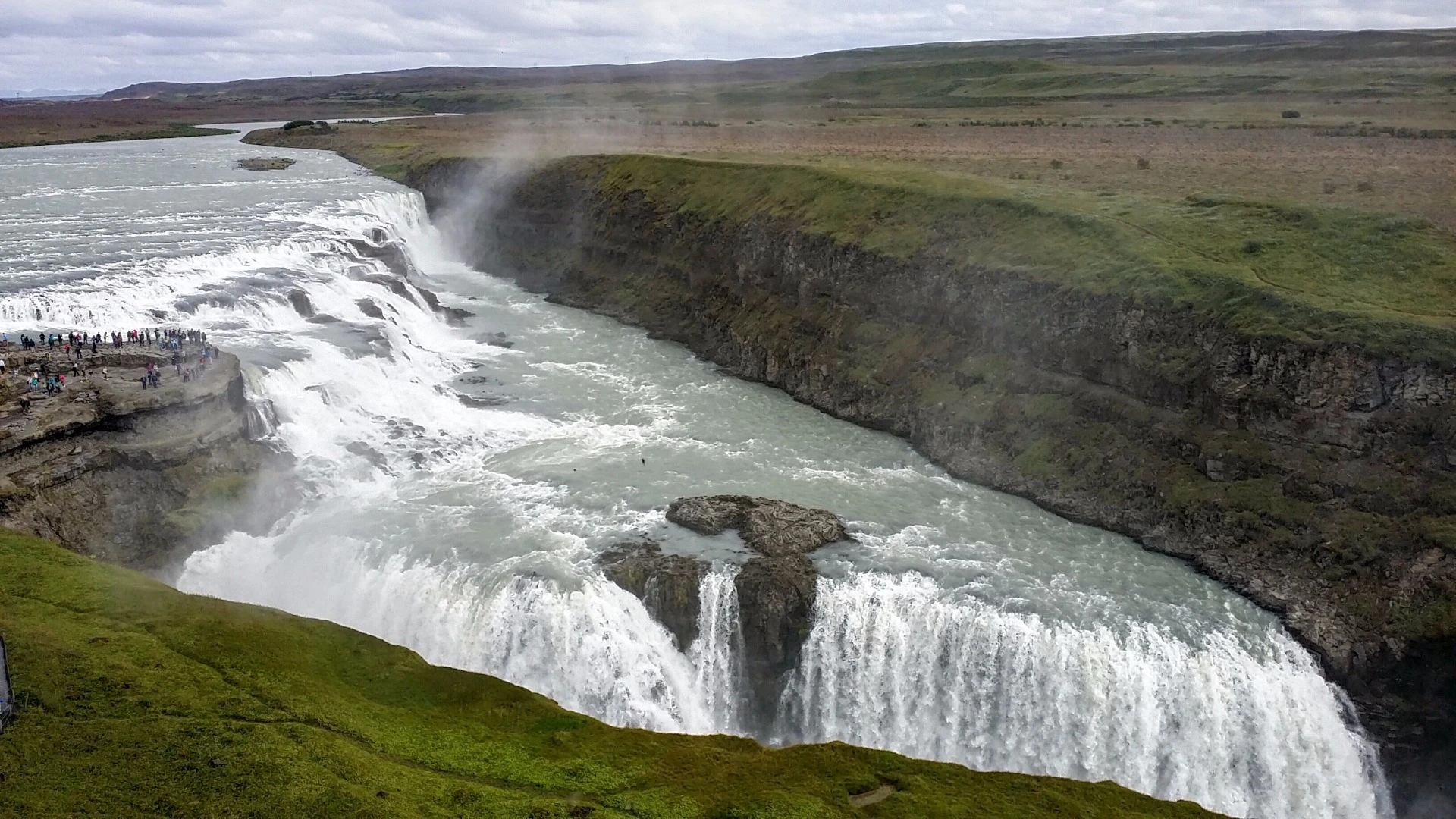
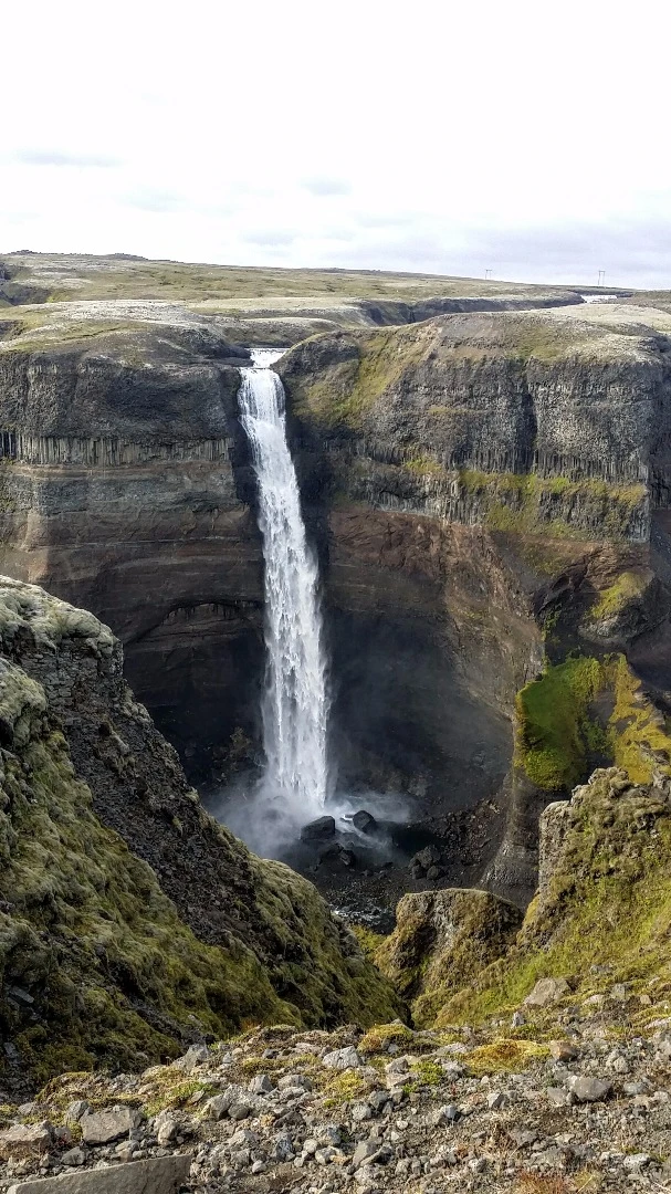
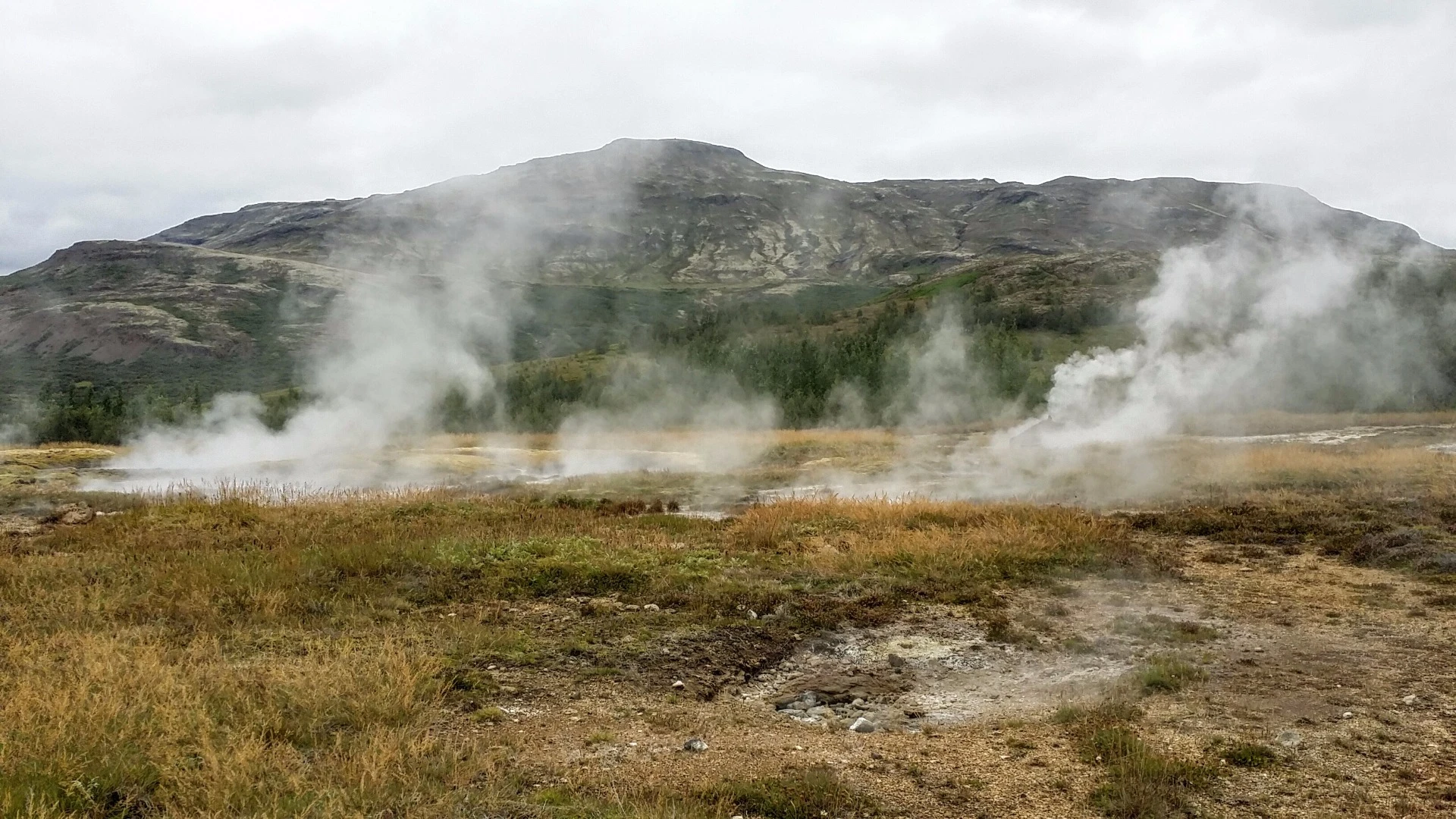
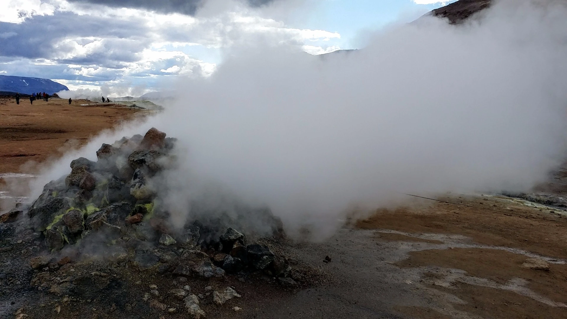
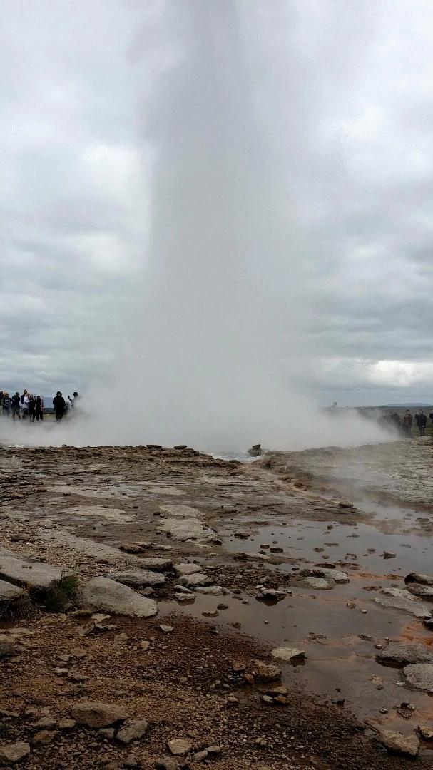
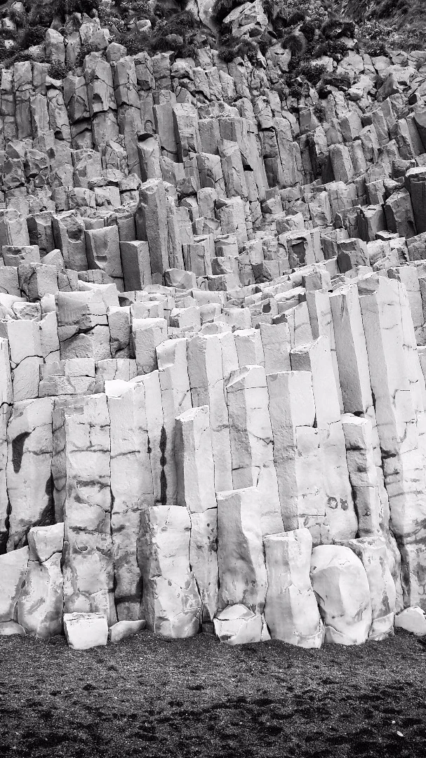
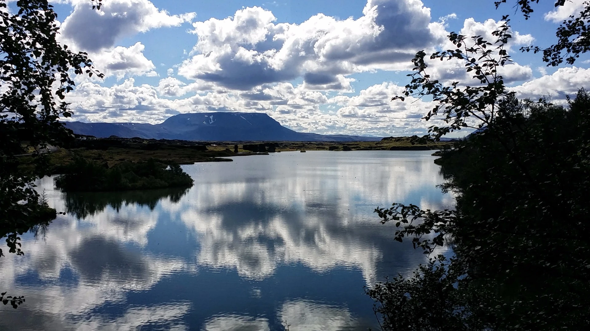
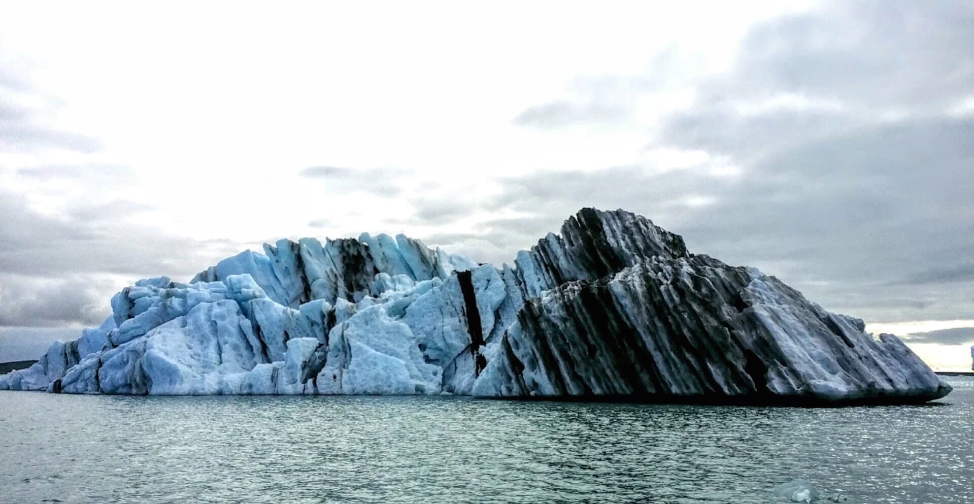
Driving along Route 1, the "Ring Road" that encircles the island country of Iceland, it's easy to feel as though you've traveled back in time and are witnessing the Earth as it was when it was just getting started. In many ways that's actually the case and New Atlas checked out some of the science behind the sites.

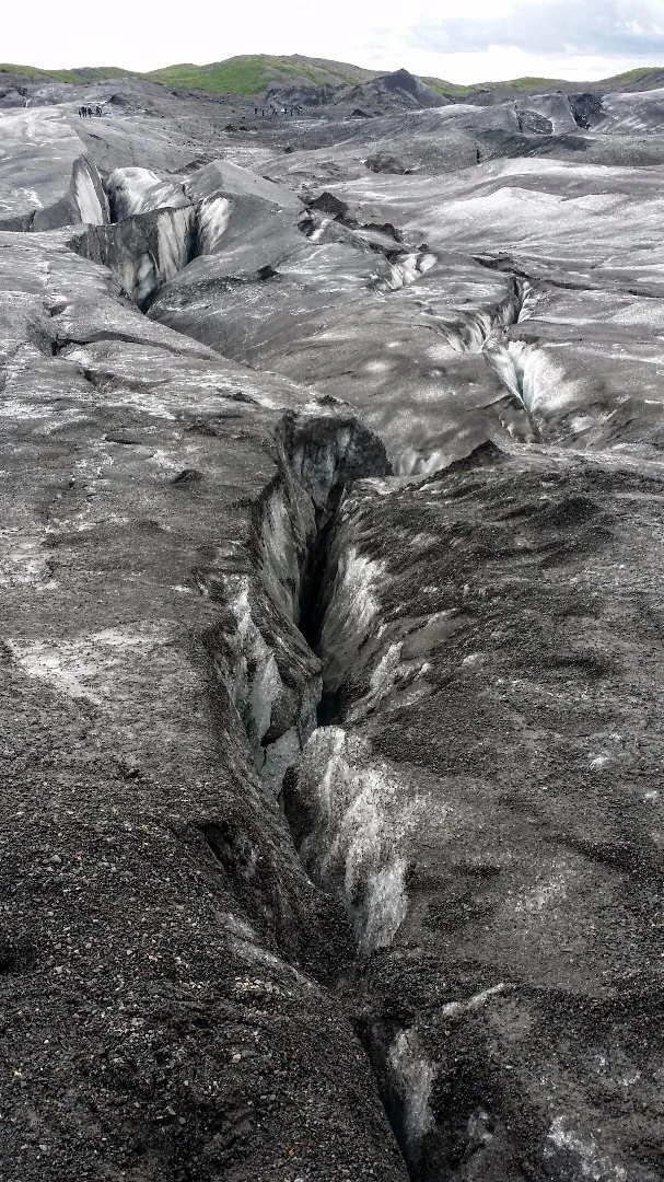
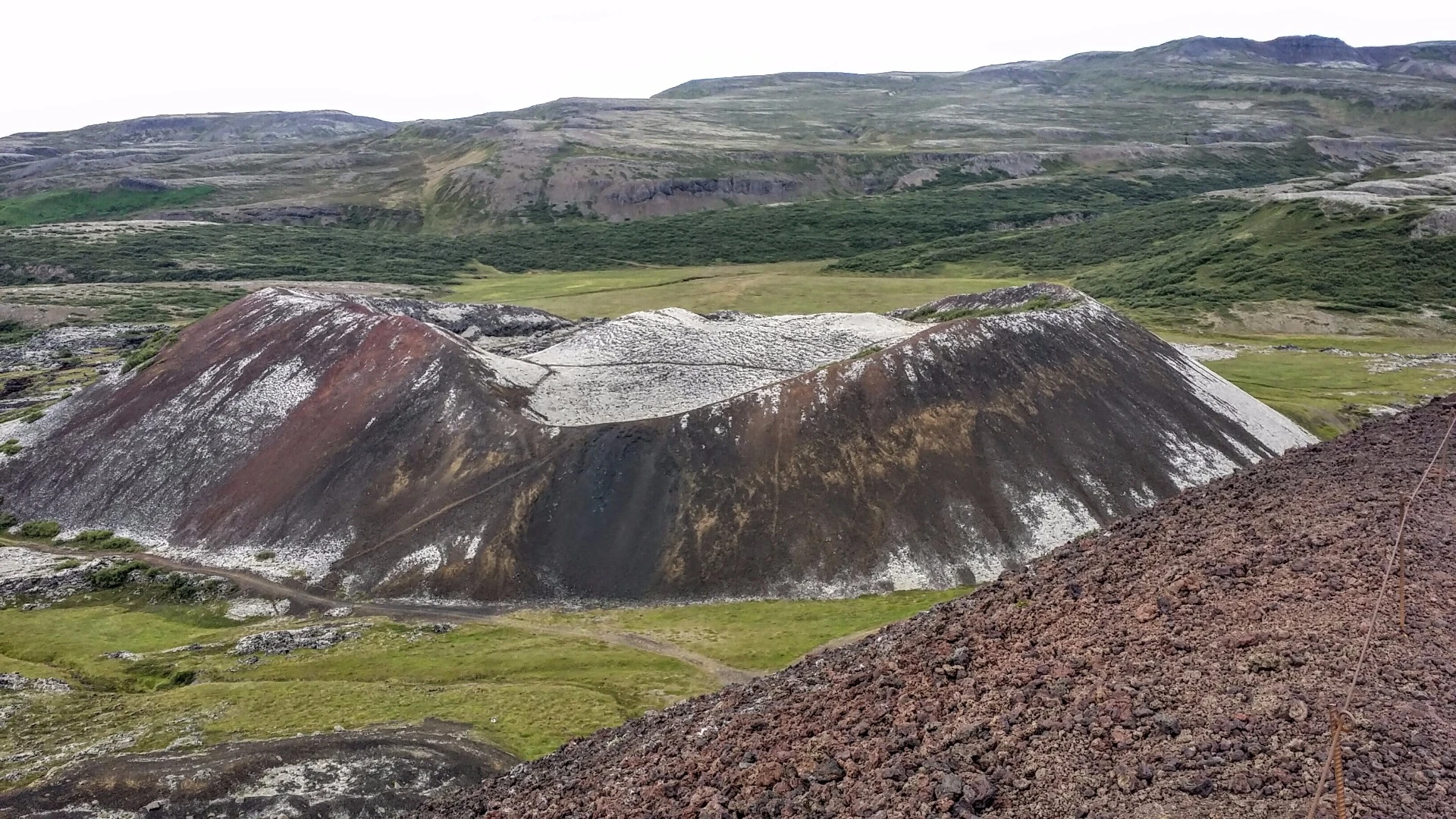
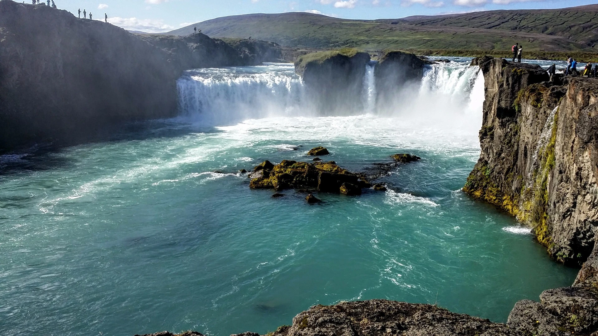
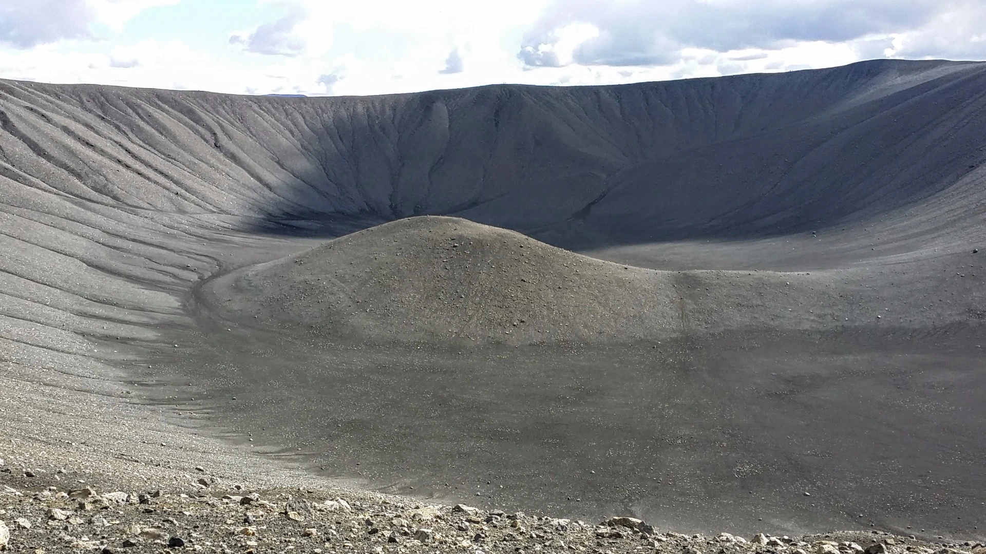
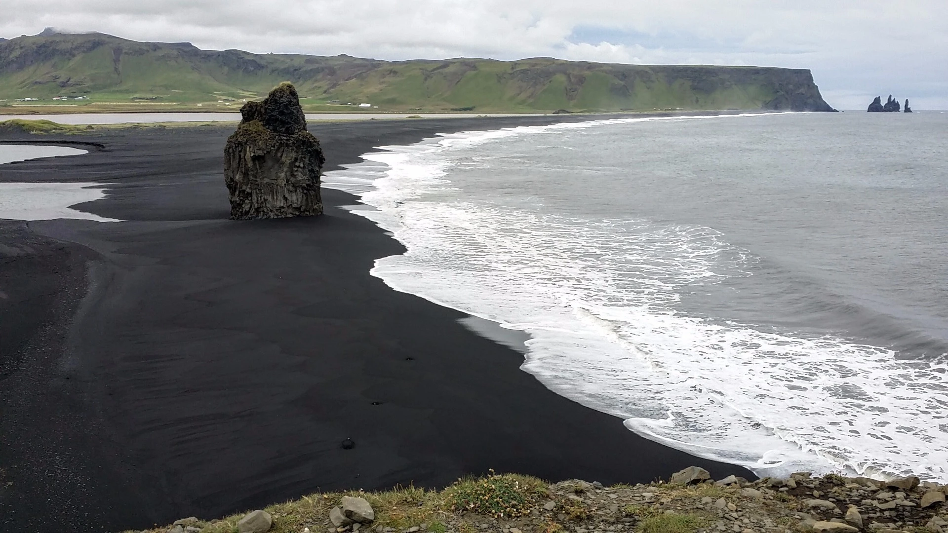
Iceland sits atop a hot spot – an area where molten rock spews from the Earth's mantle. As if that wasn't primeval drama enough, the country also straddles the Mid-Atlantic Ridge tectonic plate boundary, the spot on our planet where the North American and Eurasian plates are pulling away from each other. On top of all that – literally – sits a collection of glaciers that grind and sharpen the landscape and feed a collection of mighty waterfalls that plummet Earthward and carve their way through the mostly treeless volcanic landscape.

New Atlas recently took a tour of "Island," as the locals know it, and we were not only blown away by the beauty of the place but by some of the science behind its good looks as well.

The color of an iceberg can tell you a lot. In this berg, the stripes of black represent volcanic eruptions that spewed ash on top of ice over time. The blueish tint to the ice shows that the iceberg flipped over recently. That's because when the ice first calves from the glacier, it is compacted so tightly that light coming through it takes on a blue hue. After the iceberg flips over, as they do from getting top heavy, the ice eventually turns white as the sun creates tiny cracks in its structure.

This is a story best told through the images, so click through the gallery to see and read more about what we discovered in this land of ice and fire.

View gallery - 23 images
1 comment
1 comment
Bob Stuart
When the Vikings arrived, Iceland was mostly forest, but traditional Scandinavian management wasn't what was needed to preserve it in a marginal environment.