Space

Landsat's first LDCM images show Rocky Mountains in stunning detail

Landsat's first LDCM images show Rocky Mountains in stunning detail
The newest Landsat satellite has transmitted its first images back home (Image: NASA)
View 5 Images
The newest Landsat satellite has transmitted its first images back home (Image: NASA)
1/5
The newest Landsat satellite has transmitted its first images back home (Image: NASA)
A natural color image from the taken by the OLI sensor (Image: NASA)
2/5
A natural color image from the taken by the OLI sensor (Image: NASA)
The team's scientists can assign colors to the different wavelength to bring out important surface detail (Image: NASA)
3/5
The team's scientists can assign colors to the different wavelength to bring out important surface detail (Image: NASA)
The team can create composite images from the different wavelengths (Image: NASA)
4/5
The team can create composite images from the different wavelengths (Image: NASA)
A TIRS image from the LDCM (Image: NASA)
5/5
A TIRS image from the LDCM (Image: NASA)
View gallery - 5 images

We haven't heard anything from NASA's Landsat Data Continuity Mission (LDCM) spacecraft since its launch in February, but the satellite is now ready to start sending its first images back home. The first batch of photos are part of a three-month testing period, and show the meeting of the Great Plains with the Front Ranges of the Rocky Mountains in Wyoming and Colorado. Viewed from space, it's already a pretty spectacular scene, but the images from the LDCM managed to enhance it even further.

The Landsat program is a 40-year long project which works to study the dynamic and ongoing changes to our planet. The program's newest satellite, which is set to be given the title of Landsat 8 when it becomes fully operational, carries a range of new sensors that allow for more detailed images than ever before.

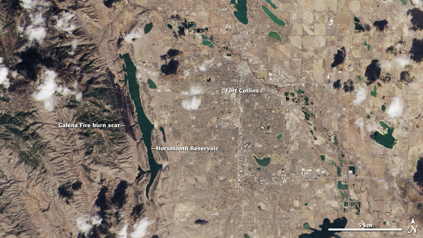
The natural color images are handled by the the LDCM's Operational Land Imager (OLI) instrument. These images, the first example of which can be seen below, show the landscape in the same colors our eyes would see.

A natural color image from the taken by the OLI sensor (Image: NASA)

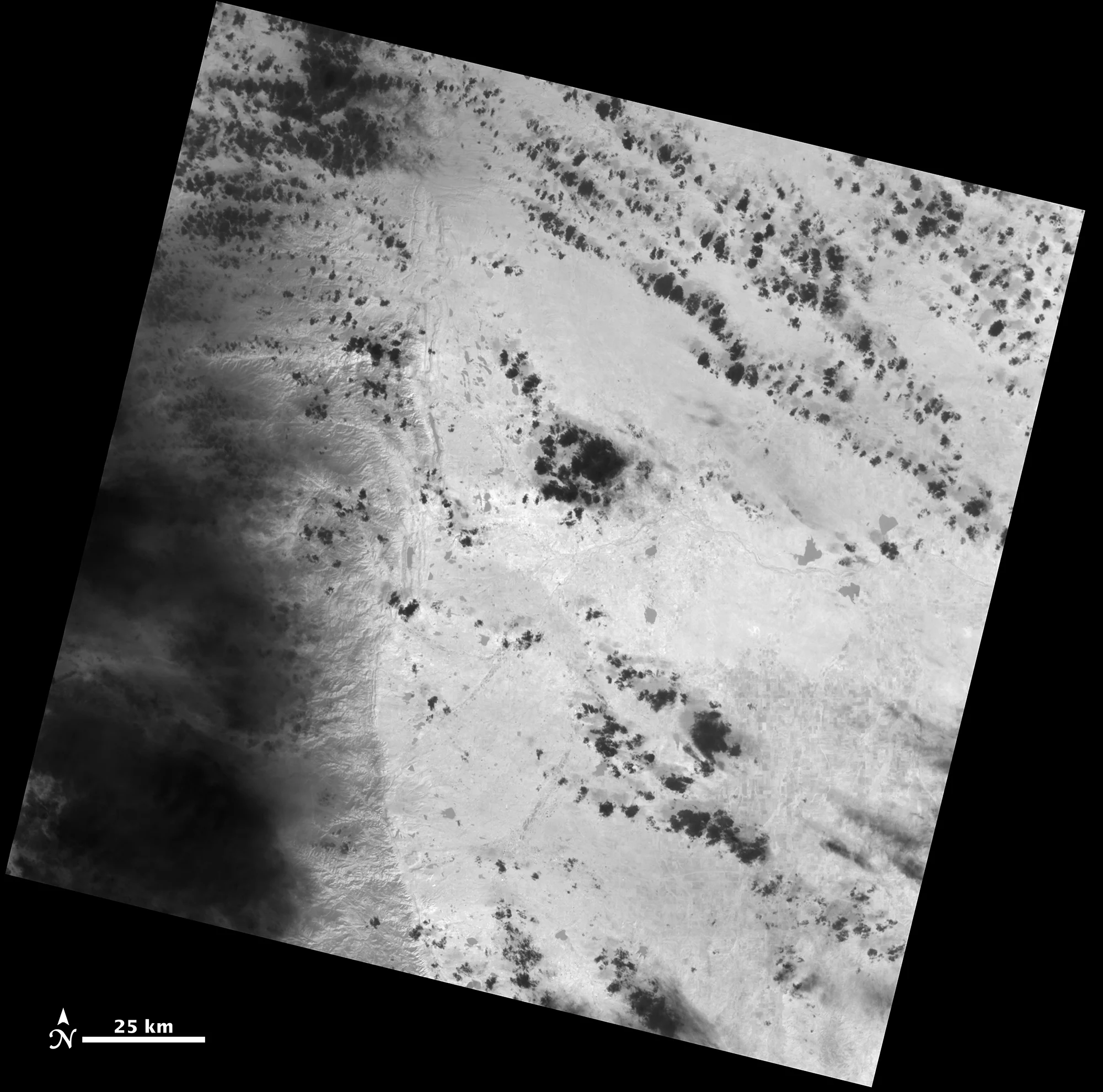
The OLI instrument accounts for eight of the 11 bands of the electromagnetic spectrum that are visible to the new Landsat sensors. Another instrument, known as the Thermal Infrared Sensor (TIRS), detects light reflected from the surface in two longer wavelengths called thermal infrared.

These images act as a measurement of surface temperature, with the warmer areas appearing brighter and the cooler areas darker. The TIRS measurements are one of the most important functions of the Landsat mission, with the resulting data being used for water management analysis.

A TIRS image from the LDCM (Image: NASA)

As both the OLI and TIRS images are collected at the same time, the team is able to combine the data to create composites image, as shown below. This method allows for the production of extremely detailed and informative images that reveal features on the landscape that the human eye would usually miss.

The team can create composite images from the different wavelengths (Image: NASA)

The team's analysts are able to assign artificial colors to data from different spectral bands, making it easier to distinguish key surface features. A closer look at the OLI's natural color image of the Fort Collins area will reveal a dark stripe west of the Horsetooth Reservoir. This mark, which is a scar left by the Galena wildfire, appears red in the false color image created using OLI bands 3 (green), 5 (near infrared) and 7 (short wave infrared 2). The bands were assigned specific colors (blue, green and red), in order to make the feature more easily visible.

This data will actually be used by Burned Area Emergency Response teams to aid them in the planning of wildfire recovery measures, making it a great example of the importance of the Landsat program.

These early images were taken using the LDCM's pre-launch settings, with the instruments likely requiring some adjustment now that the satellite is in orbit. The team is already encouraged by the early results, with TIRS instrument scientist Dennis Reuter responding with “Wow! This is beautiful!” when shown the images.

Source: NASA

View gallery - 5 images
9 comments
9 comments
Slowburn
The problem is that the new satellite is generating data that is incomparable with the old landsat data so you can't honestly use it to measure change. Just because the new satellite can see something that the old one didn't does not mean it wasn't there before.
Joel Detrow
Even if what you say is true, Slowburn, future satellite data WILL be comparable to THIS Landsat's data. This is a good thing.
Slowburn
re; Joel Detrow
The Landsat program is a 40-year long project which works to study the dynamic and ongoing changes to our planet. Throwing out the first 40-years worth of data is not a good way to do the mission.
The Skud
Slowburn, you are going ahead with the wrong reasons. Every little feature in the 'new' landscape may have been there before, and that will be true of most of them, BUT, at least you can see them more clearly, in natural - not 'adjusted' colours - for comparison to a picture you already have. The previous pictures will still be used for reference and comparison ... did people immediately toss out all B/W images when colour was invented?
Slowburn
re; The Skud
The difference between color and grey scale (B/W) imaging is trivial. Differences in resolution is not. Imagine studying a city from 30year old overhead photos with a 3m resolution compared to using new overhead photos with .25m resolution. With the first you can find the streets, with the second you can find manholes. Does it mean that they built sewers and utility tunnels in the last thirty years or were the manholes there when the first photos were taken. People with an axe to grind will make claims.
Mattias Thuresson
Photo #1 is Boulder, Colorado?
Michael Patrick
It is called the Landsat "DATA CONTINUITY" mission for a reason. The bands of the new sensors were selected because they were compatible with previous Landsat missions, plus adding some new bands for specific customers and uses. RTFM: http://ldcm.gsfc.nasa.gov/spacecraft_instruments/oli_reqs.html
As to resolution, there a re many processing methods of aligning both spectral and spatial imagery. Old low res can be pan-sharpened ( http://en.wikipedia.org/wiki/Pansharpened_image ) with co-temporal ( at about the same time ) imagery from other sources, like aerial photography. Or the higher resolution set could be down sampled in various ways to match the older data. Non-aligned spectral bands between image sets can calibrated using common features in both sets and interpolated, or against another sensor platform. One can take the older imagery and use multispectral analysis linear unmixing interpolation and re-assignment to get sub-pixel data.
For that matter, no two images are ever exactly the same - atmospheric effects (clouds, dust, pollution, etc.), time of year, orbital precession, topographic effects, seasons ( vegetation leaf cover, snow, etc. ), instrument calibration - all these change over time. Some in span of seconds, some over decades.
Making comparisons between the old and the new Landsat images is actually almost trivial - especially if one is making the comparision on post processed results like NDVI ( http://en.wikipedia.org/wiki/NDVI ).
Slowburn
re; Michael Patrick
Having a computer make up data that is consistent with the original does not mean that it is correct.
mike65401
SLOWBURN - As a retired USGS cartographer I think that sensors with increased resolution and increased bandwidth are always better. By your logic, they should have never started landsat in the first place because it had better bandwidth than the existing aerial photography.