
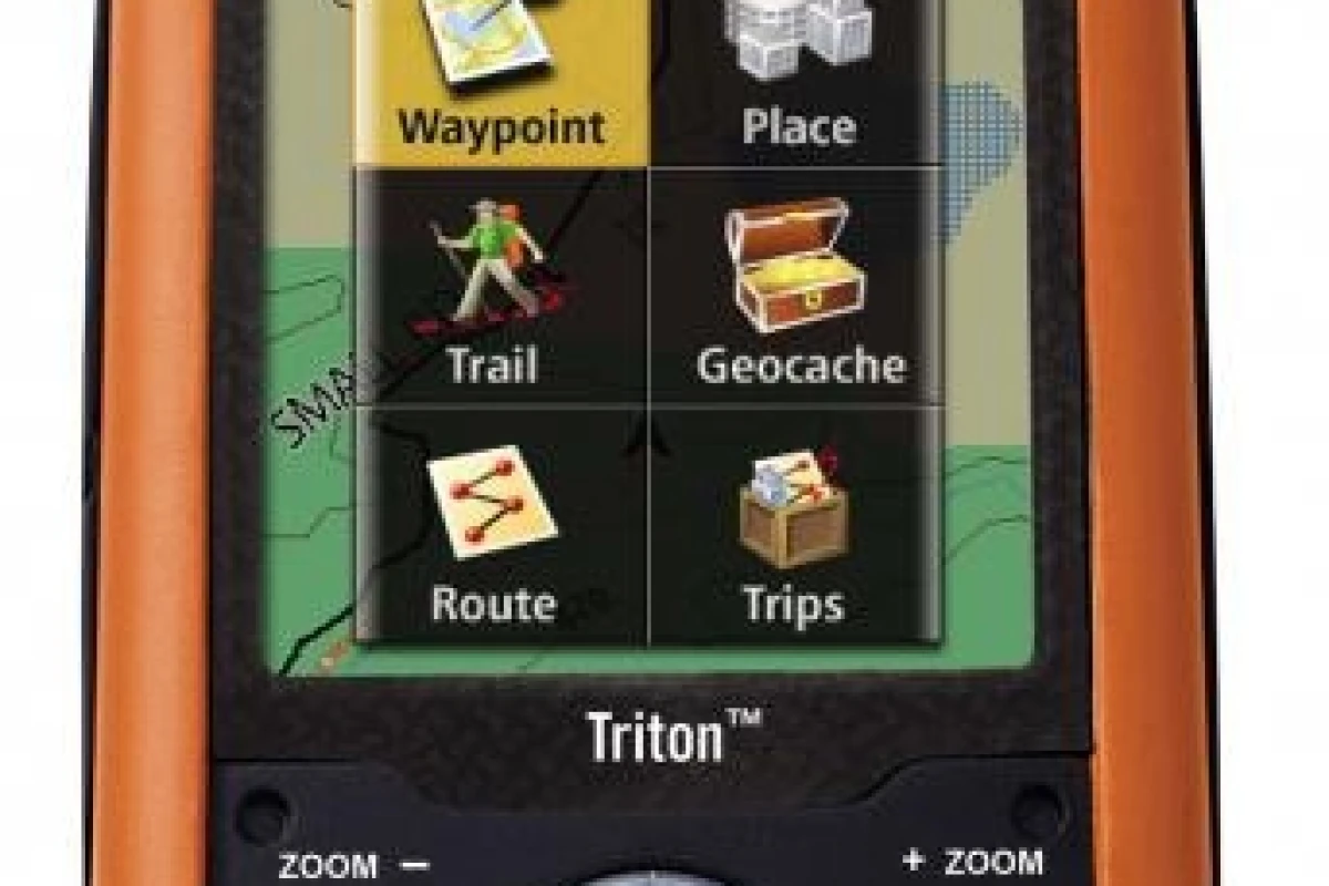
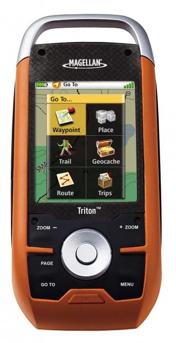
August 9, 2007 While we think Magellan’s hopes of making a GPS the central convergent device are folly in the longer run, the company’s new Triton series of portable handheld GPS receivers feature an interesting and useful range of functionality - ready to use out of the box with built-in base maps, the ruggedised Triton 2000 features a newly redesigned user interface with color, 2.7-inch QVGA touch screen that enables the easy selection of routes, waypoints and other features. It also includes a built-in 2MP camera, SD card slot, electronic compass and barometer, speaker/microphone and flashlight.
The Triton series of six new units is the first line of rugged, handheld navigation devices designed with a new user interface flow and screen graphics making Triton easier to use and more accessible to a greater population of outdoor enthusiasts.
The Triton series is significantly easier to use than previous versions of any outdoor GPS device, creating new opportunities to reach people who enjoy outdoor activities – an estimated market of 120 million people in the U.S. alone – but may not have used GPS in the past because of complexity, restricted features, and the limitations of available detailed outdoor maps. In 2008, more than 6 million outdoor GPS units are expected to be sold worldwide.
The full-featured Triton units offer full-color, touch-screen controls and the ability to record and attach audio to waypoint files. Other features unique to Triton include a built-in 2megapixel camera, digital compass, barometer and built-in LED flashlight. All of these features are elegantly integrated and designed to create an overall experience not found in any handheld GPS today.
IPX-7 rated and water submersible, the Triton series delivers ruggedness required by even the most demanding outdoor enthusiast.
As a result of an alliance between Magellan and National Geographic, the Triton series is the first outdoor handheld to offer users access to downloadable National Geographic topographic maps. This alliance with Magellan marks the first time that National Geographic maps will be made available on a handheld GPS device.
Additionally, Triton is the first Magellan handheld GPS to feature the new, free map and content management application, VantagePoint™, which enables users to easily upgrade and share information to and from their Magellan units. VantagePoint will allow Triton users to download additional maps onto their devices, as well as upload stored treks, waypoints and other recorded media.
National Geographic Maps
Magellan Triton is the first device to offer full, onscreen compatibility, usage and display of National Geographic’s maps. National Geographic offers its 28 titles of TOPO! outdoor recreation mapping software titles (covering all 50 states), which include five layers of maps – from National Geographic Atlas maps to the most detailed U.S. Geological Survey (USGS) topographic maps.
In addition, Triton is the first handheld GPS that allows adventurers to download maps and waypoints from TOPO! and from National Geographic’s new Weekend Explorer 3D, which includes 21 titles for major urban centers and surrounding recreational areas.
Users can now have Magellan’s topographic maps and National Geographic maps layered on one device for a complete best-in-class mapping experience.
VantagePoint
VantagePoint from Magellan is the first desktop application that lets people manage and expand their GPS experience. This powerful, free tool lets users easily upgrade and share information to and from their Magellan units. VantagePoint will enable the Triton user to download additional maps onto their Triton's, as well as upload stored tracks, waypoints and other media information.
“The new Triton series of handheld receivers was designed to bring handheld GPS to a new and expanded audience with the kind of experience our team of outdoor enthusiasts have dreamed of – a rugged GPS navigation device with a full-color touch screen, friendly user interface, built-in camera and media recorder to capture visited locations, and for the first time ever, access to National Geographic maps on a handheld device,” said Stig Pedersen, senior director of marketing for Magellan. “The Triton is the ideal backpack or tackle box companion for hikers and backpackers, hunters and fishermen, boaters, and geocachers. With access to free, downloadable VantagePoint software to sync together additional maps and multimedia applications, the Triton devices are the easiest and most versatile outdoor navigation solutions available.”
The penetration of GPS devices in the core outdoor segments of backpacking, hiking and hunting remains at relatively low level of about 5 percent. With its improved ease-of-use, increased feature set and multi-media capabilities, Magellan Triton is aimed at increasing market penetration.
Magellan will be donating a portion of the proceeds from Triton sales through December 31, 2007, to the National Park Foundation to assist in its efforts to help sustain the conservation, preservation and enjoyment of America’s national treasures. Additionally, Magellan will be donating 500 new Triton units to the National Park Foundation to use as needed to support its programs.
Triton 2000
The Triton 2000, available in North America in September and in Europe in October, was designed by Magellan’s product development team of outdoor enthusiasts to be the ultimate handheld device for any adventurer, from hiker to outdoorsman. Ready to use out of the box with built-in base maps, the Triton 2000 features a newly redesigned user interface with color, 2.7-inch QVGA touch screen that enables the easy selection of routes, waypoints and other features. It also includes a built-in 2MP camera, SD card slot, electronic compass and barometer, speaker/microphone and flashlight.
Additionally, the Triton 2000 features uploadable maps using VantagePoint software, pointer and compass screen, and is waterproof to IPX-7 standards. The unit will retail for US$499.
Triton 1500
Similar to the 2000, the Triton 1500 is features a 2.7-inch QVGA color touch screen featuring built-in base maps, uploadable maps using VantagePoint software, SD card slot, speaker and microphone, flashlight, and is waterproof to IPX-7 standards. Ideal for sportsmen, the unit will retail for US$399.
Triton 500
The more compact-sized Triton 500 features a 2.2-inch QVGA color screen, SD card slot to enable users to install and save maps and data onto a flash card, uploadable maps using VantagePoint software, built-in base maps, an electronic compass and barometer, and is waterproof to IPX-7 standards. The backcountry backpacker will appreciate the Triton 500, which will retail for US$249.
Triton 400
Similar to the 500, the Triton 400 includes 2.2-inch QVGA color screen, SD card slot, built-in base maps, pointer and compass screen, and is waterproof to IPX-7 standards. The Triton 400 also features uploadable maps using VantagePoint software. The unit will retail for US$199.
Triton 300
In addition to a 2.2-inch QVGA color screen, built-in base maps, waterproof to IPX-7 design, pointer and compass screen, the Triton 300 features uploadable maps using VantagePoint software and 10 MB of memory for map storage. The unit will retail for US$149.
Triton 200
The Triton 200 is the base model in the series, and includes a 2.2-inch QVGA color screen, built-in base maps, waterproof to IPX-7 design, pointer and compass screen, and runs on two AA batteries. An ideal companion for the weekend hiker, the unit will retail for US$129.
The Triton series is expected to ship to all major U.S. retailers in September and in Europe in October. Available accessories for Triton products will include bicycle and swivel mounts, vehicle mounts, and carrying cases.


