The use of "ocean gliders" for conducting research in oceanic conditions not ideal for regular methods has been catching on in the scientific community. Examples of this have been seen in the detection of endangered whales in the North Atlantic and a study of the Atlantic sturgeon. Researchers have now turned their robotic ocean helpers towards Antarctica, to study the rapidly-melting ice sheets on the coast of the western part of that polar land mass.
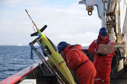
The bullet-shaped ocean gliders at the heart of the study are fascinating in that they have no propeller and are instead given motion by a battery-powered pump that changes their buoyancy. Fluid from the pump is moved into a compartment inside the glider, making it less buoyant so it can sink. When this fluid is then pumped into an external bladder, it rises to the surface. Wings on the 6-foot (1.8-m)-long device translate this lift into motion.
Caltech researchers, using the gliders, set out to understand how it is that warm water, considered the main factor causing the Antarctic ice to melt, is ending up near the coast of the otherwise very cold continent. By having the energy-efficient gliders remain at sea for months at a time to do extended data collection, they found that the warm water was being carried along by so-called ocean eddies, which are similar to storms in the atmosphere.
"Eddies are instabilities that are caused by ocean currents, and we often compare their effect on the ocean to putting a spoon in your coffee," said researcher Andrew Thompson. "If you pour milk in your coffee and then you stir it with a spoon, the spoon enhances your ability to mix the milk into the coffee and that is what these eddies do. They are very good at mixing heat and other properties."

These eddies, given their variable conditions and remote locations, were better suited to being studied by the gliders versus large ships, particularly over an extended period of time. The gliders were also more useful than satellite data collection, owing to the fact the warm water is not on the surface, and thus something the satellites could not detect.
Robotic gliders at work
Researchers dropped the gliders into the waters in January 2012. The gliders then spent the next two months moving up and down through the eddies off the Antarctic coast, collecting temperature and salinity data at different locations and depths, and occasionally surfacing to "call home" the collection information.The gliders observed that temperature and salinity, working together, create a situation whereby the warmest water is not on top, but actually sandwiched in the middle layers of the water.
"You can't just take measurements at the surface," said Thompson. "You actually need to be taking a look at that very warm temperature layer, which happens to sit in the middle of the water column. That's the layer that is actually moving toward the ice shelf."
The Caltech team next plans to add meteorological data to what’s collected from the gliders. They will also use the gliders in conjunction with a surface Wave Glider robot to study how air and water play together in a spot of ocean between the southern tip of South America and Antarctica, called the Drake Passage.
You can watch a brief video of how the gliders work below.