Environment

5,200 holes carved into a Peruvian mountain left by an ancient economy

5,200 holes carved into a Peruvian mountain left by an ancient economy
The stretch of thousands of holes earned the site its name, Mont Sierpe ("serpent mountain")
View 5 Images
The stretch of thousands of holes earned the site its name, Mont Sierpe ("serpent mountain")
1/5
The stretch of thousands of holes earned the site its name, Mont Sierpe ("serpent mountain")
Drone imagery and sediment samples have offered new insight into the Band of Holes' origins
2/5
Drone imagery and sediment samples have offered new insight into the Band of Holes' origins
An aerial photograph of Monte Sierpe taken by Robert Shippee and published in National Geographic in 1933
3/5
An aerial photograph of Monte Sierpe taken by Robert Shippee and published in National Geographic in 1933
Aerial photographs of the Band of Holes and its surrounding environment (a-c) and ground-level photograph of the holes (d)
4/5
Aerial photographs of the Band of Holes and its surrounding environment (a-c) and ground-level photograph of the holes (d)
A digital elevation model overlaid on an orthomosaic of Monte Sierpe reveals layout patterns within sections a, b and c. Black numbers indicate counts of holes east to west; black arrow in b marks space between sections
5/5
A digital elevation model overlaid on an orthomosaic of Monte Sierpe reveals layout patterns within sections a, b and c. Black numbers indicate counts of holes east to west; black arrow in b marks space between sections
View gallery - 5 images

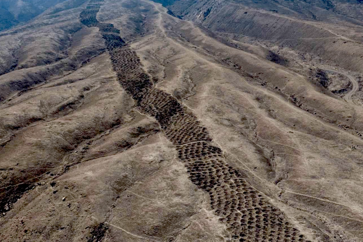
For nearly a century, a strange band of thousands of holes carved into a Peruvian hillside has defied explanation. Stretching for nearly a mile (1.5 km) along the edge of the Pisco Valley, Monte Sierpe – "serpent mountain" appears to be a deliberate, repetitive and almost mathematical feature – but its real purpose has so far eluded scientists.

Now, researchers from the University of Sydney believe they have cracked the code of the so-called "Band of Holes," with a far more human explanation than previously thought. In fact, the archeologists have found new clues that point to the mysterious stretch of holed-out ground as being some kind of indigenous trade and accounting system that had been built into the landscape and primarily used during the Late Intermediate Period, which in this region spans roughly 1000-1450 CE, probably around the 14th century.

“Why would ancient peoples make over 5000 holes in the foothills of southern Peru?" said Dr Jacob Bongers, lead author and digital archeologist at the University of Sydney. "Were they gardens? Did they capture water? Did they have an agricultural function? We don’t know why they are here, but we have produced some promising new data that yield important clues and support novel theories about the site’s use.

Aerial photographs of the Band of Holes and its surrounding environment (a-c) and ground-level photograph of the holes (d)

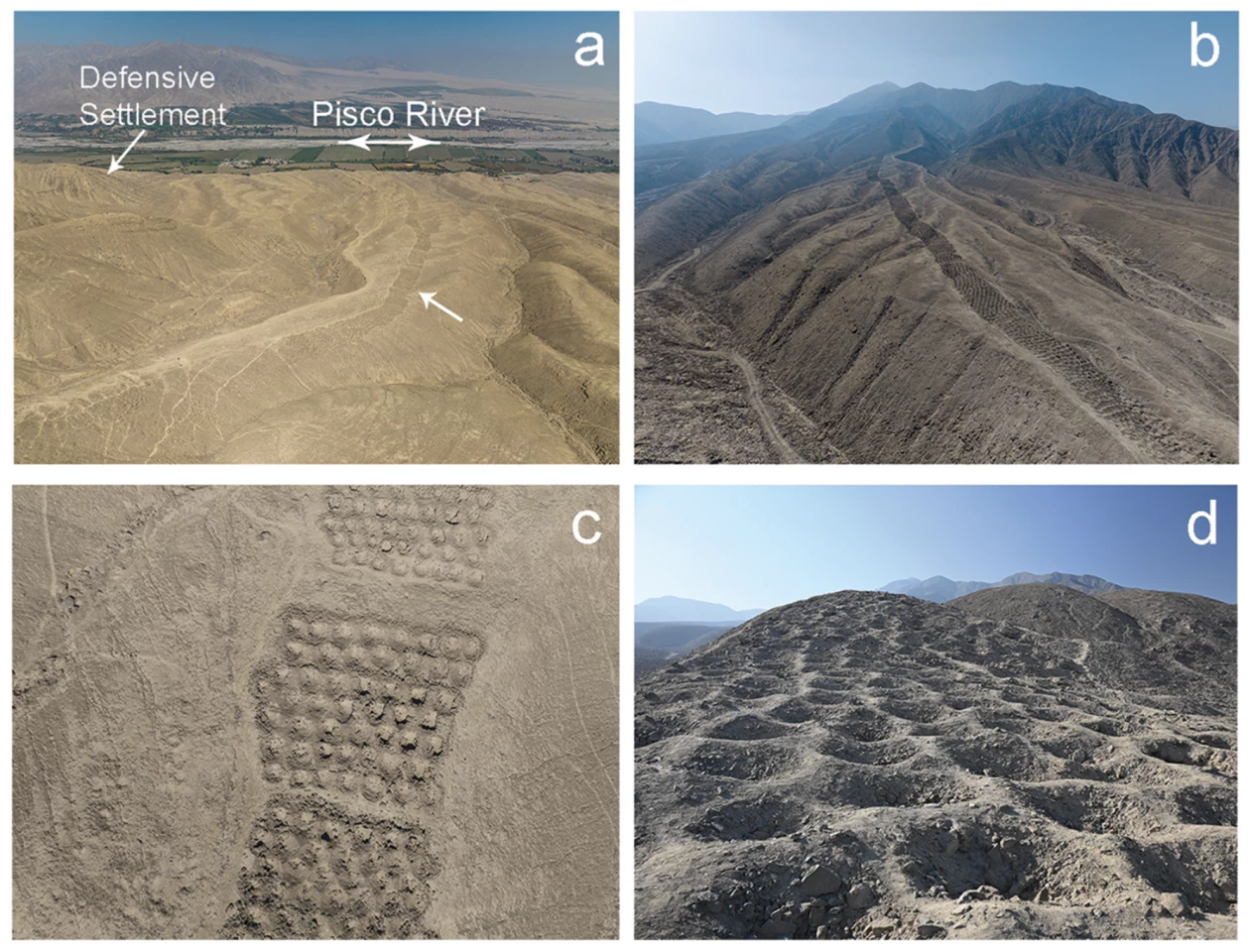
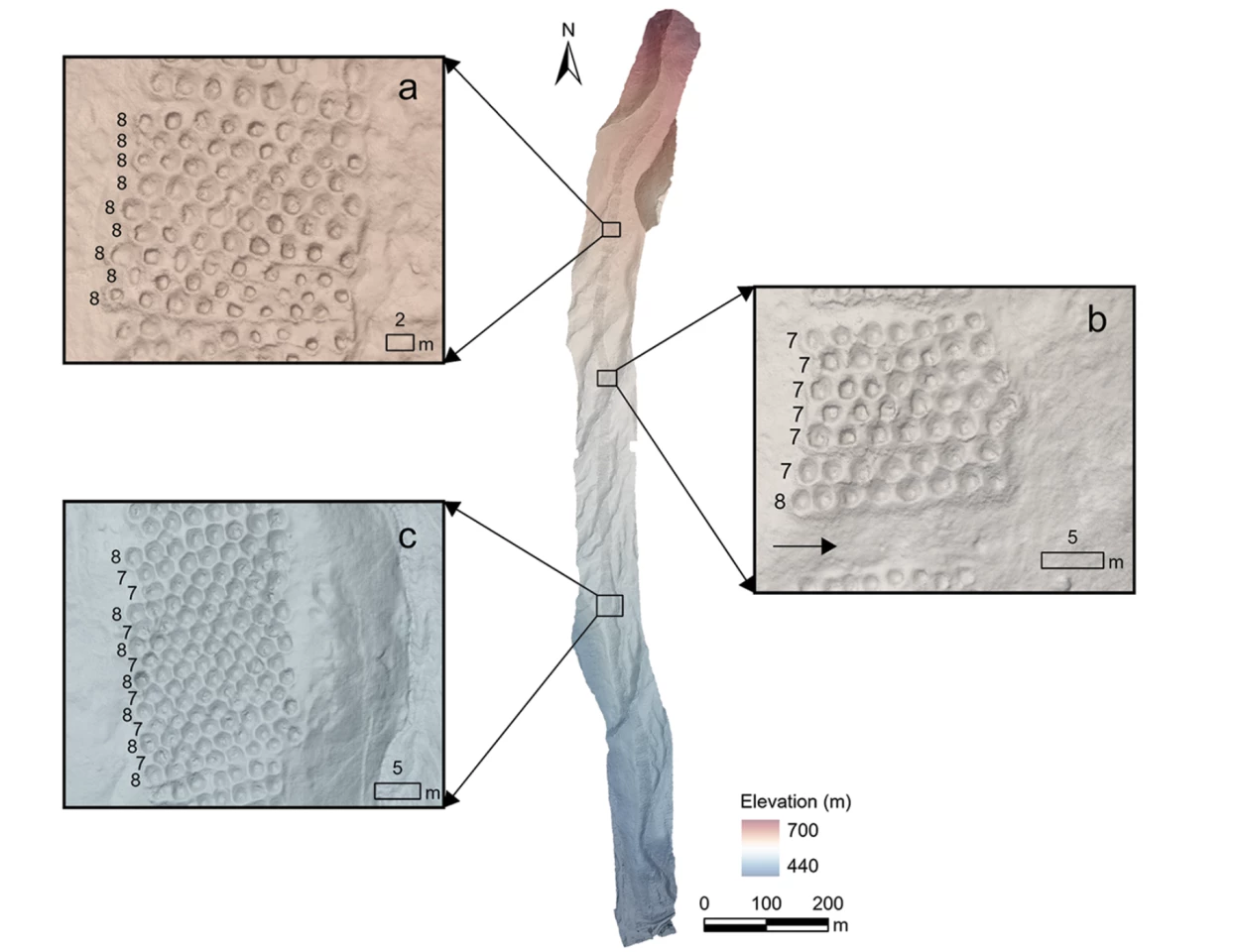
Using drones to map the site in unprecedented detail, the researchers found numerical patterns in the placement, hinting at a hidden functionality beyond aesthetics. They also discovered that Monte Sierpe is similar to the structure of at least one Inca khipu (an ancient knotted-string accounting device) that was recovered from the same valley.

“This is an extraordinary discovery that expands understandings about the origins and diversity of indigenous accounting practices within and beyond the Andes,” Bongers said.

Monte Sierpe is made up of around 5,200 shallow pits, measuring 1 to 2 m (3 to 6.5 ft) wide and 0.5 to 1 m (1.5 to 3 ft) deep, arranged into neat blocks along a narrow ridge. Each pit is roughly the size of a small storage cavity, and while the band appears continuous when sighted from a distance, closer inspection reveals that it is broken into sections, separated by gaps that allow foot traffic across the mountain. What's more, rows of holes consistently repeat the same pattern, sometimes alternating between specific numbers. Some sections contain long stretches of identical rows, while others show repeating alternations. The structure, the team argues, resembles khipus – except on at a large scale, and built into earth and stone.

A digital elevation model overlaid on an orthomosaic of Monte Sierpe reveals layout patterns within sections a, b and c. Black numbers indicate counts of holes east to west; black arrow in b marks space between sections

Hole soil analysis also found ancient pollens of maize – a key staple in the Andes – and reeds traditionally used for basket-making. In addition to this, there were traces of squash, amaranth, cotton, chili peppers and other crops that haven't been farmed on the arid land where Monte Sierpe sits. Because many of these plants produce little airborne pollen, it's unlikely they settled in the holes naturally. Instead, the researchers believe, people carried goods to the site and deposited them in the holes, likely using baskets or bundled plant fibers that were periodically replaced.

“This is very intriguing,” Bongers said. “Perhaps this was a pre-Inca marketplace, like a flea market. We know the pre-Hispanic population here was around 100,000 people. Perhaps mobile traders (seafaring merchants and llama caravans), specialists (farmers and fisherfolk), and others were coming together at the site to exchange local goods such as corn and cotton. Fundamentally, I view these holes as a type of social technology that brought people together, and later became a large-scale accounting system under the Inca Empire."

Radiocarbon dating places active use of the site in the 14th century, during the Late Intermediate Period, when the Chincha Kingdom dominated the region. Historical records describe the Chincha as skilled traders, operating networks along the coast and inland long before the arrival of the Inca. Monte Sierpe sits at a strategic crossroads between ecological zones and major pre-Hispanic roads, making it an ideal meeting point for bartering.

“There are still many more questions," Bongers says. "Why is this monument only seen here and not all over the Andes? Was Monte Sierpe a sort of ‘landscape khipu’? – but we are getting closer to understanding this mysterious site. It is very exciting.”

The researchers argue that the holes weren't storage silos in the modern sense, but markers of equivalence – a way to make quantities visible and negotiable in a society without currency. Seeing rows of filled pits would have allowed people to assess supply at a glance. Later, with the arrival of the Inca, the same infrastructure may have been repurposed. The empire relied heavily on accounting systems to manage labor, and the segmented, numerical layout of the Band of Holes would have lent itself to tracking these sorts of transactions.

An aerial photograph of Monte Sierpe taken by Robert Shippee and published in National Geographic in 1933

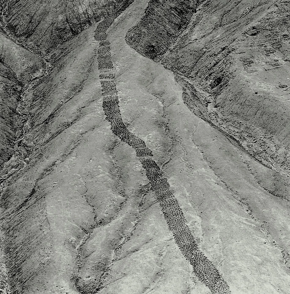
The Band of Holes garnered the attention of researchers in 1933, after aerial photos published in National Geographic sparked curiosity – and while the latest study can't confirm beyond a doubt, it provides the strongest evidence yet in Monte Sierpe's origin story.

“Hypotheses regarding Monte Sierpe’s purpose range from defense, storage, and accounting to water collection, fog capture and gardening, yet the true function of the site remains unclear,” said Dr Bongers. “This research contributes an important Andean case study on how past communities modified landscapes to bring people together and promote interaction."

The research was published in the journal Antiquity.

Source: University of Sydney

View gallery - 5 images
11 comments
11 comments
Drummer Dre
Maybe ment for multiple things, trade seems to be the highest. It makes sense that it's easy to count the amount of sections if buying a lot of certain types of food.
Troy
I spent a long time in Guyana and Venezuela mining bauxite. These holes are all over the Amazon jungle in huge sets like this. Strips of them covering large distances. I've encountered these many times in overburden removal. The local people always referred to them as portknocker holes. Portknocker is what they call these people that spend their lives wandering through the jungle digging holes for gold and diamonds. Once they find a hot spot they will dig back to back to back and follow the seam.
Loc
I would give more credit to Troy as offering a use of the holes. Talking to people that live there most likely will have a better story to explain what the holes are for. The time line is not that far back in history. I would explore that story more.
TechGazer
I wouldn't be surprised if this was the equivalent of stupid things people do to get into the Guinness Book of World Records, or even a contest or religious scam. The traces of foods, well, hardworking people need snacks and meals. Since knowing the true answer probably doesn't make much difference, just pick your favorite theory.
Troy
To touch back on what I said about the holes I can provide you with contacts there in the Amazon currently. My brothers are there on land leased and operating dredges. They may even have land with these holes on them. Nonetheless they can confirm what I'm saying. My father started the venture. He recently passed but the work remains
Emophiliac
Just a note - I live Lima. It takes about 4 hours by bus to get to Pisco and then another hour by taxi to get to this site. I have hiked it several times, once to the top, and overflown it with my drone. Each hole is constructed- dug out and lined with rock. These are not mining holes, nor used to store things. If you want to store stuff, you would put these pits along the bottom of the hill, not running a long distance up the hill. They tried to keep the lines somewhat straight, crossing gullies. I can't guess what valid use they might have had, other than religious. They seem pointless.
McDesign
"And though the holes were rather small, they had to count them all . . ."
Dan Owen
Now we know how many holes it takes to fill the Albert Hall.................
Bokon Agbi
My immediate thought was it's a site for collecting tribute.
ChromeXX
It's safe to say, since it's been proven these holes exist all over the Amazon, that they were created to catch or divert animals, to keep them from reaching their village. After finding the normal route of the animals and their crossings, the holes were possibly dug to confuse the animals and funnel them into the small foot traffic areas to be caught and killed - whether for food or to control their travel. If it would stop humans from wanting to traverse the land, animals wouldn't want to either. Also, I see "scientists" make this mistake over and over; the lay of the land now is not what it was back then, and large ravines that are there now may have been lush with greenery and completely flat. Earthquakes and landslides could have completely changed the overall landscape by now too.
Load More