Space

Mars Express captures rare "upside down" image of the Red Planet

Mars Express captures rare "upside down" image of the Red Planet
This stunning image swathe was taken by ESA’s Mars Express during camera calibration as the spacecraft flew over the north pole (Credit: ESA/DLR/FU Berlin, CC BY-SA 3.0)
This stunning image swathe was taken by ESA’s Mars Express during camera calibration as the spacecraft flew over the north pole (Credit: ESA/DLR/FU BerlinCC BY-SA 3.0)
View 65 Images
This stunning image swath was taken by ESA’s Mars Express during camera calibration as the spacecraft flew over the north pole (bottom) towards the equator (top) (Credit: ESA/DLR/FU Berlin, CC BY-SA 3.0)
1/65
This stunning image swath was taken by ESA’s Mars Express during camera calibration as the spacecraft flew over the north pole (bottom) towards the equator (top) (Credit: ESA/DLR/FU BerlinCC BY-SA 3.0)
This stunning image swathe was taken by ESA’s Mars Express during camera calibration as the spacecraft flew over the north pole (Credit: ESA/DLR/FU Berlin, CC BY-SA 3.0)
2/65
This stunning image swathe was taken by ESA’s Mars Express during camera calibration as the spacecraft flew over the north pole (Credit: ESA/DLR/FU BerlinCC BY-SA 3.0)
A base map showing the surface area covered in the Mars Express image
3/65
A base map showing the surface area covered in the Mars Express image
The topography of the Mars Express image
4/65
The topography of the Mars Express image
Perspective view of craters (Credit: ESA/DLR/FU Berlin, CC BY-SA 3.0 IGO)
5/65
Perspective view of craters (Credit: ESA/DLR/FU BerlinCC BY-SA 3.0 IGO)
Perspective view across a triple crater (Credit: ESA/DLR/FU Berlin, CC BY-SA 3.0 IGO)
6/65
Perspective view across a triple crater (Credit: ESA/DLR/FU BerlinCC BY-SA 3.0 IGO)
Perspective view across a crater in Erythraeum Chaos (Credit: ESA/DLR/FU Berlin, CC BY-SA 3.0 IGO)
7/65
Perspective view across a crater in Erythraeum Chaos (Credit: ESA/DLR/FU BerlinCC BY-SA 3.0 IGO)
Dune field in a crater, perspective view (Credit: ESA/DLR/FU Berlin, CC BY-SA 3.0 IGO)
8/65
Dune field in a crater, perspective view (Credit: ESA/DLR/FU BerlinCC BY-SA 3.0 IGO)
Perspective view of Chasma Boreale
9/65
Perspective view of Chasma Boreale
Deep crater, perspective view (Credit: ESA/DLR/FU Berlin, CC BY-SA 3.0 IGO)
10/65
Deep crater, perspective view (Credit: ESA/DLR/FU BerlinCC BY-SA 3.0 IGO)
Perspective view of Libya Montes (Credit: ESA/DLR/FU Berlin, CC BY-SA 3.0 IGO)
11/65
Perspective view of Libya Montes (Credit: ESA/DLR/FU BerlinCC BY-SA 3.0 IGO)
Perspective view of Mars north polar ice cap
12/65
Perspective view of Mars north polar ice cap
Perspective view towards Worcester crater (Credit: ESA/DLR/FU Berlin, CC BY-SA 3.0 IGO)
13/65
Perspective view towards Worcester crater (Credit: ESA/DLR/FU BerlinCC BY-SA 3.0 IGO)
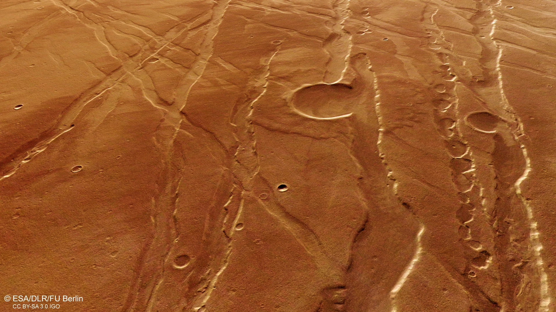
Sirenum Fossae fractures (Credit: ESA/DLR/FU Berlin, CC BY-SA 3.0 IGO)
14/65
Sirenum Fossae fractures (Credit: ESA/DLR/FU BerlinCC BY-SA 3.0 IGO)
Sirenum Fossae perspective view (Credit: ESA/DLR/FU Berlin, CC BY-SA 3.0 IGO)
15/65
Sirenum Fossae perspective view (Credit: ESA/DLR/FU BerlinCC BY-SA 3.0 IGO)
Perspective view of features in the Ascuris Planum region of Mars, including graben running in various directions, breached impact craters and pit chains (Credit: ESA/DLR/FU Berlin, CC BY-SA 3.0 IGO)
16/65
Perspective view of features in the Ascuris Planum region of Mars, including graben running in various directions, breached impact craters and pit chains (Credit: ESA/DLR/FU BerlinCC BY-SA 3.0 IGO)
Mars Express spies a nameless and ancient impact crater (Credit: ESA/DLR/FU Berlin, CC BY-SA 3.0 IGO)
17/65
Mars Express spies a nameless and ancient impact crater (Credit: ESA/DLR/FU BerlinCC BY-SA 3.0 IGO)
A powerful combination of tectonic activity and strong winds have joined forces to shape the scenery in this region of Mars (Credit: ESA/DLR/FU Berlin, CC BY-SA 3.0 IGO)
18/65
A powerful combination of tectonic activity and strong winds have joined forces to shape the scenery in this region of Mars (Credit: ESA/DLR/FU BerlinCC BY-SA 3.0 IGO)
This colour image was taken by Mars Express’s High Resolution Stereo Camera on 19 November 2014 (Credit: ESA/DLR/FU Berlin, CC BY-SA 3.0 IGO)
19/65
This colour image was taken by Mars Express’s High Resolution Stereo Camera on 19 November 2014 (Credit: ESA/DLR/FU BerlinCC BY-SA 3.0 IGO)
Close-up of features in Ganges Chasma, close to Aurorae Chaos (Credit: ESA/DLR/FU Berlin, CC BY-SA 3.0 IGO)
20/65
Close-up of features in Ganges Chasma, close to Aurorae Chaos (Credit: ESA/DLR/FU BerlinCC BY-SA 3.0 IGO)
Perspective view in Acheron Fossae (Credit: ESA/DLR/FU Berlin, CC BY-SA 3.0 IGO)
21/65
Perspective view in Acheron Fossae (Credit: ESA/DLR/FU BerlinCC BY-SA 3.0 IGO)
Perspective view in Colles Nili (Credit: ESA/DLR/FU Berlin, CC BY-SA 3.0 IGO)
22/65
Perspective view in Colles Nili (Credit: ESA/DLR/FU BerlinCC BY-SA 3.0 IGO)
Perspective view in Noctis Labyrinths (Credit: ESA/DLR/FU Berlin, CC BY-SA 3.0 IGO)
23/65
Perspective view in Noctis Labyrinths (Credit: ESA/DLR/FU BerlinCC BY-SA 3.0 IGO)
Oblique perspective view of two large mesas in the Cydonia Mensae region of Mars (Credit: ESA/DLR/FU Berlin, CC BY-SA 3.0 IGO)
24/65
Oblique perspective view of two large mesas in the Cydonia Mensae region of Mars (Credit: ESA/DLR/FU BerlinCC BY-SA 3.0 IGO)
Perspective view of Siloe Patera, a 40 x 30 km construct in the Arabia Terra region on Mars (Credit: ESA/DLR/FU Berlin, CC BY-SA 3.0 IGO)
25/65
Perspective view of Siloe Patera, a 40 x 30 km construct in the Arabia Terra region on Mars (Credit: ESA/DLR/FU BerlinCC BY-SA 3.0 IGO)
This detailed view of the approximately 1 km high mound inside Becquerel crater reveals its intricate layering (Credit: ESA/DLR/FU Berlin (G. Neukum), CC BY-SA 3.0 IGO)
26/65
This detailed view of the approximately 1 km high mound inside Becquerel crater reveals its intricate layering (Credit: ESA/DLR/FU Berlin (G. Neukum)CC BY-SA 3.0 IGO)
Scarring the southern highlands of Mars is one of the Solar System’s largest impact basins: Hellas, with a diameter of 2300 km and a depth of over 7 km (Credit: ESA/DLR/FU Berlin, CC BY-SA 3.0 IGO)
27/65
Scarring the southern highlands of Mars is one of the Solar System’s largest impact basins: Hellas, with a diameter of 2300 km and a depth of over 7 km (Credit: ESA/DLR/FU BerlinCC BY-SA 3.0 IGO)
Deformation in a flooded crater (Credit: ESA/DLR/FU Berlin (G. Neukum), CC BY-SA 3.0 IGO)
28/65
Deformation in a flooded crater (Credit: ESA/DLR/FU Berlin (G. Neukum)CC BY-SA 3.0 IGO)
Landslides inside a crater (Credit: ESA/DLR/FU Berlin (G. Neukum), CC BY-SA 3.0 IGO)
29/65
Landslides inside a crater (Credit: ESA/DLR/FU Berlin (G. Neukum)CC BY-SA 3.0 IGO)
A flat-topped mesa is located in the center of Hebes Chasma and rises to a similar height as the surrounding plains (Credit: ESA/DLR/FU Berlin (G. Neukum), CC BY-SA 3.0 IGO)
30/65
A flat-topped mesa is located in the center of Hebes Chasma and rises to a similar height as the surrounding plains (Credit: ESA/DLR/FU Berlin (G. Neukum)CC BY-SA 3.0 IGO)
The largest layered mound in Juventae Chasma is seen here in close-up perspective view (Credit: ESA/DLR/FU Berlin (G. Neukum), CC BY-SA 3.0 IGO)
31/65
The largest layered mound in Juventae Chasma is seen here in close-up perspective view (Credit: ESA/DLR/FU Berlin (G. Neukum)CC BY-SA 3.0 IGO)
Perspective view of Hellespontus Montes, a rocky ridge on the western rim of the vast Hellas basin in the southern hemisphere of Mars (Credit: ESA/DLR/FU Berlin, CC BY-SA 3.0 IGO)
32/65
Perspective view of Hellespontus Montes, a rocky ridge on the western rim of the vast Hellas basin in the southern hemisphere of Mars (Credit: ESA/DLR/FU BerlinCC BY-SA 3.0 IGO)
Hooke crater is located near the northern edge of the 1800 km-wide Argyre basin, one of the most impressive impact structures on Mars, excavated in a giant collision about 4 billion years ago (Credit: ESA/DLR/FU Berlin, CC BY-SA 3.0 IGO)
33/65
Hooke crater is located near the northern edge of the 1800 km-wide Argyre basin, one of the most impressive impact structures on Mars, excavated in a giant collision about 4 billion years ago (Credit: ESA/DLR/FU BerlinCC BY-SA 3.0 IGO)
Close-up perspective view of the central portion of Osuga Valles, a valley carved by intense floods (Credit: ESA/DLR/FU Berlin, CC BY-SA 3.0 IGO)
34/65
Close-up perspective view of the central portion of Osuga Valles, a valley carved by intense floods (Credit: ESA/DLR/FU BerlinCC BY-SA 3.0 IGO)
Close-up of a trough-like depression that runs in an east–west direction through Hellas Chaos on the floor of the vast Hellas Basin in the southern hemisphere of Mars (Credit: ESA/DLR/FU Berlin, CC BY-SA 3.0 IGO)
35/65
Close-up of a trough-like depression that runs in an east–west direction through Hellas Chaos on the floor of the vast Hellas Basin in the southern hemisphere of Mars (Credit: ESA/DLR/FU BerlinCC BY-SA 3.0 IGO)
Hadley Crater perspective view (Credit: ESA/DLR/FU Berlin (G. Neukum), CC BY-SA 3.0 IGO)
36/65
Hadley Crater perspective view (Credit: ESA/DLR/FU Berlin (G. Neukum)CC BY-SA 3.0 IGO)
A perspective view of a 50 km diameter crater in Thaumasia Planum (Credit: ESA/DLR/FU Berlin (G. Neukum), CC BY-SA 3.0 IGO)
37/65
A perspective view of a 50 km diameter crater in Thaumasia Planum (Credit: ESA/DLR/FU Berlin (G. Neukum)CC BY-SA 3.0 IGO)
This mosaic shows part of the Noctis Labyrinthus region, the ‘Labyrinth of the Night’, on Mars
38/65
This mosaic shows part of the Noctis Labyrinthus region, the ‘Labyrinth of the Night’, on Mars
Ladon Basin perspective view (Credit: ESA/DLR/FU Berlin (G. Neukum), CC BY-SA 3.0 IGO)
39/65
Ladon Basin perspective view (Credit: ESA/DLR/FU Berlin (G. Neukum)CC BY-SA 3.0 IGO)
Perspective view of Reull Vallis (Credit: ESA/DLR/FU Berlin (G. Neukum), CC BY-SA 3.0 IGO)
40/65
Perspective view of Reull Vallis (Credit: ESA/DLR/FU Berlin (G. Neukum)CC BY-SA 3.0 IGO)
Looking in the direction of flowing water from the northern flanks of Kasai Valles towards 100 km-wide Sharonov crater in the top center, and with Sacra Mensa to the lower right (Credit: ESA/DLR/FU Berlin (G. Neukum), CC BY-SA 3.0 IGO)
41/65
Looking in the direction of flowing water from the northern flanks of Kasai Valles towards 100 km-wide Sharonov crater in the top center, and with Sacra Mensa to the lower right (Credit: ESA/DLR/FU Berlin (G. Neukum)CC BY-SA 3.0 IGO)
This computer-generated perspective view of Nereidum Montes was created using data obtained from the High-Resolution Stereo Camera (HRSC) on ESA’s Mars Express (Credit: ESA/DLR/FU Berlin (G. Neukum), CC BY-SA 3.0 IGO)
42/65
This computer-generated perspective view of Nereidum Montes was created using data obtained from the High-Resolution Stereo Camera (HRSC) on ESA’s Mars Express (Credit: ESA/DLR/FU Berlin (G. Neukum)CC BY-SA 3.0 IGO)
This perspective view focuses on the southernmost portion of Sulci Gordii, which highlights jagged fractures and fault lines, as well as some sinuous channels that were likely widened by short-lived lava flows or water (Credit: ESA/DLR/FU Berlin (G. Neukum), CC BY-SA 3.0 IGO)
43/65
This perspective view focuses on the southernmost portion of Sulci Gordii, which highlights jagged fractures and fault lines, as well as some sinuous channels that were likely widened by short-lived lava flows or water (Credit: ESA/DLR/FU Berlin (G. Neukum)CC BY-SA 3.0 IGO)
Close-up of the ‘sulci’ features that define Sulci Gordii (Credit: ESA/DLR/FU Berlin (G. Neukum), CC BY-SA 3.0 IGO)
44/65
Close-up of the ‘sulci’ features that define Sulci Gordii (Credit: ESA/DLR/FU Berlin (G. Neukum)CC BY-SA 3.0 IGO
Pit-chains in Tharsis (Credit: ESA/DLR/FU Berlin (G. Neukum), CC BY-SA 3.0 IGO)
45/65
Pit-chains in Tharsis (Credit: ESA/DLR/FU Berlin (G. Neukum)CC BY-SA 3.0 IGO)
The large 25 km-diameter crater in the foreground of this High Resolution Stereo Camera (HRSC) perspective view has excavated rocks which have been altered by groundwater in the crust before the impact occurred
46/65
The large 25 km-diameter crater in the foreground of this High Resolution Stereo Camera (HRSC) perspective view has excavated rocks which have been altered by groundwater in the crust before the impact occurred
This image focuses on a region on the western limb of Sulci Gordie (Credit: ESA/DLR/FU Berlin (G. Neukum), CC BY-SA 3.0 IGO)
47/65
This image focuses on a region on the western limb of Sulci Gordie (Credit: ESA/DLR/FU Berlin (G. Neukum)CC BY-SA 3.0 IGO)
Mars’ moon Phobos (Credit: ESA/DLR/FU Berlin (G. Neukum), CC BY-SA 3.0 IGO)
48/65
Mars’ moon Phobos (Credit: ESA/DLR/FU Berlin (G. Neukum)CC BY-SA 3.0 IGO)
Mars’ moon Phobos (Credit: ESA/DLR/FU Berlin (G. Neukum), CC BY-SA 3.0 IGO)
49/65
Mars’ moon Phobos (Credit: ESA/DLR/FU Berlin (G. Neukum)CC BY-SA 3.0 IGO)
Few large craters survive in Ares Vallis; most have been eroded away by flood waters in Mars’ distant past (Credit: ESA/DLR/FU Berlin (G. Neukum), CC BY-SA 3.0 IGO)
50/65
Few large craters survive in Ares Vallis; most have been eroded away by flood waters in Mars’ distant past (Credit: ESA/DLR/FU Berlin (G. Neukum)CC BY-SA 3.0 IGO)
Eberswalde crater on Mars formed more than 3.7 billion years ago (Credit: ESA/DLR/FU Berlin (G. Neukum), CC BY-SA 3.0 IGO)
51/65
Eberswalde crater on Mars formed more than 3.7 billion years ago (Credit: ESA/DLR/FU Berlin (G. Neukum)CC BY-SA 3.0 IGO)
Perspective view of Echus Chasma (Credit: ESA/DLR/FU Berlin (G. Neukum), CC BY-SA 3.0 IGO)
52/65
Perspective view of Echus Chasma (Credit: ESA/DLR/FU Berlin (G. Neukum)CC BY-SA 3.0 IGO)
Holden crater is 140 km across. It is located in the southern highlands of Mars (Credit: ESA/DLR/FU Berlin (G. Neukum), CC BY-SA 3.0 IGO)
53/65
Holden crater is 140 km across. It is located in the southern highlands of Mars (Credit: ESA/DLR/FU Berlin (G. Neukum)CC BY-SA 3.0 IGO)
Melas Chasma is part of the huge Valles Marineris rift valley on Mars. Melas Chasma itself sinks 9 km below the surrounding surface, making it one of the lowest depressions on the planet (Credit: ESA/DLR/FU Berlin (G. Neukum), CC BY-SA 3.0 IGO)
54/65
Melas Chasma is part of the huge Valles Marineris rift valley on Mars. Melas Chasma itself sinks 9 km below the surrounding surface, making it one of the lowest depressions on the planet (Credit: ESA/DLR/FU Berlin (G. Neukum)CC BY-SA 3.0 IGO)
Nili Fossae is a graben system on Mars, northeast of the Syrtis Major volcanic province, on the northwestern edge of the giant Isidis impact basin (Credit: ESA/DLR/FU Berlin (G. Neukum), CC BY-SA 3.0 IGO)
55/65
Nili Fossae is a graben system on Mars, northeast of the Syrtis Major volcanic province, on the northwestern edge of the giant Isidis impact basin (Credit: ESA/DLR/FU Berlin (G. Neukum)CC BY-SA 3.0 IGO)
This sequence of Phobos images has been obtained by the High Resolution Stereo Camera (HRSC) on board ESA’s Mars Express on 28 July 2008 (orbit 5870), at a distance of 351 km from the moon’s center (Credit: ESA/DLR/FU Berlin (G. Neukum), CC BY-SA 3.0 IGO)
56/65
This sequence of Phobos images has been obtained by the High Resolution Stereo Camera (HRSC) on board ESA’s Mars Express on 28 July 2008 (orbit 5870), at a distance of 351 km from the moon’s center (Credit: ESA/DLR/FU Berlin (G. Neukum)CC BY-SA 3.0 IGO)
This prominent collapse feature in Phoenicis Lacus sinks to a depth of about 3 km below the surrounding terrain (Credit: ESA/DLR/FU Berlin (G. Neukum), CC BY-SA 3.0 IGO)
57/65
This prominent collapse feature in Phoenicis Lacus sinks to a depth of about 3 km below the surrounding terrain (Credit: ESA/DLR/FU Berlin (G. Neukum)CC BY-SA 3.0 IGO)
Mars Express took snapshots of Candor Chasma, a valley in the northern part of Valles Marineris, as it was in orbit above the region on 6 July 2006 (Credit: ESA/DLR/FU Berlin (G. Neukum), CC BY-SA 3.0 IGO)
58/65
Mars Express took snapshots of Candor Chasma, a valley in the northern part of Valles Marineris, as it was in orbit above the region on 6 July 2006 (Credit: ESA/DLR/FU Berlin (G. Neukum)CC BY-SA 3.0 IGO)
This unnamed elongated depression is located just to the south of the much larger Huygens crater (Credit: ESA/DLR/FU Berlin (G. Neukum), CC BY-SA 3.0 IGO)
59/65
This unnamed elongated depression is located just to the south of the much larger Huygens crater (Credit: ESA/DLR/FU Berlin (G. Neukum)CC BY-SA 3.0 IGO)
The High-Resolution Stereo Camera (HRSC) on board ESA’s Mars Express has returned images of Echus Chasma, one of the largest water source regions on the Red Planet (Credit: ESA/DLR/FU Berlin (G. Neukum), CC BY-SA 3.0 IGO)
60/65
The High-Resolution Stereo Camera (HRSC) on board ESA’s Mars Express has returned images of Echus Chasma, one of the largest water source regions on the Red Planet (Credit: ESA/DLR/FU Berlin (G. Neukum)CC BY-SA 3.0 IGO)
The bright white region of this image shows the icy cap that covers Mars’ south pole
61/65
The bright white region of this image shows the icy cap that covers Mars’ south pole
A perspective view showing the so-called "Face on Mars" located in Cydonia region
62/65
A  perspective view showing the so-called "Face on Mars" located in Cydonia region
A perspective view showing the so-called 'Face on Mars' located in Cydonia region
63/65
A  perspective view showing the so-called 'Face on Mars' located in Cydonia region
A perspective view showing a naturally 'skull-shaped' and several 'pyramid-shaped' formations located in the Cydonia region (Credit: ESA/DLR/FU Berlin (G. Neukum), CC BY-SA 3.0 IGO)
64/65
A perspective view showing a naturally 'skull-shaped' and several 'pyramid-shaped' formations located in the Cydonia region (Credit: ESA/DLR/FU Berlin (G. Neukum)CC BY-SA 3.0 IGO)
The crater is 35 kilometers wide and has a maximum depth of approximately 2 kilometers beneath the crater rim. The circular patch of bright material located at the center of the crater is residual water ice (Credit: ESA/DLR/FU Berlin (G. Neukum), CC BY-SA 3.0 IGO)
65/65
The crater is 35 kilometers wide and has a maximum depth of approximately 2 kilometers beneath the crater rim. The circular patch of bright material located at the center of the crater is residual water ice (Credit: ESA/DLR/FU Berlin (G. Neukum)CC BY-SA 3.0 IGO)
View gallery - 65 images

The Mars Express orbiter has been circling the Red Planet for close to 14 years now, delivering a steady stream of extraordinary images and valuable scientific data. The latest image from the orbiter, just released by the European Space Agency, was taken on the 19th June, 2017 and shows a rare upside-down, wide-angle view of Mars with its icy northern polar cap at the bottom.

Mars Express was the first major interplanetary mission for the European Space Agency. Alongside the orbiter, it carried a lander called Beagle 2, which sadly didn't successfully reach the surface and was officially declared lost in February 2004. Over a decade later, NASA spotted the Beagle 2 on the surface of Mars, revealing the lander did in fact successfully touch down but had failed to deploy its solar panels.

The orbiter, on the other hand, has been successfully sending back magnificent images of the Red Planet for years now. Although there's really no right way up in space, planets are generally shown with the north pole at the top and south pole at the bottom, but this latest wide-angle scan gives us an unusual "upside-down" perspective, with the equator at the top and the north pole at the bottom.

The image was taken with a high-resolution stereo camera incorporating all nine channels of data (one nadir, four color and four stereo) as the spacecraft flew from north to south on 19 June while calibrating the high-resolution stereo camera.

This stunning image swath was taken by ESA’s Mars Express during camera calibration as the spacecraft flew over the north pole (bottom) towards the equator (top) (Credit: ESA/DLR/FU Berlin, CC BY-SA 3.0)
This stunning image swath was taken by ESA’s Mars Express during camera calibration as the spacecraft flew over the north pole (bottom) towards the equator (top) (Credit: ESA/DLR/FU BerlinCC BY-SA 3.0)

As well as offering a gorgeous snapshot of Mars' northern polar cap, the image highlights one of the planet's giant volcanos. In the top third of the image we see Alba Mons, the largest volcano on Mars by area with a diameter of 1,000 km (621 mi). Looking above Alba Mons we come across Ascraeus Mons, the second tallest volcano on the planet with a peak covered by clouds 15 km (9.3 mi) high.

The topography of the Mars Express image

Take a look through our gallery for a closer look at the some of the stunning images captured by Mars Express over the past 14 years.

Source: ESA

View gallery - 65 images
3 comments
3 comments
CraigAllenCorson
What the...? Just look at one of the normal pics while standing on your head! But seriously, who the heck thinks that there is anything the least bit unusual about this "rare upside-down image"?
Eggbones
Wow! Two photographic shocks this week! Just yesterday I found a rare picture of my family existing sideways.
ljaques
I doubt it was a scientist who called it an upside down pic. Someone was undoubtedly trying to describe it to a person of limited scientific bandwidth; perhaps a politician, millennial, or media person.
What I'd like to know more about are the colors on the surface. Are those, too, computer generated? Or are these mineral oxides, and why weren't they explained?