Given a set of problems related to space exploration and a 48-hour deadline, 9,000 people in 80 locations around the world created over 600 solutions. The International Space Apps Challenge, sponsored by NASA and other international space agencies, offered up massive amounts of data and other resources to teams of hackers who responded with creative solutions. The public now has the chance to view these solutions online and vote for their favorites on each project's official page. Gizmag set out to find the best projects related to data visualization and education, space exploration and satellite inventiveness, green technology, and remotely-operated vehicles.
Data Visualization and Education
NASA has been in the business of acquiring data for so long that massive amounts are not easily accessible to the public, or are trapped in older technology. It quickly became clear while browsing the challenges that NASA's overarching goal is to increase awareness and interest in astronomy by opening up this data.
A favorite challenge was to help people easily find the International Space Station and share their experience with others, extending the current NASA functionality that simply notifies you when the ISS is near. The Cupola Rider team flipped this challenge on its head with a clever website that locates you on the globe, then zooms you up into the cupola of the ISS as it slowly moves around the Earth.

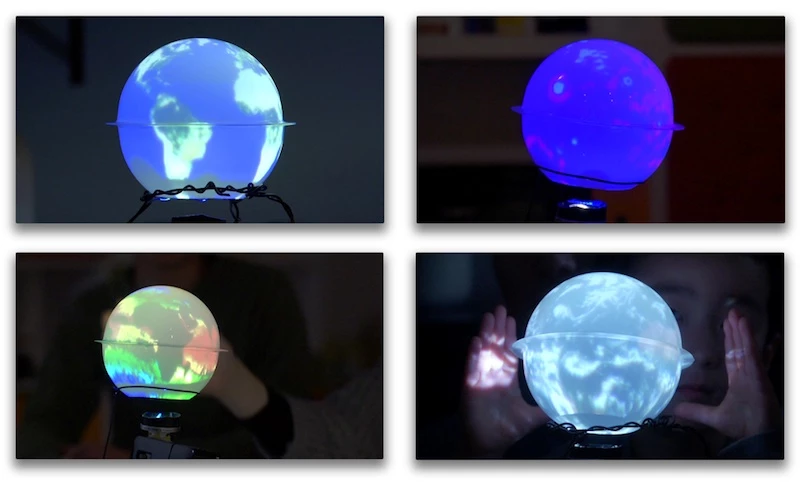
The “We Love Data” challenge asked teams to rethink how people relate to space data, and a clear standout was the Personal Cosmos display (shown below) which used simple supplies to project representations of Earth onto a paper sphere.

In the “Wish You Were Here” challenge, teams related the weather conditions on Mars to something people at home could identify with. Knowing that most people don't relate to numbers very well, the Mearth team developed a website that tells you which Earth city is most like Mars at that moment. Similarly, the Instamars team went even more conceptual and related Mars temperatures to popular conceptions of weather like “New York in winter.”

Amateur astronomers out there will appreciate the Starhopper redesign of the old Planet Hopper website. Allowing you to jump from star to star across the galaxy, each star, planet, and asteroid is clickable and searchable. Don't get lost.

“Catch a Meteor” was another popular challenge inviting teams to engage and educate the public about Near-Earth Objects, or shooting stars. The Falling Star Finder team imagined (but has not developed) a mobile app that opened up a cell phone's camera for long-exposure images and allowed the user to trace any resulting meteor trails. The app would use EXIF data for determining the vector streak coordinates for that particular find, and upload the information for data aggregation and social sharing.
Environmental Challenges
The “Renewable Energy Explorer” challenge asked teams to give the public resources to make better decisions about renewable energy. The Perpetuality team created a game using NASA solar energy maps. Players choose optimal locations for renewable energy plants and then make money off wise investments, with the intent to prove to the public the perpetuity of renewable energy. Their video located on the project page is amusing and worth a watch.

The NASA Greener Cities Project prototyped a sensor system for use in urban gardens that would collect microclimate data and feed it back to systems tracking macroscale pollution data. In addition to collecting data useful for gardening, it would also crowdsource greater understanding of the “street view” of climate, as they call it.
Space and Satellite Technology
Other challenges asked teams to look at known problems of space exploration and to extend the functionality of existing satellite systems. A popular challenge asked teams to design a greenhouse that could be deployed on the surface of Mars. One team incorporated an origami-inspired structure for compactness and crops varied from nutritionally-complete algae farms to aeroponic spinach gardens. A particular standout, the Space Veggies project, created a design which would conserve weight during space travel by using Mars sand to cover and protect the greenhouse. Its video is also worth a watch.
Several challenges focused on the satellite standard CubeSat, and its cousin, the ArduSat, which is an open-source, Arduino-based satellite designed to create easy access to space exploration for hobby astronomers. Teams were asked to design solutions which made use of the ArduSat's camera to automatically detect the horizon and the Sun, and to track stars. Alternatively, they could choose to use the ArduSat magnetometer and Geiger counter sensors to create experiments, record data, and add a competitive or social component to gamify data collection.

CubeWorld envisioned a CubeSat community designed for enthusiasts to share and find new CubeSat designs and propose new projects. The problem and the team's solution are creatively presented in their CubeWorld project video.
Remotely Operated Vehicles, LEGO and otherwise
One of the popular ROV challenges asked teams to design a LEGO robot system that would mimic a Mars rover for use in schools and clubs. The design constraints include time delays between sending commands and the ROV receiving commands, to simulate the Mars/Earth time delay. Teams were also challenged to enable children to design experiments or tests without knowing how to program the rover.
The Nepal-based Karkhana Rover team was inspired by William Gibson's observation that the future is already here, but unevenly distributed. Consequently, their kid-tested ROV solution didn't actually use LEGO, but a much cheaper Arduino-based model to reflect the economic needs of their communities.

The Curiosity@Play team, tasked with increasing interest in Mars Rover Curiosity, developed a cooperative web-based game that functions with a real Rover model. They consider this augmented reality to be not only more engaging, but true to the cooperation required in real space missions.

OpenROV, or the open-source remotely operated telerobotic submarine, is already a great technology for remotely exploring underwater locations. However, the Tiny Sea Bots team extended the functionality of OpenROV so that anyone can control a ROV online and also view its live underwater video stream – not unlike the AquatiCo Project. It's not difficult to imagine a whole online community collaborating on the remote exploration of a seabed.
The International Space Apps Challenge, called the largest hackathon ever but only requiring a few months to plan and a paltry US$70,000 to run, surely points at a different direction for space exploration, one rooted in collaboration and open source solutions. Global Best in Class prizes will be awarded on May 22 and the public can vote for their favorites with the link on each project page.
Source: International Space Apps Challenge via TheVerge


